Deposit Topo Map New York
To zoom in, hover over the map of Deposit
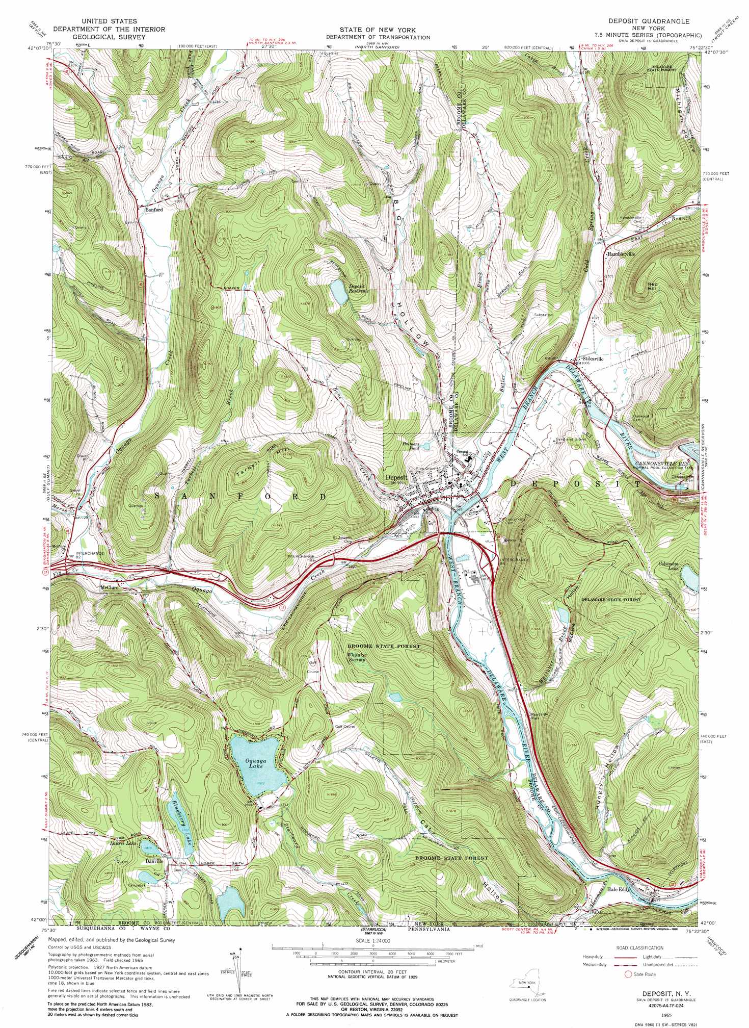
USGS Topo Quad 42075a4 - 1:24,000 scale
| Topo Map Name: | Deposit |
| USGS Topo Quad ID: | 42075a4 |
| Print Size: | ca. 21 1/4" wide x 27" high |
| Southeast Coordinates: | 42° N latitude / 75.375° W longitude |
| Map Center Coordinates: | 42.0625° N latitude / 75.4375° W longitude |
| U.S. State: | NY |
| Filename: | o42075a4.jpg |
| Download Map JPG Image: | Deposit topo map 1:24,000 scale |
| Map Type: | Topographic |
| Topo Series: | 7.5´ |
| Map Scale: | 1:24,000 |
| Source of Map Images: | United States Geological Survey (USGS) |
| Alternate Map Versions: |
Deposit NY 1965, updated 1967 Download PDF Buy paper map Deposit NY 1965, updated 1988 Download PDF Buy paper map Deposit NY 2010 Download PDF Buy paper map Deposit NY 2013 Download PDF Buy paper map Deposit NY 2016 Download PDF Buy paper map |
1:24,000 Topo Quads surrounding Deposit
Brisben |
West Bainbridge |
Sidney |
Unadilla |
Franklin |
Belden |
Afton |
North Sanford |
Trout Creek |
Walton West |
Windsor |
Gulf Summit |
Deposit |
Cannonsville Reservoir |
Readburn |
Great Bend |
Susquehanna |
Starrucca |
Hancock |
Fishs Eddy |
Harford |
Thompson |
Orson |
Lake Como |
Long Eddy |
> Back to 42075a1 at 1:100,000 scale
> Back to 42074a1 at 1:250,000 scale
> Back to U.S. Topo Maps home
Deposit topo map: Gazetteer
Deposit: Crossings
Interchange 82 elevation 339m 1112′Interchange 83 elevation 317m 1040′
Interchange 84 elevation 304m 997′
Deposit: Dams
Cannonsville Dam elevation 351m 1151′Deposit: Lakes
Blueberry Lake elevation 520m 1706′Columbia Lake elevation 460m 1509′
Laurel Lake elevation 552m 1811′
Oquaga Lake elevation 479m 1571′
Palmers Pond elevation 345m 1131′
Deposit: Mines
Amendola Bluestone Quarry elevation 551m 1807′Roods Creek Quarry elevation 351m 1151′
Deposit: Populated Places
Danville elevation 559m 1833′Deposit elevation 305m 1000′
Hale Eddy elevation 296m 971′
Hambletville elevation 325m 1066′
McClure elevation 327m 1072′
Sanford elevation 359m 1177′
Stilesville elevation 305m 1000′
Deposit: Reservoirs
Cannonsville Reservoir elevation 351m 1151′Deposit Reservoir elevation 486m 1594′
Deposit: Streams
Bone Creek elevation 302m 990′Butler Brook elevation 296m 971′
Cabin Brook elevation 359m 1177′
Cold Spring Creek elevation 301m 987′
East Branch Cold Spring Creek elevation 320m 1049′
Fly Creek elevation 328m 1076′
Marsh Creek elevation 335m 1099′
Oquaga Creek elevation 296m 971′
Page Pond Brook elevation 370m 1213′
Sherman Creek elevation 291m 954′
Tarbell Brook elevation 321m 1053′
Whitaker Brook elevation 296m 971′
Deposit: Summits
Red Hill elevation 536m 1758′Tarbell Hill elevation 580m 1902′
Deposit: Swamps
Whitaker Swamp elevation 419m 1374′Deposit: Valleys
Big Hollow elevation 312m 1023′Hungry Hollow elevation 310m 1017′
McCabe Hollow elevation 312m 1023′
Michigan Hollow elevation 346m 1135′
Deposit digital topo map on disk
Buy this Deposit topo map showing relief, roads, GPS coordinates and other geographical features, as a high-resolution digital map file on DVD:
New York, Vermont, Connecticut & Western Massachusetts
Buy digital topo maps: New York, Vermont, Connecticut & Western Massachusetts