Binghamton West Topo Map New York
To zoom in, hover over the map of Binghamton West
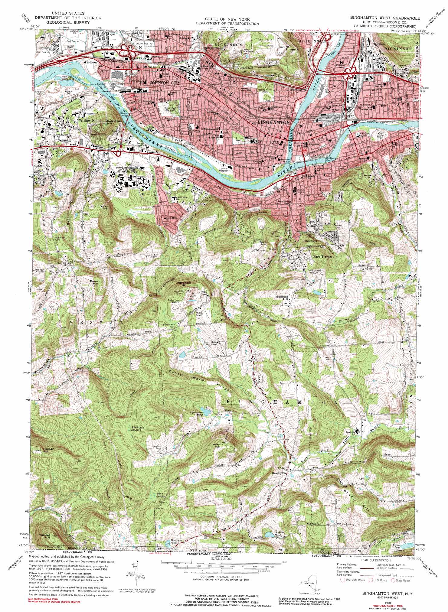
USGS Topo Quad 42075a8 - 1:24,000 scale
| Topo Map Name: | Binghamton West |
| USGS Topo Quad ID: | 42075a8 |
| Print Size: | ca. 21 1/4" wide x 27" high |
| Southeast Coordinates: | 42° N latitude / 75.875° W longitude |
| Map Center Coordinates: | 42.0625° N latitude / 75.9375° W longitude |
| U.S. State: | NY |
| Filename: | o42075a8.jpg |
| Download Map JPG Image: | Binghamton West topo map 1:24,000 scale |
| Map Type: | Topographic |
| Topo Series: | 7.5´ |
| Map Scale: | 1:24,000 |
| Source of Map Images: | United States Geological Survey (USGS) |
| Alternate Map Versions: |
Binghamton West NY 1935 Download PDF Buy paper map Binghamton West NY 1961, updated 1964 Download PDF Buy paper map Binghamton West NY 1968, updated 1972 Download PDF Buy paper map Binghamton West NY 1968, updated 1977 Download PDF Buy paper map Binghamton West NY 1968, updated 1988 Download PDF Buy paper map Binghamton West NY 2010 Download PDF Buy paper map Binghamton West NY 2013 Download PDF Buy paper map Binghamton West NY 2016 Download PDF Buy paper map |
1:24,000 Topo Quads surrounding Binghamton West
Richford |
Lisle |
Whitney Point |
Greene |
Brisben |
Newark Valley |
Maine |
Castle Creek |
Chenango Forks |
Belden |
Apalachin |
Endicott |
Binghamton West |
Binghamton East |
Windsor |
Little Meadows |
Friendsville |
Laurel Lake |
Franklin Forks |
Great Bend |
Le Raysville |
Lawton |
Montrose West |
Montrose East |
Harford |
> Back to 42075a1 at 1:100,000 scale
> Back to 42074a1 at 1:250,000 scale
> Back to U.S. Topo Maps home
Binghamton West topo map: Gazetteer
Binghamton West: Airports
Luke Airport elevation 473m 1551′Wilson Hospital Heliport elevation 260m 853′
Binghamton West: Bridges
CFJ Memorial Bridge elevation 248m 813′Binghamton West: Crossings
Interchange 4 elevation 261m 856′Interchange 70 elevation 257m 843′
Interchange 71 elevation 267m 875′
Interchange 72 elevation 270m 885′
Binghamton West: Dams
Rockbottom Dam elevation 250m 820′Binghamton West: Islands
Crocker Island elevation 252m 826′Binghamton West: Lakes
Clines Pond elevation 391m 1282′Jackson Pond elevation 487m 1597′
Monahan Pond elevation 510m 1673′
Binghamton West: Parks
Bintz Swimming Pool elevation 257m 843′Ely Park elevation 399m 1309′
Johnson Field elevation 258m 846′
Johnson-McArthur Field elevation 258m 846′
Phelps Park (historical) elevation 260m 853′
Ross Park elevation 386m 1266′
South Mountain Park elevation 414m 1358′
Southside Park elevation 254m 833′
Veterans Memorial Park elevation 264m 866′
Veterans Memorial Park elevation 256m 839′
Virginia Avenue Playground elevation 270m 885′
Binghamton West: Populated Places
Binghamton elevation 264m 866′Hawleyton elevation 388m 1272′
Johnson City elevation 266m 872′
Park Terrace elevation 387m 1269′
Stella (historical) elevation 271m 889′
Summit Hill elevation 493m 1617′
Sunrise Terrace elevation 267m 875′
Westover elevation 254m 833′
Willow Point elevation 270m 885′
Binghamton West: Reservoirs
Agwaterra Pond elevation 415m 1361′South Mountain Reservoir elevation 324m 1062′
Binghamton West: Ridges
Table Rock Ridge elevation 517m 1696′Binghamton West: Streams
Bayless Creek elevation 252m 826′Brandywine Creek elevation 258m 846′
Bunn Hill Creek elevation 250m 820′
Chamberlain Creek elevation 253m 830′
Chenango River elevation 250m 820′
Fuller Hollow Creek elevation 249m 816′
Glenwood Creek elevation 277m 908′
Little Choconut Creek elevation 247m 810′
Park Creek elevation 291m 954′
Binghamton West: Summits
Brady Hill elevation 545m 1788′Bunn Hill elevation 532m 1745′
Ingraham Hill elevation 556m 1824′
Lucky Hill elevation 550m 1804′
Mount Prospect elevation 434m 1423′
Pierson Hill elevation 501m 1643′
Roundtop Hill elevation 376m 1233′
Wildcat Hill elevation 480m 1574′
Binghamton West: Swamps
Bear Swamp elevation 498m 1633′Black Ash Swamp elevation 519m 1702′
Binghamton West: Valleys
Finch Hollow elevation 257m 843′Binghamton West digital topo map on disk
Buy this Binghamton West topo map showing relief, roads, GPS coordinates and other geographical features, as a high-resolution digital map file on DVD:
New York, Vermont, Connecticut & Western Massachusetts
Buy digital topo maps: New York, Vermont, Connecticut & Western Massachusetts