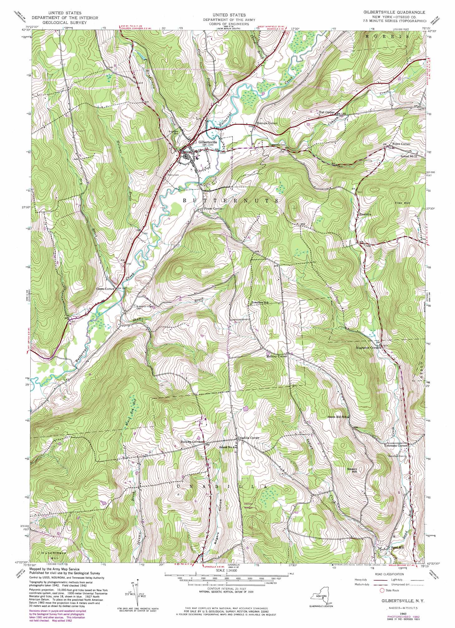
Gilbertsville Topo Map New York
To zoom in, hover over the map of Gilbertsville
USGS Topo Quad 42075d3 - 1:24,000 scale
| Topo Map Name: | Gilbertsville |
| USGS Topo Quad ID: | 42075d3 |
| Print Size: | ca. 21 1/4" wide x 27" high |
| Southeast Coordinates: | 42.375° N latitude / 75.25° W longitude |
| Map Center Coordinates: | 42.4375° N latitude / 75.3125° W longitude |
| U.S. State: | NY |
| Filename: | o42075d3.jpg |
| Download Map JPG Image: | Gilbertsville topo map 1:24,000 scale |
| Map Type: | Topographic |
| Topo Series: | 7.5´ |
| Map Scale: | 1:24,000 |
| Source of Map Images: | United States Geological Survey (USGS) |
| Alternate Map Versions: |
Gilbertsville NY 1943, updated 1960 Download PDF Buy paper map Gilbertsville NY 1943, updated 1983 Download PDF Buy paper map Gilbertsville NY 2010 Download PDF Buy paper map Gilbertsville NY 2013 Download PDF Buy paper map Gilbertsville NY 2016 Download PDF Buy paper map |
1:24,000 Topo Quads surrounding Gilbertsville
Earlville |
Sherburne |
New Berlin North |
Edmeston |
Hartwick |
Norwich |
Holmesville |
New Berlin South |
Morris |
Mount Vision |
Oxford |
Guilford |
Gilbertsville |
Otego |
Oneonta |
West Bainbridge |
Sidney |
Unadilla |
Franklin |
Treadwell |
Afton |
North Sanford |
Trout Creek |
Walton West |
Walton East |
> Back to 42075a1 at 1:100,000 scale
> Back to 42074a1 at 1:250,000 scale
> Back to U.S. Topo Maps home
Gilbertsville topo map: Gazetteer
Gilbertsville: Populated Places
Copes Corner elevation 321m 1053′Freer Corner elevation 456m 1496′
Frone Corner elevation 341m 1118′
Gilbertsville elevation 333m 1092′
Heslops Corner elevation 335m 1099′
Mallory Corner elevation 535m 1755′
Rootville elevation 482m 1581′
Sand Hill elevation 346m 1135′
Toll Corner elevation 390m 1279′
Unadilla Center elevation 536m 1758′
Youmans Corner elevation 381m 1250′
Gilbertsville: Streams
Butternut Creek elevation 305m 1000′Cahoon Creek elevation 317m 1040′
Coye Brook elevation 317m 1040′
Dry Brook elevation 312m 1023′
Dunderberg Creek elevation 317m 1040′
Halbert Brook elevation 314m 1030′
Indian Creek elevation 333m 1092′
Shaw Brook elevation 311m 1020′
Thorp Brook elevation 324m 1062′
Gilbertsville: Summits
Filer Hill elevation 592m 1942′Sisson Hill elevation 550m 1804′
Gilbertsville: Swamps
Black Ash Bog elevation 521m 1709′Gilbertsville digital topo map on disk
Buy this Gilbertsville topo map showing relief, roads, GPS coordinates and other geographical features, as a high-resolution digital map file on DVD:
New York, Vermont, Connecticut & Western Massachusetts
Buy digital topo maps: New York, Vermont, Connecticut & Western Massachusetts