Oxford Topo Map New York
To zoom in, hover over the map of Oxford
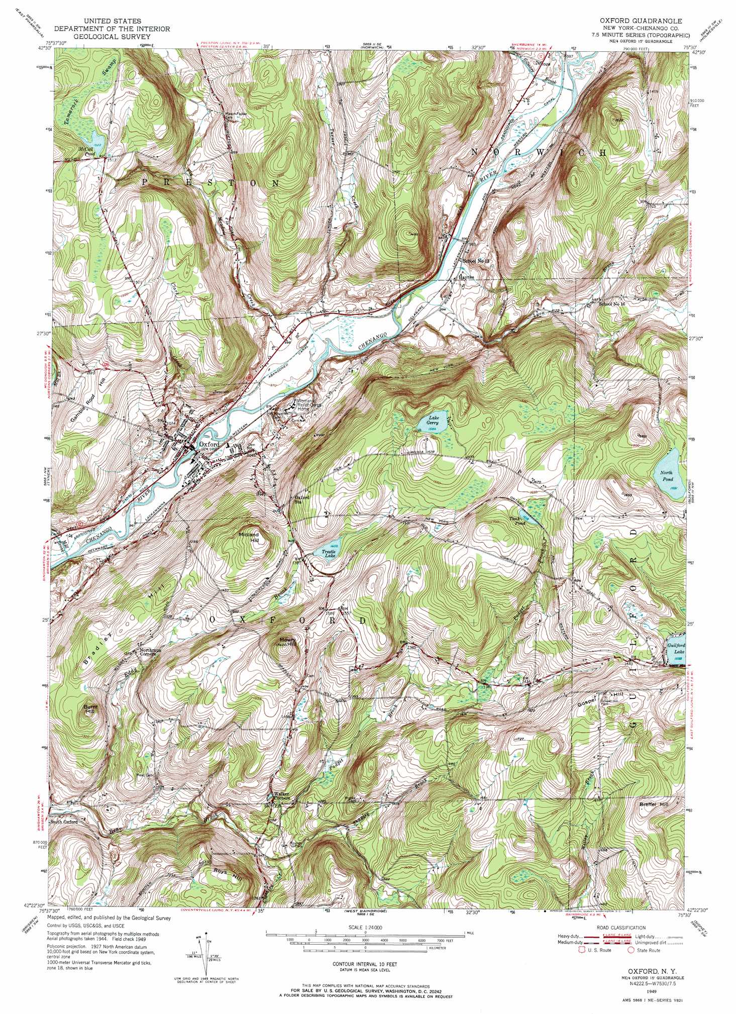
USGS Topo Quad 42075d5 - 1:24,000 scale
| Topo Map Name: | Oxford |
| USGS Topo Quad ID: | 42075d5 |
| Print Size: | ca. 21 1/4" wide x 27" high |
| Southeast Coordinates: | 42.375° N latitude / 75.5° W longitude |
| Map Center Coordinates: | 42.4375° N latitude / 75.5625° W longitude |
| U.S. State: | NY |
| Filename: | o42075d5.jpg |
| Download Map JPG Image: | Oxford topo map 1:24,000 scale |
| Map Type: | Topographic |
| Topo Series: | 7.5´ |
| Map Scale: | 1:24,000 |
| Source of Map Images: | United States Geological Survey (USGS) |
| Alternate Map Versions: |
Oxford NY 1949, updated 1967 Download PDF Buy paper map Oxford NY 1951 Download PDF Buy paper map Oxford NY 2010 Download PDF Buy paper map Oxford NY 2013 Download PDF Buy paper map Oxford NY 2016 Download PDF Buy paper map |
1:24,000 Topo Quads surrounding Oxford
South Otselic |
Otselic |
Earlville |
Sherburne |
New Berlin North |
Pitcher |
East Pharsalia |
Norwich |
Holmesville |
New Berlin South |
Smithville Flats |
Tyner |
Oxford |
Guilford |
Gilbertsville |
Greene |
Brisben |
West Bainbridge |
Sidney |
Unadilla |
Chenango Forks |
Belden |
Afton |
North Sanford |
Trout Creek |
> Back to 42075a1 at 1:100,000 scale
> Back to 42074a1 at 1:250,000 scale
> Back to U.S. Topo Maps home
Oxford topo map: Gazetteer
Oxford: Lakes
Lake Gerry elevation 483m 1584′McCall Pond elevation 465m 1525′
North Pond elevation 516m 1692′
Tank Pond elevation 493m 1617′
Oxford: Parks
Washington Park elevation 297m 974′Oxford: Populated Places
Haynes elevation 298m 977′Oxford elevation 296m 971′
South Oxford elevation 307m 1007′
Oxford: Reservoirs
Trestle Lake elevation 427m 1400′Oxford: Streams
Cheshire Creek elevation 341m 1118′Clark Creek elevation 293m 961′
Fly Meadow Creek elevation 295m 967′
Gilmore Brook elevation 296m 971′
Lyon Brook elevation 293m 961′
Mill Brook elevation 292m 958′
Padget Brook elevation 338m 1108′
Shapley Brook elevation 341m 1118′
Turner Creek elevation 301m 987′
Oxford: Summits
Bradley Hill elevation 421m 1381′Breffel Hill elevation 537m 1761′
Burnt Hill elevation 436m 1430′
Gamble Roof Hill elevation 406m 1332′
Gospel Hill elevation 528m 1732′
Midland Hill elevation 489m 1604′
Mowry Hill elevation 531m 1742′
Roys Hill elevation 468m 1535′
Oxford: Swamps
Tamarack Swamp elevation 465m 1525′Oxford digital topo map on disk
Buy this Oxford topo map showing relief, roads, GPS coordinates and other geographical features, as a high-resolution digital map file on DVD:
New York, Vermont, Connecticut & Western Massachusetts
Buy digital topo maps: New York, Vermont, Connecticut & Western Massachusetts