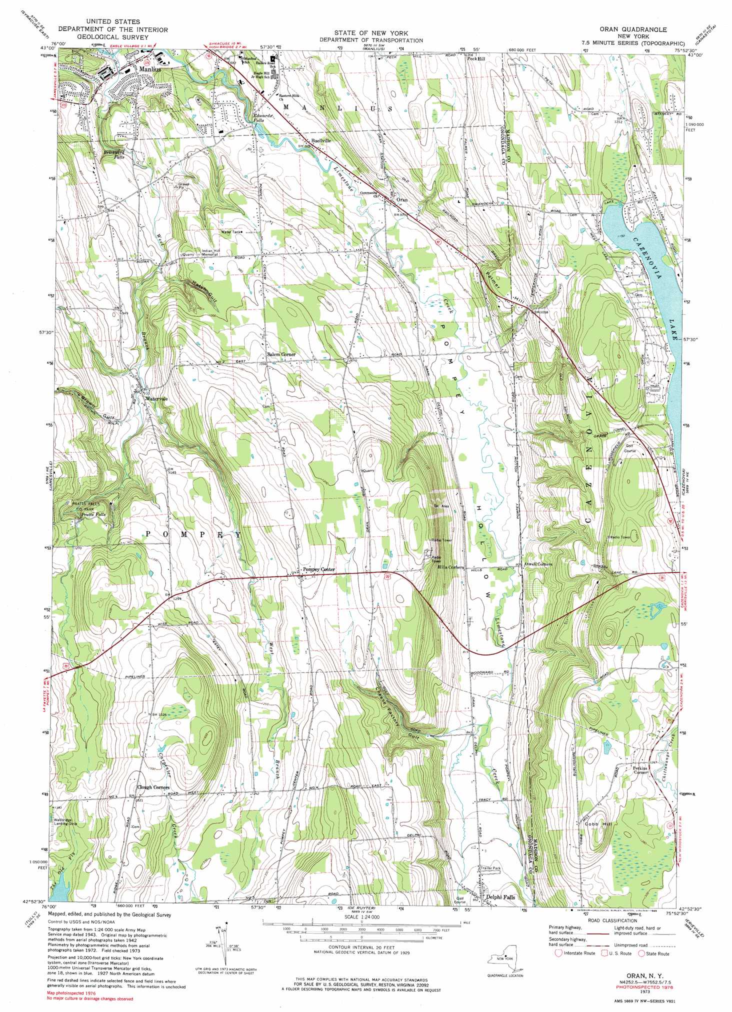
Oran Topo Map New York
To zoom in, hover over the map of Oran
USGS Topo Quad 42075h8 - 1:24,000 scale
| Topo Map Name: | Oran |
| USGS Topo Quad ID: | 42075h8 |
| Print Size: | ca. 21 1/4" wide x 27" high |
| Southeast Coordinates: | 42.875° N latitude / 75.875° W longitude |
| Map Center Coordinates: | 42.9375° N latitude / 75.9375° W longitude |
| U.S. State: | NY |
| Filename: | o42075h8.jpg |
| Download Map JPG Image: | Oran topo map 1:24,000 scale |
| Map Type: | Topographic |
| Topo Series: | 7.5´ |
| Map Scale: | 1:24,000 |
| Source of Map Images: | United States Geological Survey (USGS) |
| Alternate Map Versions: |
Oran NY 1942, updated 1957 Download PDF Buy paper map Oran NY 1943, updated 1960 Download PDF Buy paper map Oran NY 1973, updated 1975 Download PDF Buy paper map Oran NY 1973, updated 1985 Download PDF Buy paper map Oran NY 2010 Download PDF Buy paper map Oran NY 2013 Download PDF Buy paper map Oran NY 2016 Download PDF Buy paper map |
1:24,000 Topo Quads surrounding Oran
Brewerton |
Cicero |
Cleveland |
Jewell |
Sylvan Beach |
Syracuse West |
Syracuse East |
Manlius |
Canastota |
Oneida |
South Onondaga |
Jamesville |
Oran |
Cazenovia |
Morrisville |
Otisco Valley |
Tully |
De Ruyter |
Erieville |
West Eaton |
Homer |
Truxton |
Cuyler |
South Otselic |
Otselic |
> Back to 42075e1 at 1:100,000 scale
> Back to 42074a1 at 1:250,000 scale
> Back to U.S. Topo Maps home
Oran topo map: Gazetteer
Oran: Airports
Wallbridge Airport elevation 420m 1377′Oran: Falls
Brickyard Falls elevation 186m 610′Edwards Falls elevation 206m 675′
Pratts Falls elevation 373m 1223′
Oran: Mines
Delphi Pit elevation 271m 889′Oran: Parks
Indian Hill Memorial elevation 287m 941′Pratts Falls County Park elevation 354m 1161′
Oran: Populated Places
Atwell Corners elevation 245m 803′Buellville elevation 232m 761′
Delphi Falls elevation 289m 948′
Delphi Falls Park elevation 282m 925′
Oran elevation 245m 803′
Peck Hill elevation 366m 1200′
Perkins Corner elevation 386m 1266′
Pompey Center elevation 378m 1240′
Salem Corner elevation 332m 1089′
Watervale elevation 275m 902′
Oran: Streams
West Branch Limestone Creek elevation 159m 521′Oran: Summits
Cobb Hill elevation 447m 1466′Palmer Hill elevation 317m 1040′
Oran: Valleys
Brown Gulf elevation 269m 882′Cheese Factory Gulf elevation 256m 839′
Hatch Gulf elevation 243m 797′
Pompey Hollow elevation 220m 721′
Oran digital topo map on disk
Buy this Oran topo map showing relief, roads, GPS coordinates and other geographical features, as a high-resolution digital map file on DVD:
New York, Vermont, Connecticut & Western Massachusetts
Buy digital topo maps: New York, Vermont, Connecticut & Western Massachusetts