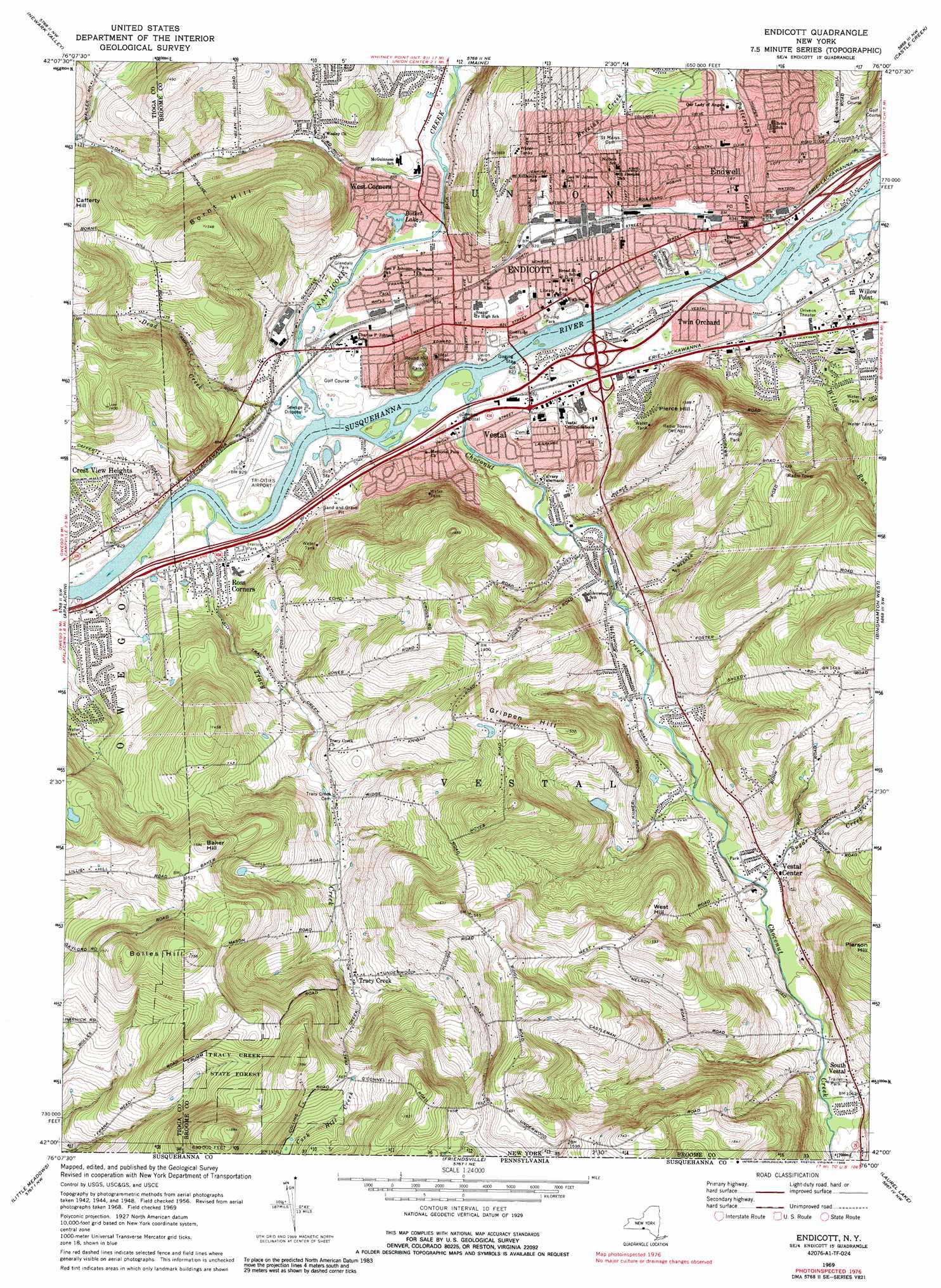
Endicott Topo Map New York
To zoom in, hover over the map of Endicott
USGS Topo Quad 42076a1 - 1:24,000 scale
| Topo Map Name: | Endicott |
| USGS Topo Quad ID: | 42076a1 |
| Print Size: | ca. 21 1/4" wide x 27" high |
| Southeast Coordinates: | 42° N latitude / 76° W longitude |
| Map Center Coordinates: | 42.0625° N latitude / 76.0625° W longitude |
| U.S. State: | NY |
| Filename: | o42076a1.jpg |
| Download Map JPG Image: | Endicott topo map 1:24,000 scale |
| Map Type: | Topographic |
| Topo Series: | 7.5´ |
| Map Scale: | 1:24,000 |
| Source of Map Images: | United States Geological Survey (USGS) |
| Alternate Map Versions: |
Endicott NY 1956, updated 1958 Download PDF Buy paper map Endicott NY 1956, updated 1967 Download PDF Buy paper map Endicott NY 1969, updated 1972 Download PDF Buy paper map Endicott NY 1969, updated 1978 Download PDF Buy paper map Endicott NY 1969, updated 1988 Download PDF Buy paper map Endicott NY 2010 Download PDF Buy paper map Endicott NY 2013 Download PDF Buy paper map Endicott NY 2016 Download PDF Buy paper map |
1:24,000 Topo Quads surrounding Endicott
Speedsville |
Richford |
Lisle |
Whitney Point |
Greene |
Candor |
Newark Valley |
Maine |
Castle Creek |
Chenango Forks |
Owego |
Apalachin |
Endicott |
Binghamton West |
Binghamton East |
Windham |
Little Meadows |
Friendsville |
Laurel Lake |
Franklin Forks |
Rome |
Le Raysville |
Lawton |
Montrose West |
Montrose East |
> Back to 42076a1 at 1:100,000 scale
> Back to 42076a1 at 1:250,000 scale
> Back to U.S. Topo Maps home
Endicott topo map: Gazetteer
Endicott: Airports
Tri-Cities Airport elevation 253m 830′Endicott: Bridges
Thomas J Watson Memorial Bridge elevation 245m 803′Endicott: Forests
Tracy Creek State Forest elevation 462m 1515′Endicott: Lakes
Bosket Lake elevation 252m 826′Endicott: Parks
Arnold Park elevation 406m 1332′En-Joie Park elevation 249m 816′
Glendale Park elevation 252m 826′
Round Hill Park elevation 328m 1076′
Union Park elevation 249m 816′
Endicott: Populated Places
Crest View Heights elevation 270m 885′Endicott elevation 256m 839′
Endwell elevation 258m 846′
Kintner Estates Mobile Home Park elevation 315m 1033′
Post Trailer Park elevation 283m 928′
Ross Corners elevation 257m 843′
South Vestal elevation 322m 1056′
Stephens Trailer Park elevation 261m 856′
Tioga Terrace elevation 288m 944′
Tracy Creek elevation 363m 1190′
Twin Orchard elevation 253m 830′
Vestal elevation 253m 830′
Vestal Center elevation 303m 994′
West Corners elevation 256m 839′
Endicott: Streams
Brixius Creek elevation 249m 816′Choconut Creek elevation 245m 803′
Choconut Creek elevation 245m 803′
Dead Creek elevation 245m 803′
Nanticoke Creek elevation 245m 803′
Patterson Creek elevation 246m 807′
Sugar Creek elevation 298m 977′
Tracy Creek elevation 245m 803′
Willow Run elevation 245m 803′
Endicott: Summits
Baker Hill elevation 483m 1584′Bolles Hill elevation 535m 1755′
Bornt Hill elevation 472m 1548′
Grippen Hill elevation 458m 1502′
Pierce Hill elevation 422m 1384′
West Hill elevation 445m 1459′
Endicott digital topo map on disk
Buy this Endicott topo map showing relief, roads, GPS coordinates and other geographical features, as a high-resolution digital map file on DVD:
New York, Vermont, Connecticut & Western Massachusetts
Buy digital topo maps: New York, Vermont, Connecticut & Western Massachusetts