Apalachin Topo Map New York
To zoom in, hover over the map of Apalachin
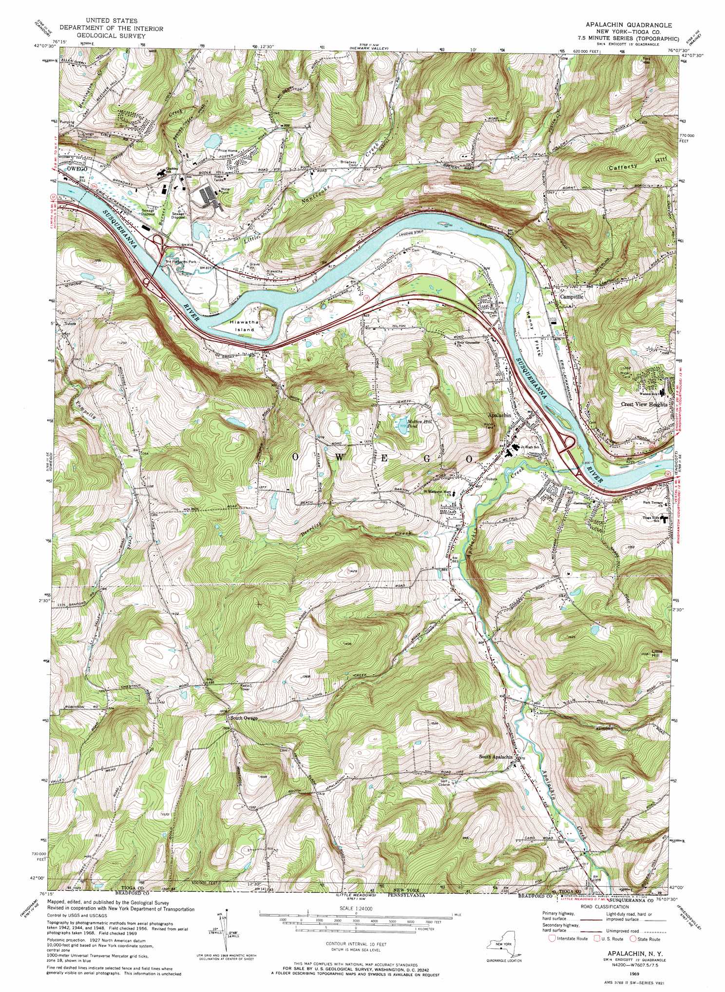
USGS Topo Quad 42076a2 - 1:24,000 scale
| Topo Map Name: | Apalachin |
| USGS Topo Quad ID: | 42076a2 |
| Print Size: | ca. 21 1/4" wide x 27" high |
| Southeast Coordinates: | 42° N latitude / 76.125° W longitude |
| Map Center Coordinates: | 42.0625° N latitude / 76.1875° W longitude |
| U.S. State: | NY |
| Filename: | o42076a2.jpg |
| Download Map JPG Image: | Apalachin topo map 1:24,000 scale |
| Map Type: | Topographic |
| Topo Series: | 7.5´ |
| Map Scale: | 1:24,000 |
| Source of Map Images: | United States Geological Survey (USGS) |
| Alternate Map Versions: |
Apalachin NY 1956, updated 1958 Download PDF Buy paper map Apalachin NY 1956, updated 1967 Download PDF Buy paper map Apalachin NY 1969, updated 1972 Download PDF Buy paper map Apalachin NY 1969, updated 1972 Download PDF Buy paper map Apalachin NY 2010 Download PDF Buy paper map Apalachin NY 2013 Download PDF Buy paper map Apalachin NY 2016 Download PDF Buy paper map |
1:24,000 Topo Quads surrounding Apalachin
Willseyville |
Speedsville |
Richford |
Lisle |
Whitney Point |
Spencer |
Candor |
Newark Valley |
Maine |
Castle Creek |
Barton |
Owego |
Apalachin |
Endicott |
Binghamton West |
Litchfield |
Windham |
Little Meadows |
Friendsville |
Laurel Lake |
Towanda |
Rome |
Le Raysville |
Lawton |
Montrose West |
> Back to 42076a1 at 1:100,000 scale
> Back to 42076a1 at 1:250,000 scale
> Back to U.S. Topo Maps home
Apalachin topo map: Gazetteer
Apalachin: Airports
IBM Owego Heliport elevation 278m 912′MDC Site 1 Heliport elevation 307m 1007′
Susquehanna Heliport elevation 250m 820′
Apalachin: Flats
Kenny Flats elevation 249m 816′Apalachin: Islands
Hiawatha Island elevation 249m 816′Apalachin: Lakes
Mutton Hill Pond elevation 359m 1177′Apalachin: Parks
Apalachin Marsh Bird Sanctuary elevation 249m 816′Boland Park elevation 255m 836′
Campville Commons elevation 265m 869′
Hiawatha Island Wildlife Refuge elevation 247m 810′
Muth Park elevation 262m 859′
The Hickories Park elevation 244m 800′
Apalachin: Populated Places
Apalachin elevation 257m 843′Campville elevation 256m 839′
Price Home elevation 317m 1040′
South Apalachin elevation 296m 971′
South Owego elevation 460m 1509′
Apalachin: Reservoirs
Owego Reservoir elevation 302m 990′Apalachin: Streams
Apalachin Creek elevation 243m 797′Apalachin Creek elevation 243m 797′
Barnes Creek elevation 243m 797′
Deerlick Creek elevation 260m 853′
Little Nanticoke Creek elevation 242m 793′
Apalachin: Summits
Cafferty Hill elevation 489m 1604′Lillie Hill elevation 488m 1601′
Apalachin digital topo map on disk
Buy this Apalachin topo map showing relief, roads, GPS coordinates and other geographical features, as a high-resolution digital map file on DVD:
New York, Vermont, Connecticut & Western Massachusetts
Buy digital topo maps: New York, Vermont, Connecticut & Western Massachusetts