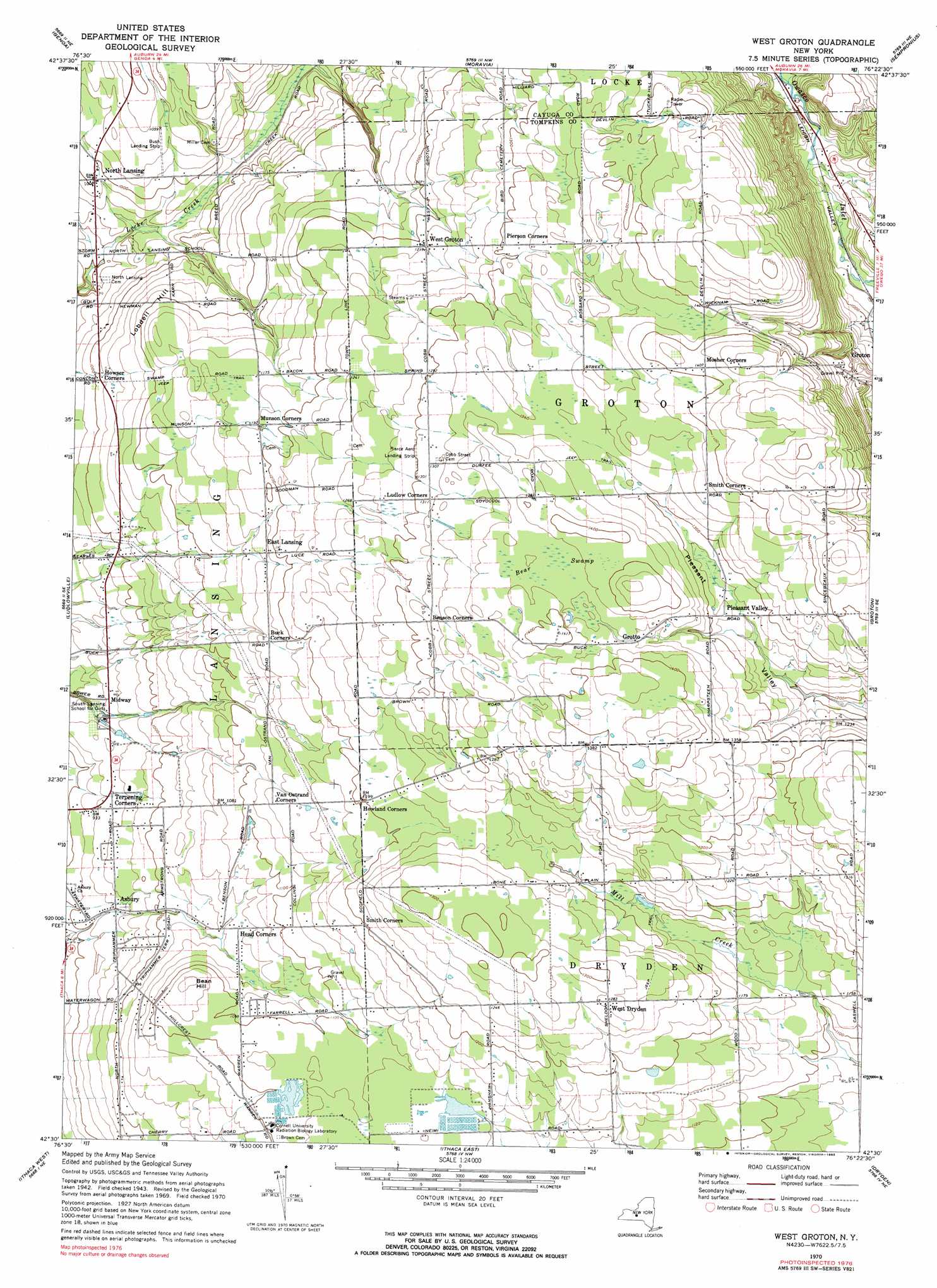
West Groton Topo Map New York
To zoom in, hover over the map of West Groton
USGS Topo Quad 42076e4 - 1:24,000 scale
| Topo Map Name: | West Groton |
| USGS Topo Quad ID: | 42076e4 |
| Print Size: | ca. 21 1/4" wide x 27" high |
| Southeast Coordinates: | 42.5° N latitude / 76.375° W longitude |
| Map Center Coordinates: | 42.5625° N latitude / 76.4375° W longitude |
| U.S. State: | NY |
| Filename: | o42076e4.jpg |
| Download Map JPG Image: | West Groton topo map 1:24,000 scale |
| Map Type: | Topographic |
| Topo Series: | 7.5´ |
| Map Scale: | 1:24,000 |
| Source of Map Images: | United States Geological Survey (USGS) |
| Alternate Map Versions: |
West Groton NY 1943, updated 1953 Download PDF Buy paper map West Groton NY 1943, updated 1966 Download PDF Buy paper map West Groton NY 1970, updated 1974 Download PDF Buy paper map West Groton NY 1970, updated 1983 Download PDF Buy paper map West Groton NY 2010 Download PDF Buy paper map West Groton NY 2013 Download PDF Buy paper map West Groton NY 2016 Download PDF Buy paper map |
1:24,000 Topo Quads surrounding West Groton
Union Springs |
Scipio Center |
Owasco |
Spafford |
Otisco Valley |
Sheldrake |
Genoa |
Moravia |
Sempronius |
Homer |
Trumansburg |
Ludlowville |
West Groton |
Groton |
Cortland |
Mecklenburg |
Ithaca West |
Ithaca East |
Dryden |
Harford |
Alpine |
West Danby |
Willseyville |
Speedsville |
Richford |
> Back to 42076e1 at 1:100,000 scale
> Back to 42076a1 at 1:250,000 scale
> Back to U.S. Topo Maps home
West Groton topo map: Gazetteer
West Groton: Airports
Bush Landing Strip elevation 319m 1046′Pierce Aero Landing Strip elevation 396m 1299′
West Groton: Populated Places
Asbury elevation 286m 938′Beacon View Village Mobile Home Park elevation 354m 1161′
East Lansing elevation 357m 1171′
Grotto elevation 408m 1338′
Head Corners elevation 320m 1049′
Howland Corners elevation 366m 1200′
Midway elevation 288m 944′
Mosher Corners elevation 430m 1410′
North Lansing elevation 305m 1000′
Pleasant Valley elevation 391m 1282′
Terpening Corners elevation 290m 951′
West Dryden elevation 391m 1282′
West Groton elevation 370m 1213′
West Groton: Summits
Bean Hill elevation 348m 1141′Lobdell Hill elevation 336m 1102′
West Groton: Swamps
Bear Swamp elevation 418m 1371′West Groton digital topo map on disk
Buy this West Groton topo map showing relief, roads, GPS coordinates and other geographical features, as a high-resolution digital map file on DVD:
New York, Vermont, Connecticut & Western Massachusetts
Buy digital topo maps: New York, Vermont, Connecticut & Western Massachusetts