Romulus Topo Map New York
To zoom in, hover over the map of Romulus
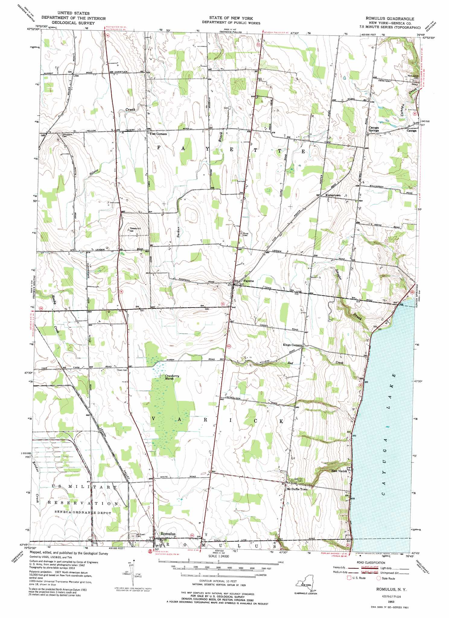
USGS Topo Quad 42076g7 - 1:24,000 scale
| Topo Map Name: | Romulus |
| USGS Topo Quad ID: | 42076g7 |
| Print Size: | ca. 21 1/4" wide x 27" high |
| Southeast Coordinates: | 42.75° N latitude / 76.75° W longitude |
| Map Center Coordinates: | 42.8125° N latitude / 76.8125° W longitude |
| U.S. State: | NY |
| Filename: | o42076g7.jpg |
| Download Map JPG Image: | Romulus topo map 1:24,000 scale |
| Map Type: | Topographic |
| Topo Series: | 7.5´ |
| Map Scale: | 1:24,000 |
| Source of Map Images: | United States Geological Survey (USGS) |
| Alternate Map Versions: |
Romulus NY 1953, updated 1955 Download PDF Buy paper map Romulus NY 1953, updated 1974 Download PDF Buy paper map Romulus NY 1953, updated 1989 Download PDF Buy paper map Romulus NY 2010 Download PDF Buy paper map Romulus NY 2013 Download PDF Buy paper map Romulus NY 2016 Download PDF Buy paper map |
1:24,000 Topo Quads surrounding Romulus
Newark |
Lyons |
Savannah |
Montezuma |
Weedsport |
Phelps |
Geneva North |
Seneca Falls |
Cayuga |
Auburn |
Stanley |
Geneva South |
Romulus |
Union Springs |
Scipio Center |
Penn Yan |
Dresden |
Ovid |
Sheldrake |
Genoa |
Keuka Park |
Dundee |
Lodi |
Trumansburg |
Ludlowville |
> Back to 42076e1 at 1:100,000 scale
> Back to 42076a1 at 1:250,000 scale
> Back to U.S. Topo Maps home
Romulus topo map: Gazetteer
Romulus: Airports
Airtrek Airport elevation 174m 570′Romulus: Populated Places
Canoga Springs elevation 138m 452′Clemsons Corners elevation 174m 570′
East Varick elevation 122m 400′
Fayette elevation 185m 606′
Kuneytown elevation 177m 580′
McDuffie Town elevation 183m 600′
Romulus elevation 219m 718′
Romulus: Streams
Burroughs Creek elevation 116m 380′Red Creek elevation 116m 380′
Schuyler Creek elevation 116m 380′
Romulus: Swamps
Cranberry Marsh elevation 203m 666′Romulus digital topo map on disk
Buy this Romulus topo map showing relief, roads, GPS coordinates and other geographical features, as a high-resolution digital map file on DVD:
New York, Vermont, Connecticut & Western Massachusetts
Buy digital topo maps: New York, Vermont, Connecticut & Western Massachusetts