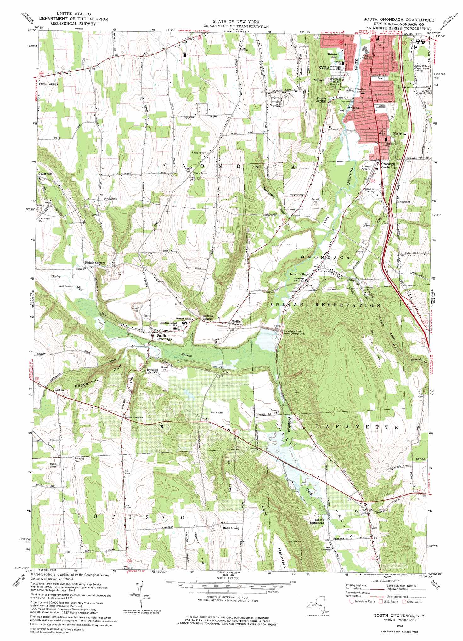
South Onondaga Topo Map New York
To zoom in, hover over the map of South Onondaga
USGS Topo Quad 42076h2 - 1:24,000 scale
| Topo Map Name: | South Onondaga |
| USGS Topo Quad ID: | 42076h2 |
| Print Size: | ca. 21 1/4" wide x 27" high |
| Southeast Coordinates: | 42.875° N latitude / 76.125° W longitude |
| Map Center Coordinates: | 42.9375° N latitude / 76.1875° W longitude |
| U.S. State: | NY |
| Filename: | o42076h2.jpg |
| Download Map JPG Image: | South Onondaga topo map 1:24,000 scale |
| Map Type: | Topographic |
| Topo Series: | 7.5´ |
| Map Scale: | 1:24,000 |
| Source of Map Images: | United States Geological Survey (USGS) |
| Alternate Map Versions: |
South Onondaga NY 1955, updated 1956 Download PDF Buy paper map South Onondaga NY 1955, updated 1962 Download PDF Buy paper map South Onondaga NY 1955, updated 1970 Download PDF Buy paper map South Onondaga NY 1973, updated 1977 Download PDF Buy paper map South Onondaga NY 2010 Download PDF Buy paper map South Onondaga NY 2013 Download PDF Buy paper map South Onondaga NY 2016 Download PDF Buy paper map |
1:24,000 Topo Quads surrounding South Onondaga
Lysander |
Baldwinsville |
Brewerton |
Cicero |
Cleveland |
Jordan |
Camillus |
Syracuse West |
Syracuse East |
Manlius |
Skaneateles |
Marcellus |
South Onondaga |
Jamesville |
Oran |
Owasco |
Spafford |
Otisco Valley |
Tully |
De Ruyter |
Moravia |
Sempronius |
Homer |
Truxton |
Cuyler |
> Back to 42076e1 at 1:100,000 scale
> Back to 42076a1 at 1:250,000 scale
> Back to U.S. Topo Maps home
South Onondaga topo map: Gazetteer
South Onondaga: Airports
Nedrow Airpark (historical) elevation 159m 521′South Onondaga: Dams
Onondaga Creek Flood Control Dam elevation 159m 521′South Onondaga: Lakes
Webster Pond elevation 131m 429′South Onondaga: Populated Places
Baileys Settlement elevation 154m 505′Cardiff elevation 186m 610′
Cedarvale elevation 185m 606′
Griffins Corners elevation 186m 610′
Indian Village elevation 145m 475′
Ironsides elevation 189m 620′
Joshua elevation 340m 1115′
Lords Corners elevation 338m 1108′
Maple Grove elevation 422m 1384′
Nedrow elevation 144m 472′
Nichols Corners elevation 180m 590′
Onondaga Castle elevation 156m 511′
Parc du Bois elevation 331m 1085′
South Onondaga elevation 180m 590′
South Onondaga: Springs
Dorwin Springs elevation 145m 475′South Onondaga: Streams
Commissary Creek elevation 128m 419′Hemlock Creek elevation 134m 439′
Kennedy Creek elevation 260m 853′
West Branch Onondaga Creek elevation 144m 472′
South Onondaga: Summits
Case Hill elevation 384m 1259′Lords Hill elevation 279m 915′
Manns Hill elevation 495m 1624′
South Onondaga: Valleys
Peppermill Gulf elevation 159m 521′Smoky Hollow elevation 238m 780′
Tully Valley elevation 143m 469′
Webb Hollow elevation 147m 482′
South Onondaga digital topo map on disk
Buy this South Onondaga topo map showing relief, roads, GPS coordinates and other geographical features, as a high-resolution digital map file on DVD:
New York, Vermont, Connecticut & Western Massachusetts
Buy digital topo maps: New York, Vermont, Connecticut & Western Massachusetts