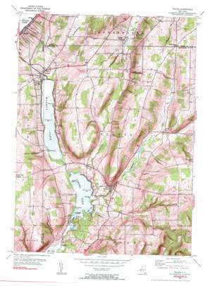
Wayne Topo Map New York
To zoom in, hover over the map of Wayne
USGS Topo Quad 42077d1 - 1:24,000 scale
| Topo Map Name: | Wayne |
| USGS Topo Quad ID: | 42077d1 |
| Print Size: | ca. 21 1/4" wide x 27" high |
| Southeast Coordinates: | 42.375° N latitude / 77° W longitude |
| Map Center Coordinates: | 42.4375° N latitude / 77.0625° W longitude |
| U.S. State: | NY |
| Filename: | o42077d1.jpg |
| Download Map JPG Image: | Wayne topo map 1:24,000 scale |
| Map Type: | Topographic |
| Topo Series: | 7.5´ |
| Map Scale: | 1:24,000 |
| Source of Map Images: | United States Geological Survey (USGS) |
| Alternate Map Versions: |
Wayne NY 1953, updated 1954 Download PDF Buy paper map Wayne NY 1953, updated 1954 Download PDF Buy paper map Wayne NY 2010 Download PDF Buy paper map Wayne NY 2013 Download PDF Buy paper map Wayne NY 2016 Download PDF Buy paper map |
1:24,000 Topo Quads surrounding Wayne
> Back to 42077a1 at 1:100,000 scale
> Back to 42076a1 at 1:250,000 scale
> Back to U.S. Topo Maps home
Wayne topo map: Gazetteer
Wayne: Bays
Fleet Cove elevation 335m 1099′Wayne: Capes
Barnards Point elevation 335m 1099′Kendell Point elevation 219m 718′
Pitchers Point elevation 335m 1099′
Swarthout Point elevation 337m 1105′
Wayne: Islands
Poplar Island elevation 338m 1108′Red Bank elevation 335m 1099′
Stingers Island elevation 337m 1105′
Wayne: Lakes
Lamoka Lake elevation 335m 1099′Wayne: Populated Places
Altay elevation 375m 1230′Crystal Spring elevation 340m 1115′
Keuka elevation 221m 725′
Shorewood elevation 336m 1102′
Sylvan Beach elevation 342m 1122′
Tyrone elevation 357m 1171′
Wayne elevation 356m 1167′
Weston elevation 366m 1200′
Wayne: Reservoirs
Waneta Lake elevation 335m 1099′Wayne: Ridges
Sebring Hill elevation 511m 1676′Wayne: Streams
Little Tobehanna Creek elevation 335m 1099′Tobehanna Creek elevation 335m 1099′
Wayne: Summits
Barrington Hill elevation 459m 1505′House Hill elevation 521m 1709′
Huey Hill elevation 576m 1889′
Six Nations Hill elevation 543m 1781′
Stocking Hill elevation 482m 1581′
Whitehead Hill elevation 488m 1601′
Wayne digital topo map on disk
Buy this Wayne topo map showing relief, roads, GPS coordinates and other geographical features, as a high-resolution digital map file on DVD:
New York, Vermont, Connecticut & Western Massachusetts
Buy digital topo maps: New York, Vermont, Connecticut & Western Massachusetts


