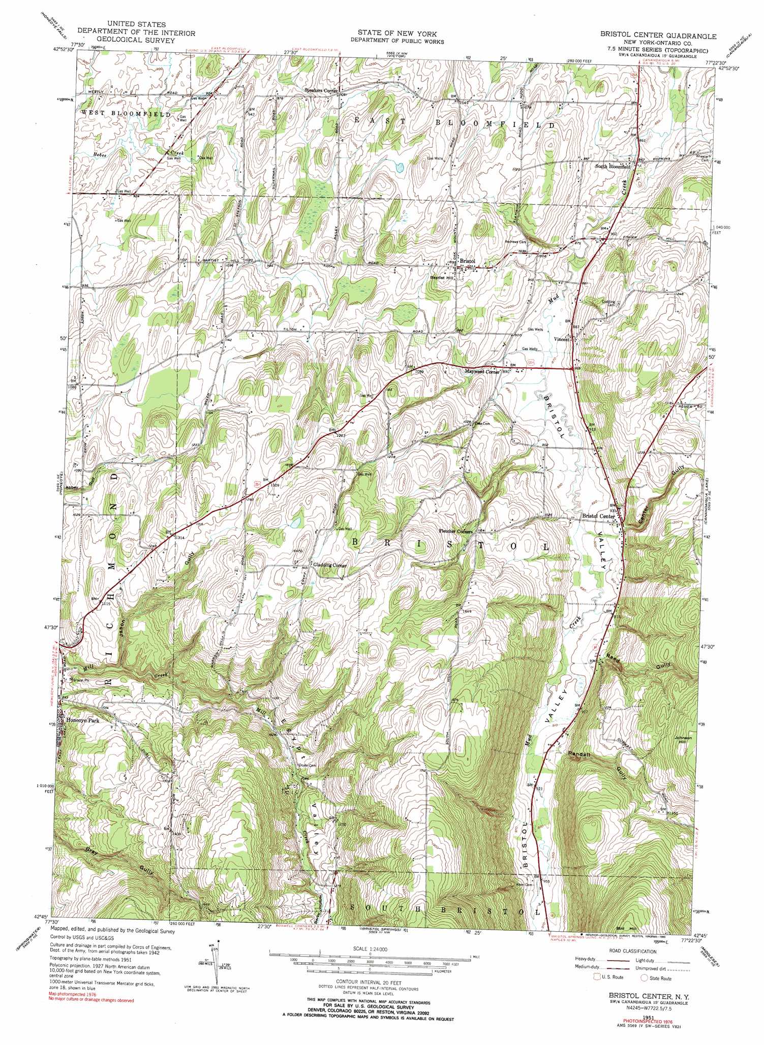
Bristol Center Topo Map New York
To zoom in, hover over the map of Bristol Center
USGS Topo Quad 42077g4 - 1:24,000 scale
| Topo Map Name: | Bristol Center |
| USGS Topo Quad ID: | 42077g4 |
| Print Size: | ca. 21 1/4" wide x 27" high |
| Southeast Coordinates: | 42.75° N latitude / 77.375° W longitude |
| Map Center Coordinates: | 42.8125° N latitude / 77.4375° W longitude |
| U.S. State: | NY |
| Filename: | o42077g4.jpg |
| Download Map JPG Image: | Bristol Center topo map 1:24,000 scale |
| Map Type: | Topographic |
| Topo Series: | 7.5´ |
| Map Scale: | 1:24,000 |
| Source of Map Images: | United States Geological Survey (USGS) |
| Alternate Map Versions: |
Bristol Center NY 1951, updated 1952 Download PDF Buy paper map Bristol Center NY 1951, updated 1960 Download PDF Buy paper map Bristol Center NY 1951, updated 1967 Download PDF Buy paper map Bristol Center NY 1951, updated 1990 Download PDF Buy paper map Bristol Center NY 2010 Download PDF Buy paper map Bristol Center NY 2013 Download PDF Buy paper map Bristol Center NY 2016 Download PDF Buy paper map |
1:24,000 Topo Quads surrounding Bristol Center
West Henrietta |
Pittsford |
Fairport |
Macedon |
Palmyra |
Rush |
Honeoye Falls |
Victor |
Canandaigua |
Clifton Springs |
Livonia |
Honeoye |
Bristol Center |
Canandaigua Lake |
Rushville |
Conesus |
Springwater |
Bristol Springs |
Middlesex |
Potter |
Dansville |
Wayland |
Naples |
Prattsburg |
Pulteney |
> Back to 42077e1 at 1:100,000 scale
> Back to 42076a1 at 1:250,000 scale
> Back to U.S. Topo Maps home
Bristol Center topo map: Gazetteer
Bristol Center: Populated Places
Bristol elevation 355m 1164′Bristol Center elevation 285m 935′
Gladding Corner elevation 441m 1446′
Mayweed Corner elevation 272m 892′
South Bloomfield elevation 265m 869′
Speakers Corner elevation 325m 1066′
Vincent elevation 277m 908′
Bristol Center: Summits
Baptist Hill elevation 356m 1167′Bristol Center: Valleys
Berby Hollow elevation 367m 1204′Bristol Valley elevation 264m 866′
Center Gully elevation 287m 941′
Egypt Valley elevation 260m 853′
Jason Gully elevation 266m 872′
Randall Gully elevation 286m 938′
Reed Gully elevation 274m 898′
Bristol Center digital topo map on disk
Buy this Bristol Center topo map showing relief, roads, GPS coordinates and other geographical features, as a high-resolution digital map file on DVD:
New York, Vermont, Connecticut & Western Massachusetts
Buy digital topo maps: New York, Vermont, Connecticut & Western Massachusetts