Livonia Topo Map New York
To zoom in, hover over the map of Livonia
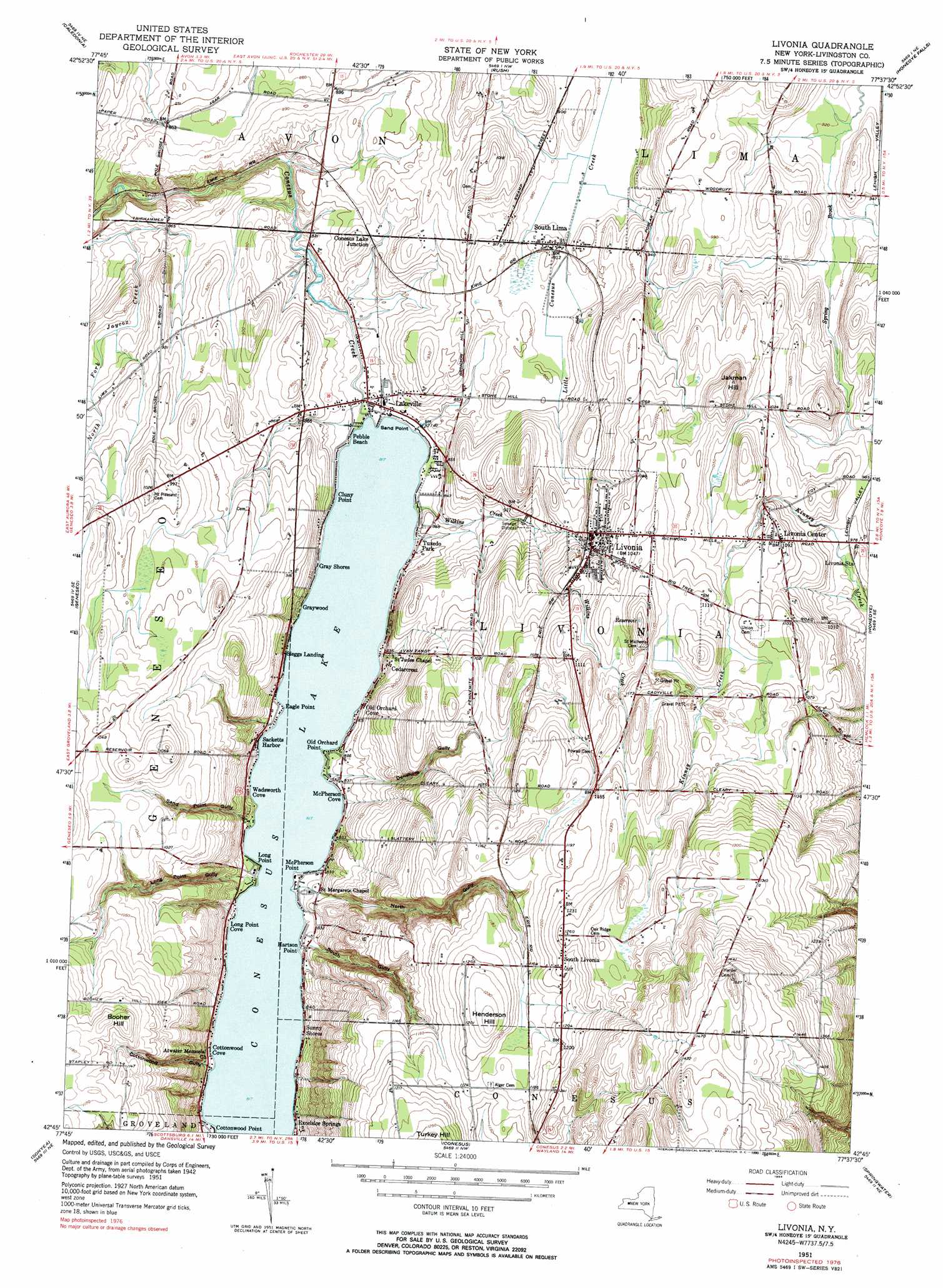
USGS Topo Quad 42077g6 - 1:24,000 scale
| Topo Map Name: | Livonia |
| USGS Topo Quad ID: | 42077g6 |
| Print Size: | ca. 21 1/4" wide x 27" high |
| Southeast Coordinates: | 42.75° N latitude / 77.625° W longitude |
| Map Center Coordinates: | 42.8125° N latitude / 77.6875° W longitude |
| U.S. State: | NY |
| Filename: | o42077g6.jpg |
| Download Map JPG Image: | Livonia topo map 1:24,000 scale |
| Map Type: | Topographic |
| Topo Series: | 7.5´ |
| Map Scale: | 1:24,000 |
| Source of Map Images: | United States Geological Survey (USGS) |
| Alternate Map Versions: |
Livonia NY 1951, updated 1952 Download PDF Buy paper map Livonia NY 1951, updated 1964 Download PDF Buy paper map Livonia NY 1951, updated 1984 Download PDF Buy paper map Livonia NY 1951, updated 1990 Download PDF Buy paper map Livonia NY 2010 Download PDF Buy paper map Livonia NY 2013 Download PDF Buy paper map Livonia NY 2016 Download PDF Buy paper map |
1:24,000 Topo Quads surrounding Livonia
Churchville |
Clifton |
West Henrietta |
Pittsford |
Fairport |
Le Roy |
Caledonia |
Rush |
Honeoye Falls |
Victor |
Leicester |
Geneseo |
Livonia |
Honeoye |
Bristol Center |
Mount Morris |
Sonyea |
Conesus |
Springwater |
Bristol Springs |
Nunda |
Ossian |
Dansville |
Wayland |
Naples |
> Back to 42077e1 at 1:100,000 scale
> Back to 42076a1 at 1:250,000 scale
> Back to U.S. Topo Maps home
Livonia topo map: Gazetteer
Livonia: Airports
Hannas Acres Airport elevation 279m 915′Livonia: Lakes
Conesus Lake elevation 249m 816′Livonia: Populated Places
Cedarcrest elevation 262m 859′Cluny Point elevation 249m 816′
Conesus Lake Junction elevation 265m 869′
Cottonwood Cove elevation 249m 816′
Cottonwood Point elevation 251m 823′
Eagle Point elevation 250m 820′
Excelsior Springs elevation 255m 836′
Gray Shores elevation 250m 820′
Graywood elevation 253m 830′
Hartson Point elevation 251m 823′
Lakeville elevation 251m 823′
Livonia elevation 315m 1033′
Livonia Center elevation 331m 1085′
Long Point Cove elevation 249m 816′
McPherson Cove elevation 251m 823′
McPherson Point elevation 251m 823′
Old Orchard Cove elevation 256m 839′
Old Orchard Point elevation 250m 820′
Pebble Beach elevation 250m 820′
Sacketts Harbor elevation 257m 843′
Sand Point elevation 250m 820′
Sleggs Landing elevation 253m 830′
South Lima elevation 271m 889′
South Livonia elevation 373m 1223′
Sunny Shores elevation 254m 833′
Tuxedo Park elevation 251m 823′
Wadsworth Cove elevation 255m 836′
Livonia: Streams
North Fork Jaycox Creek elevation 246m 807′Wilkins Creek elevation 249m 816′
Livonia: Summits
Booher Hill elevation 360m 1181′Henderson Hill elevation 379m 1243′
Jakman Hill elevation 357m 1171′
Livonia: Valleys
Cottonwood Gully elevation 255m 836′Denshore Gully elevation 270m 885′
Long Point Gully elevation 254m 833′
North Gully elevation 261m 856′
Sand Point Gully elevation 259m 849′
South Gully elevation 257m 843′
Livonia digital topo map on disk
Buy this Livonia topo map showing relief, roads, GPS coordinates and other geographical features, as a high-resolution digital map file on DVD:
New York, Vermont, Connecticut & Western Massachusetts
Buy digital topo maps: New York, Vermont, Connecticut & Western Massachusetts