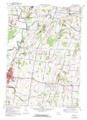
Rush Topo Map New York
To zoom in, hover over the map of Rush
USGS Topo Quad 42077h6 - 1:24,000 scale
| Topo Map Name: | Rush |
| USGS Topo Quad ID: | 42077h6 |
| Print Size: | ca. 21 1/4" wide x 27" high |
| Southeast Coordinates: | 42.875° N latitude / 77.625° W longitude |
| Map Center Coordinates: | 42.9375° N latitude / 77.6875° W longitude |
| U.S. State: | NY |
| Filename: | o42077h6.jpg |
| Download Map JPG Image: | Rush topo map 1:24,000 scale |
| Map Type: | Topographic |
| Topo Series: | 7.5´ |
| Map Scale: | 1:24,000 |
| Source of Map Images: | United States Geological Survey (USGS) |
| Alternate Map Versions: |
Rush NY 1931 Download PDF Buy paper map Rush NY 1934 Download PDF Buy paper map Rush NY 1934, updated 1950 Download PDF Buy paper map Rush NY 1951, updated 1952 Download PDF Buy paper map Rush NY 1951, updated 1966 Download PDF Buy paper map Rush NY 1971, updated 1973 Download PDF Buy paper map Rush NY 1971, updated 1973 Download PDF Buy paper map Rush NY 1971, updated 1991 Download PDF Buy paper map Rush NY 2010 Download PDF Buy paper map Rush NY 2013 Download PDF Buy paper map Rush NY 2016 Download PDF Buy paper map |
1:24,000 Topo Quads surrounding Rush
> Back to 42077e1 at 1:100,000 scale
> Back to 42076a1 at 1:250,000 scale
> Back to U.S. Topo Maps home
Rush topo map: Gazetteer
Rush: Airports
Bedsons Land Base Airport elevation 241m 790′Rush: Lakes
Horseshoe Pond elevation 159m 521′Log Pond elevation 160m 524′
Rush: Parks
Memorial Park elevation 198m 649′Rush: Populated Places
Avon elevation 198m 649′East Avon elevation 250m 820′
Five Points elevation 188m 616′
Golah elevation 165m 541′
Meadow Wood elevation 177m 580′
North Avon elevation 219m 718′
Rush elevation 168m 551′
West Rush elevation 171m 561′
Rush: Reservoirs
Avon Reservoir (historical) elevation 243m 797′Rush: Streams
Dugan Creek elevation 158m 518′Honeoye Creek elevation 156m 511′
Rush digital topo map on disk
Buy this Rush topo map showing relief, roads, GPS coordinates and other geographical features, as a high-resolution digital map file on DVD:
New York, Vermont, Connecticut & Western Massachusetts
Buy digital topo maps: New York, Vermont, Connecticut & Western Massachusetts


