Portville Topo Map New York
To zoom in, hover over the map of Portville
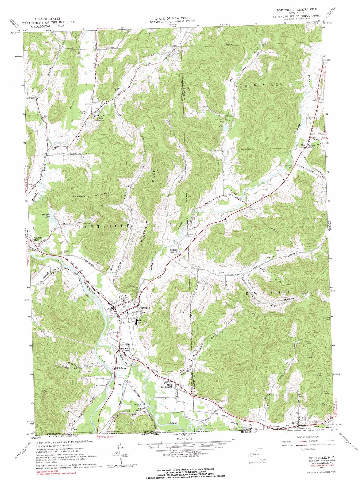
USGS Topo Quad 42078a3 - 1:24,000 scale
| Topo Map Name: | Portville |
| USGS Topo Quad ID: | 42078a3 |
| Print Size: | ca. 21 1/4" wide x 27" high |
| Southeast Coordinates: | 42° N latitude / 78.25° W longitude |
| Map Center Coordinates: | 42.0625° N latitude / 78.3125° W longitude |
| U.S. State: | NY |
| Filename: | o42078a3.jpg |
| Download Map JPG Image: | Portville topo map 1:24,000 scale |
| Map Type: | Topographic |
| Topo Series: | 7.5´ |
| Map Scale: | 1:24,000 |
| Source of Map Images: | United States Geological Survey (USGS) |
| Alternate Map Versions: |
Portville NY 1961, updated 1963 Download PDF Buy paper map Portville NY 1961, updated 1970 Download PDF Buy paper map Portville NY 1961, updated 1990 Download PDF Buy paper map Portville NY 2010 Download PDF Buy paper map Portville NY 2013 Download PDF Buy paper map Portville NY 2016 Download PDF Buy paper map |
1:24,000 Topo Quads surrounding Portville
Ashford |
Franklinville |
Rawson |
Black Creek |
Angelica |
Humphrey |
Hinsdale |
Cuba |
Friendship |
Belmont |
Knapp Creek |
Olean |
Portville |
Bolivar |
Allentown |
Derrick City |
Eldred |
Bullis Mills |
Shinglehouse |
Oswayo |
Cyclone |
Smethport |
Port Allegany |
Roulette |
Coudersport |
> Back to 42078a1 at 1:100,000 scale
> Back to 42078a1 at 1:250,000 scale
> Back to U.S. Topo Maps home
Portville topo map: Gazetteer
Portville: Airports
Ceres Airport elevation 533m 1748′Reiss Game Farm Airport elevation 513m 1683′
Portville: Lakes
Stephens Lake elevation 443m 1453′Portville: Populated Places
Bedford Corners elevation 452m 1482′Carroll elevation 437m 1433′
Lake View Terrace elevation 448m 1469′
Main Settlement elevation 440m 1443′
Mill Grove elevation 436m 1430′
Obi elevation 464m 1522′
Portville elevation 436m 1430′
Toll Gate Corner elevation 436m 1430′
Weston Mills elevation 446m 1463′
Portville: Ridges
Portville Ridge elevation 676m 2217′Portville: Streams
Bells Brook elevation 437m 1433′Butternut Brook elevation 427m 1400′
Coon Branch elevation 441m 1446′
Deer Creek elevation 443m 1453′
Dodge Creek elevation 429m 1407′
Lillibridge Creek elevation 427m 1400′
Oswayo Creek elevation 427m 1400′
Wayman Branch elevation 433m 1420′
Wolf Creek elevation 450m 1476′
Wolf Run elevation 442m 1450′
Portville: Summits
Typnahda Mountain elevation 624m 2047′Portville: Valleys
Bear Valley elevation 493m 1617′Coon Hollow elevation 460m 1509′
Doget Hollow elevation 463m 1519′
Gleason Hollow elevation 435m 1427′
Narvoo Hollow elevation 483m 1584′
Portville digital topo map on disk
Buy this Portville topo map showing relief, roads, GPS coordinates and other geographical features, as a high-resolution digital map file on DVD:
 map DVD")