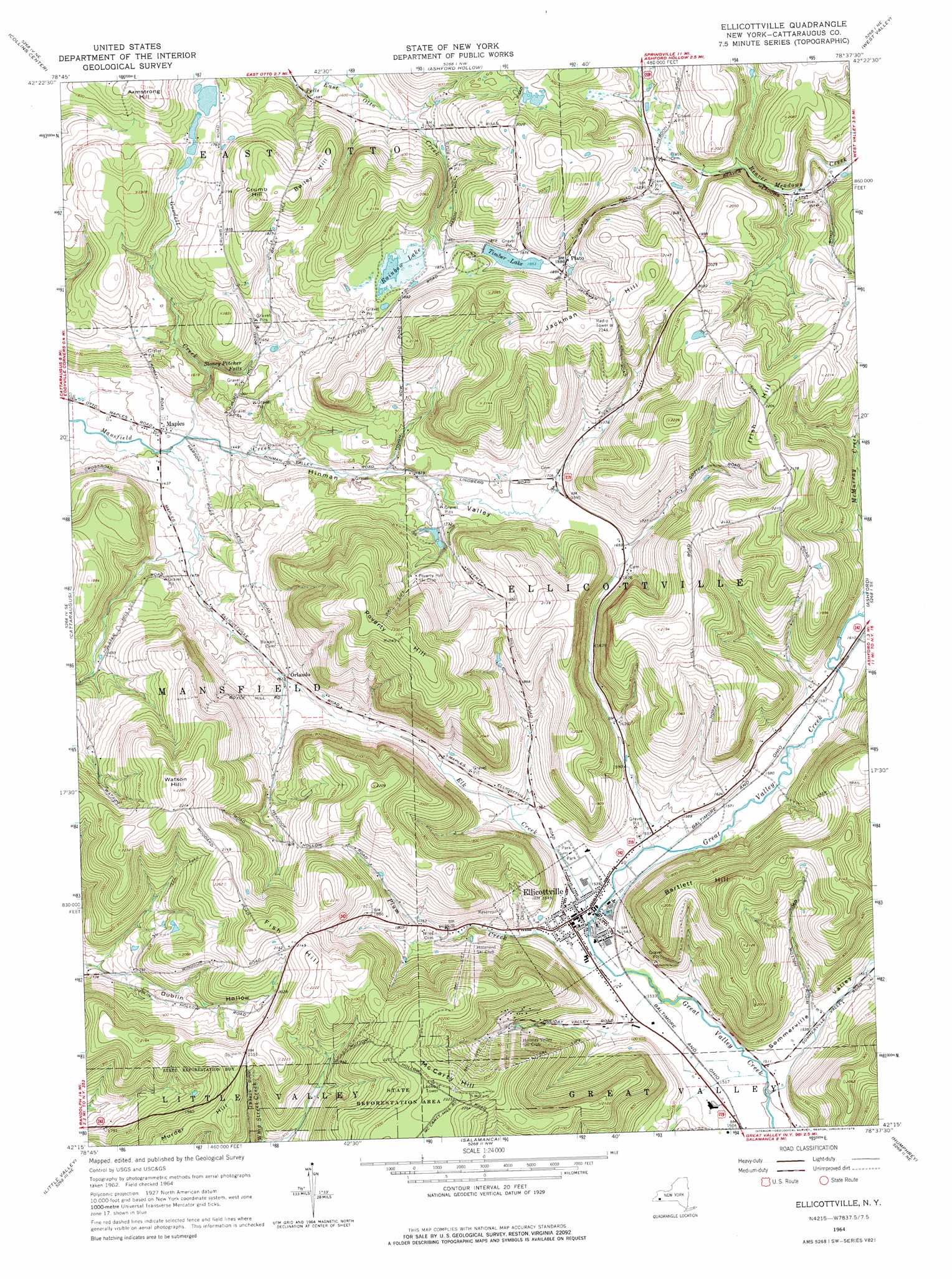
Ellicottville Topo Map New York
To zoom in, hover over the map of Ellicottville
USGS Topo Quad 42078c6 - 1:24,000 scale
| Topo Map Name: | Ellicottville |
| USGS Topo Quad ID: | 42078c6 |
| Print Size: | ca. 21 1/4" wide x 27" high |
| Southeast Coordinates: | 42.25° N latitude / 78.625° W longitude |
| Map Center Coordinates: | 42.3125° N latitude / 78.6875° W longitude |
| U.S. State: | NY |
| Filename: | o42078c6.jpg |
| Download Map JPG Image: | Ellicottville topo map 1:24,000 scale |
| Map Type: | Topographic |
| Topo Series: | 7.5´ |
| Map Scale: | 1:24,000 |
| Source of Map Images: | United States Geological Survey (USGS) |
| Alternate Map Versions: |
Ellicottville NY 1964, updated 1965 Download PDF Buy paper map Ellicottville NY 1964, updated 1976 Download PDF Buy paper map Ellicottville NY 2010 Download PDF Buy paper map Ellicottville NY 2013 Download PDF Buy paper map Ellicottville NY 2016 Download PDF Buy paper map |
1:24,000 Topo Quads surrounding Ellicottville
North Collins |
Langford |
Springville |
Sardinia |
Arcade |
Gowanda |
Collins Center |
Ashford Hollow |
West Valley |
Delevan |
New Albion |
Cattaraugus |
Ellicottville |
Ashford |
Franklinville |
Randolph |
Little Valley |
Salamanca |
Humphrey |
Hinsdale |
Steamburg |
Red House |
Limestone |
Knapp Creek |
Olean |
> Back to 42078a1 at 1:100,000 scale
> Back to 42078a1 at 1:250,000 scale
> Back to U.S. Topo Maps home
Ellicottville topo map: Gazetteer
Ellicottville: Falls
Stoney Pitcher Falls elevation 479m 1571′Ellicottville: Populated Places
Ellicottville elevation 472m 1548′Maples elevation 431m 1414′
Orlando elevation 492m 1614′
Plato elevation 575m 1886′
Ellicottville: Reservoirs
Rainbow Lake elevation 559m 1833′Timber Lake elevation 567m 1860′
Ellicottville: Streams
Elk Creek elevation 461m 1512′Goodell Creek elevation 425m 1394′
McMurray Creek elevation 488m 1601′
Plum Creek elevation 462m 1515′
Ellicottville: Summits
Armstrong Hill elevation 591m 1938′Bailey Hill elevation 612m 2007′
Bartlett Hill elevation 624m 2047′
Crumb Hill elevation 622m 2040′
Fish Hill elevation 697m 2286′
Irish Hill elevation 683m 2240′
Jackman Hill elevation 664m 2178′
McCarty Hill elevation 710m 2329′
Murder Hill elevation 667m 2188′
Poverty Hill elevation 706m 2316′
Watson Hill elevation 697m 2286′
Ellicottville: Valleys
Hinman Valley elevation 426m 1397′Sommerville Valley elevation 453m 1486′
Ellicottville digital topo map on disk
Buy this Ellicottville topo map showing relief, roads, GPS coordinates and other geographical features, as a high-resolution digital map file on DVD:
 map DVD")