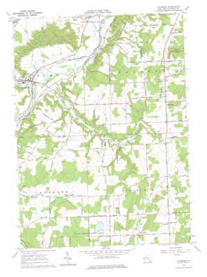
Fillmore Topo Map New York
To zoom in, hover over the map of Fillmore
USGS Topo Quad 42078d1 - 1:24,000 scale
| Topo Map Name: | Fillmore |
| USGS Topo Quad ID: | 42078d1 |
| Print Size: | ca. 21 1/4" wide x 27" high |
| Southeast Coordinates: | 42.375° N latitude / 78° W longitude |
| Map Center Coordinates: | 42.4375° N latitude / 78.0625° W longitude |
| U.S. State: | NY |
| Filename: | o42078d1.jpg |
| Download Map JPG Image: | Fillmore topo map 1:24,000 scale |
| Map Type: | Topographic |
| Topo Series: | 7.5´ |
| Map Scale: | 1:24,000 |
| Source of Map Images: | United States Geological Survey (USGS) |
| Alternate Map Versions: |
Fillmore NY 1964, updated 1965 Download PDF Buy paper map Fillmore NY 1964, updated 1976 Download PDF Buy paper map Fillmore NY 2010 Download PDF Buy paper map Fillmore NY 2013 Download PDF Buy paper map Fillmore NY 2016 Download PDF Buy paper map |
1:24,000 Topo Quads surrounding Fillmore
> Back to 42078a1 at 1:100,000 scale
> Back to 42078a1 at 1:250,000 scale
> Back to U.S. Topo Maps home
Fillmore topo map: Gazetteer
Fillmore: Bridges
Rush Creek Bridge elevation 375m 1230′Fillmore: Parks
Hank Miller Memorial Field elevation 357m 1171′Fillmore: Populated Places
Allen Center elevation 614m 2014′Fillmore elevation 365m 1197′
Rossburg elevation 354m 1161′
Short Tract elevation 495m 1624′
West Allen elevation 514m 1686′
Fillmore: Streams
Cold Creek elevation 351m 1151′Rush Creek elevation 350m 1148′
Wiscoy Creek elevation 345m 1131′
Fillmore digital topo map on disk
Buy this Fillmore topo map showing relief, roads, GPS coordinates and other geographical features, as a high-resolution digital map file on DVD:


