Chautauqua Topo Map New York
To zoom in, hover over the map of Chautauqua
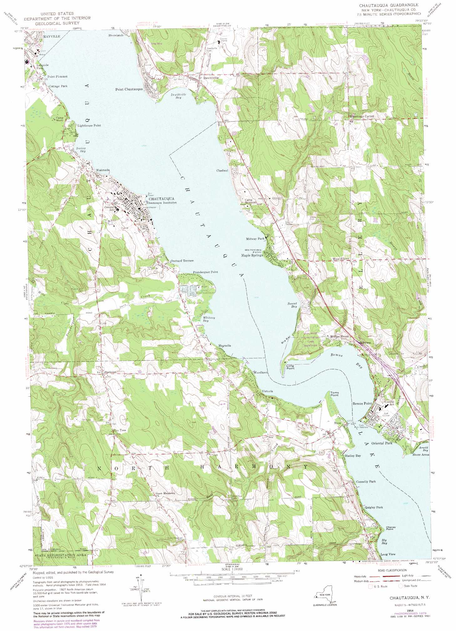
USGS Topo Quad 42079b4 - 1:24,000 scale
| Topo Map Name: | Chautauqua |
| USGS Topo Quad ID: | 42079b4 |
| Print Size: | ca. 21 1/4" wide x 27" high |
| Southeast Coordinates: | 42.125° N latitude / 79.375° W longitude |
| Map Center Coordinates: | 42.1875° N latitude / 79.4375° W longitude |
| U.S. State: | NY |
| Filename: | o42079b4.jpg |
| Download Map JPG Image: | Chautauqua topo map 1:24,000 scale |
| Map Type: | Topographic |
| Topo Series: | 7.5´ |
| Map Scale: | 1:24,000 |
| Source of Map Images: | United States Geological Survey (USGS) |
| Alternate Map Versions: |
Chautauqua NY 1954, updated 1956 Download PDF Buy paper map Chautauqua NY 1954, updated 1969 Download PDF Buy paper map Chautauqua NY 1954, updated 1979 Download PDF Buy paper map Chautauqua NY 2010 Download PDF Buy paper map Chautauqua NY 2013 Download PDF Buy paper map Chautauqua NY 2016 Download PDF Buy paper map |
1:24,000 Topo Quads surrounding Chautauqua
Brocton |
Dunkirk |
Forestville |
||
Ripley |
Westfield |
Hartfield |
Cassadaga |
Hamlet |
South Ripley |
Sherman |
Chautauqua |
Ellery Center |
Gerry |
Clymer |
North Clymer |
Panama |
Lakewood |
Jamestown |
Corry |
Columbus |
Lottsville |
Sugar Grove |
Russell |
> Back to 42079a1 at 1:100,000 scale
> Back to 42078a1 at 1:250,000 scale
> Back to U.S. Topo Maps home
Chautauqua topo map: Gazetteer
Chautauqua: Airports
Walker Seaplane Base elevation 401m 1315′Chautauqua: Bars
Big Bar elevation 399m 1309′Chautauqua: Bays
Bemus Bay elevation 399m 1309′Bly Bay elevation 399m 1309′
Dewittville Bay elevation 399m 1309′
Irwins Bay elevation 399m 1309′
Sunset Bay elevation 399m 1309′
Whitney Bay elevation 399m 1309′
Chautauqua: Capes
Cheney Point elevation 399m 1309′Lighthouse Point elevation 399m 1309′
Long Point elevation 400m 1312′
Point Chautauqua elevation 399m 1309′
Toms Point elevation 399m 1309′
Whitesides Point elevation 399m 1309′
Chautauqua: Lakes
Chautauqua Lake elevation 399m 1309′Chautauqua: Parks
Village Park elevation 401m 1315′Chautauqua: Populated Places
Bayview elevation 421m 1381′Bemus Point elevation 403m 1322′
Chautauqua elevation 415m 1361′
Chedwel elevation 407m 1335′
Connelly Park elevation 401m 1315′
Cottage Park elevation 401m 1315′
Dewittville elevation 404m 1325′
Elm Tree elevation 485m 1591′
Hadley Bay elevation 401m 1315′
Lakeside Park elevation 403m 1322′
Magnolia elevation 401m 1315′
Maple Springs elevation 400m 1312′
Midway Park elevation 402m 1318′
Orchard Terrace elevation 409m 1341′
Oriental Park elevation 403m 1322′
Point Pleasant elevation 400m 1312′
Prendergast Point elevation 400m 1312′
Quigley Park elevation 402m 1318′
Shore Acres elevation 399m 1309′
Shorelands elevation 403m 1322′
Stedman elevation 469m 1538′
Stow elevation 400m 1312′
Victoria elevation 412m 1351′
Wahmeda elevation 412m 1351′
Waterman Corner elevation 492m 1614′
West Ellery elevation 488m 1601′
Willow Brook elevation 419m 1374′
Woodlawn elevation 400m 1312′
Chautauqua: Streams
Ball Creek elevation 399m 1309′Bemus Creek elevation 415m 1361′
Browns Creek elevation 411m 1348′
Dewittville Creek elevation 399m 1309′
Prendergast Creek elevation 399m 1309′
Wing Creek elevation 409m 1341′
Chautauqua digital topo map on disk
Buy this Chautauqua topo map showing relief, roads, GPS coordinates and other geographical features, as a high-resolution digital map file on DVD:
 map DVD")