Erie North Topo Map Pennsylvania
To zoom in, hover over the map of Erie North
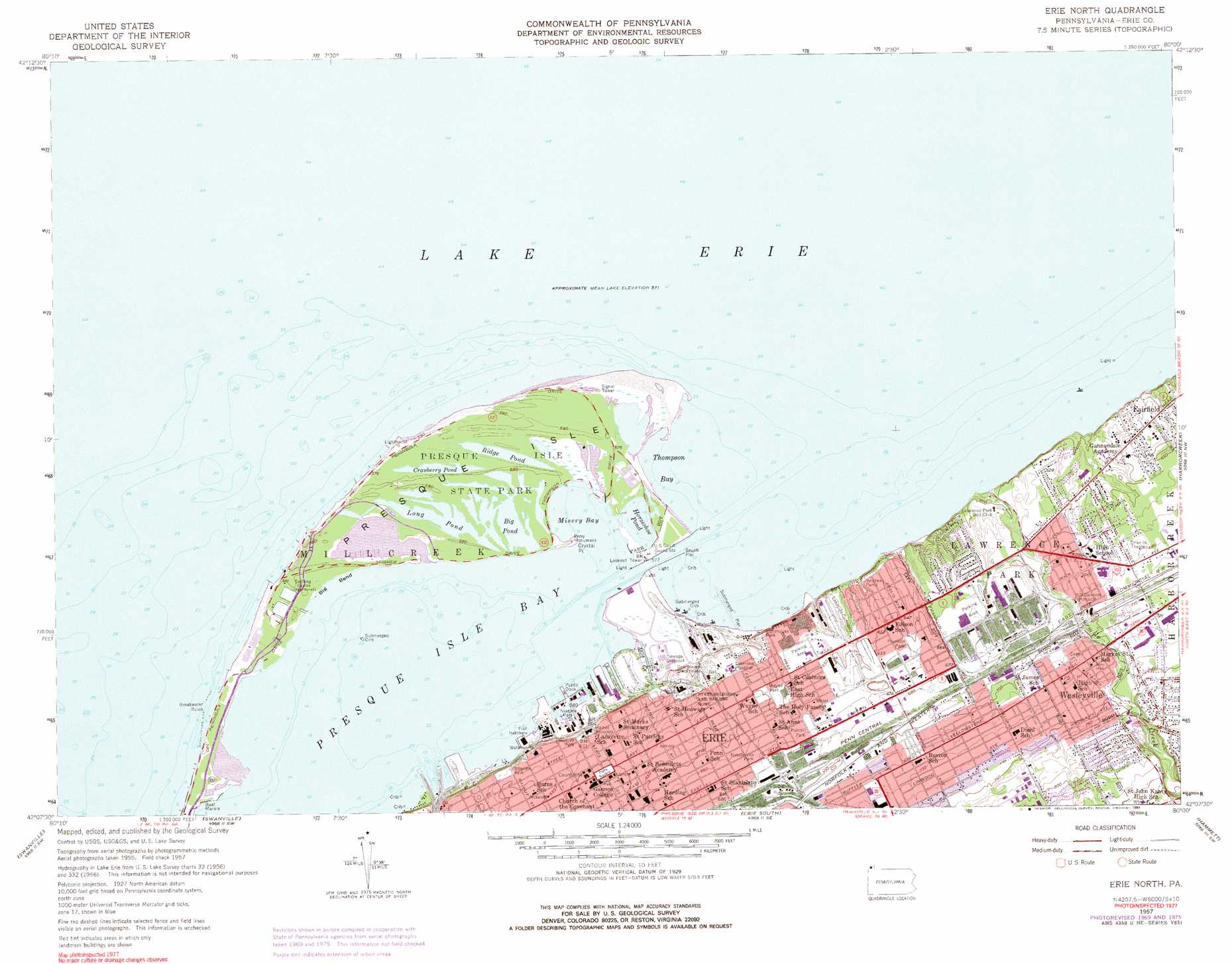
USGS Topo Quad 42080b1 - 1:24,000 scale
| Topo Map Name: | Erie North |
| USGS Topo Quad ID: | 42080b1 |
| Print Size: | ca. 21 1/4" wide x 27" high |
| Southeast Coordinates: | 42.125° N latitude / 80° W longitude |
| Map Center Coordinates: | 42.1875° N latitude / 80.0625° W longitude |
| U.S. State: | PA |
| Filename: | o42080b1.jpg |
| Download Map JPG Image: | Erie North topo map 1:24,000 scale |
| Map Type: | Topographic |
| Topo Series: | 7.5´ |
| Map Scale: | 1:24,000 |
| Source of Map Images: | United States Geological Survey (USGS) |
| Alternate Map Versions: |
Erie North PA 2010 Download PDF Buy paper map Erie North PA 2013 Download PDF Buy paper map Erie North PA 2016 Download PDF Buy paper map |
1:24,000 Topo Quads surrounding Erie North
Erie North |
Harborcreek |
North East |
||
Fairview |
Swanville |
Erie South |
Hammett |
Wattsburg |
Albion |
Edinboro North |
Cambridge Springs Ne |
Waterford |
Union City |
> Back to 42080a1 at 1:100,000 scale
> Back to 42080a1 at 1:250,000 scale
> Back to U.S. Topo Maps home
Erie North topo map: Gazetteer
Erie North: Airports
Hamot Medical Center Airport elevation 193m 633′Erie North: Bays
Misery Bay elevation 174m 570′Thompson Bay elevation 174m 570′
Erie North: Capes
Crystal Point elevation 177m 580′Presque Isle elevation 177m 580′
Erie North: Channels
Erie Harbor Entrance Channel elevation 174m 570′Erie North: Harbors
Approach Turning elevation 174m 570′Approach Turning Basin elevation 174m 570′
Eire Turning Basin elevation 174m 570′
Erie Turning Basin elevation 174m 570′
Harbor Basin elevation 174m 570′
Harbor Basin elevation 174m 570′
Harbor Turning Basin elevation 174m 570′
Harbor Turning Basin elevation 174m 570′
Erie North: Lakes
Big Pond elevation 174m 570′Cranberry Pond elevation 175m 574′
Horseshoe Pond elevation 174m 570′
Long Pond elevation 174m 570′
Niagara Pond elevation 175m 574′
Ridge Pond elevation 175m 574′
Erie North: Parks
Andrews Parks elevation 188m 616′Bayview Park elevation 195m 639′
Franklin Park elevation 200m 656′
Kosciuszko Park elevation 205m 672′
Lakeside Park elevation 187m 613′
Lighthouse Park elevation 193m 633′
Niagara Park elevation 183m 600′
Perry Monument elevation 177m 580′
Presque Isle State Park elevation 177m 580′
Pulaski Park elevation 203m 666′
Wayne Park elevation 198m 649′
Erie North: Populated Places
Erie elevation 199m 652′Fairfield elevation 190m 623′
Lawrence Park elevation 198m 649′
Wesleyville elevation 220m 721′
Erie North: Streams
Fourmile Creek elevation 174m 570′Mill Creek elevation 177m 580′
West Branch Cascade Creek elevation 176m 577′
Erie North digital topo map on disk
Buy this Erie North topo map showing relief, roads, GPS coordinates and other geographical features, as a high-resolution digital map file on DVD:
 map DVD")