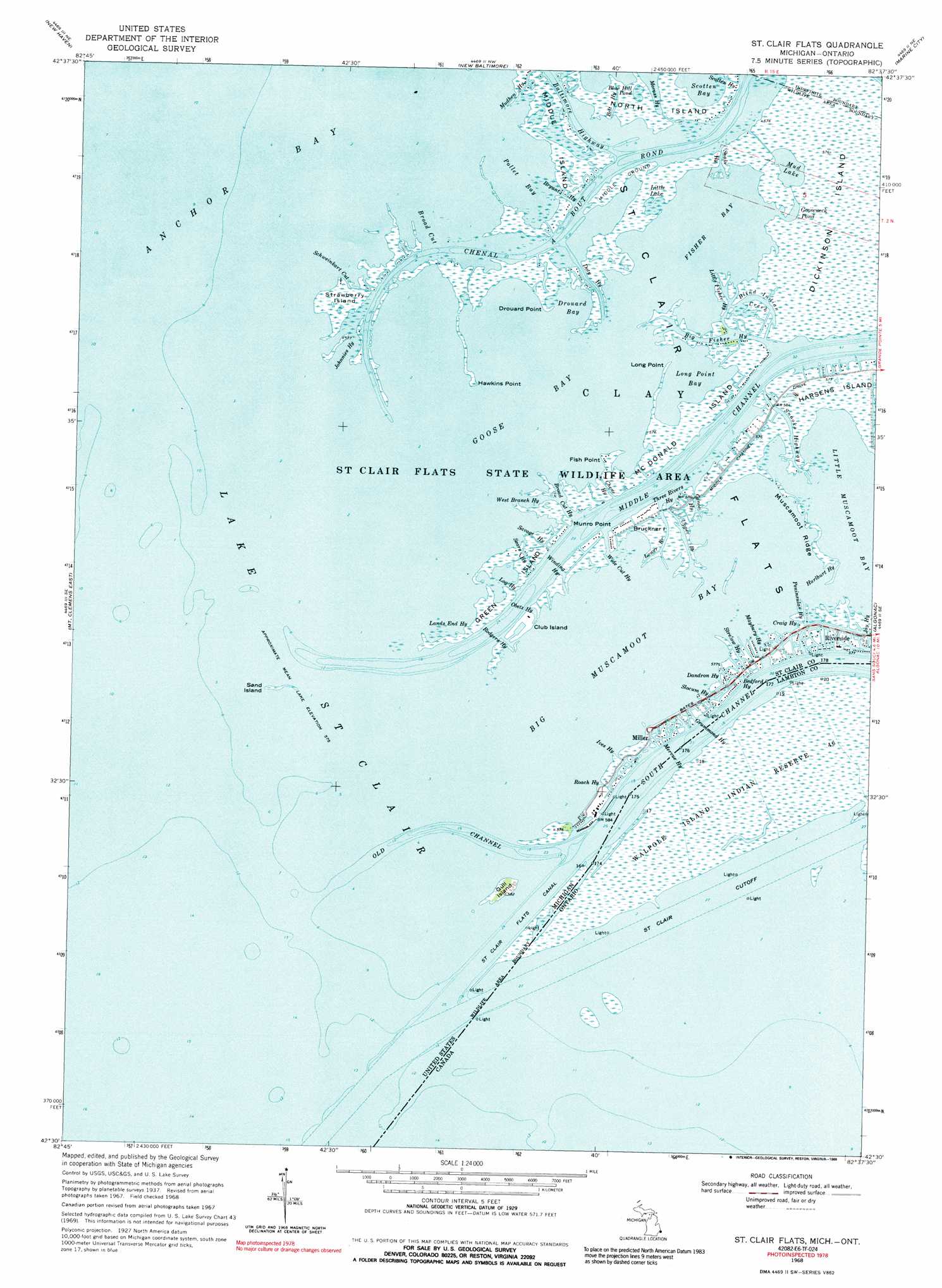
Saint Clair Flats Topo Map Michigan
To zoom in, hover over the map of Saint Clair Flats
USGS Topo Quad 42082e6 - 1:24,000 scale
| Topo Map Name: | Saint Clair Flats |
| USGS Topo Quad ID: | 42082e6 |
| Print Size: | ca. 21 1/4" wide x 27" high |
| Southeast Coordinates: | 42.5° N latitude / 82.625° W longitude |
| Map Center Coordinates: | 42.5625° N latitude / 82.6875° W longitude |
| U.S. State: | MI |
| Filename: | o42082e6.jpg |
| Download Map JPG Image: | Saint Clair Flats topo map 1:24,000 scale |
| Map Type: | Topographic |
| Topo Series: | 7.5´ |
| Map Scale: | 1:24,000 |
| Source of Map Images: | United States Geological Survey (USGS) |
| Alternate Map Versions: |
St. Clair Flats MI 1939 Download PDF Buy paper map St. Clair Flats MI 1949 Download PDF Buy paper map St. Clair Flats MI 1952, updated 1954 Download PDF Buy paper map St. Clair Flats MI 1968, updated 1971 Download PDF Buy paper map St. Clair Flats MI 1968, updated 1989 Download PDF Buy paper map Saint Clair Flats MI 2011 Download PDF Buy paper map Saint Clair Flats MI 2014 Download PDF Buy paper map Saint Clair Flats MI 2017 Download PDF Buy paper map |
1:24,000 Topo Quads surrounding Saint Clair Flats
Armada |
Richmond |
Adair |
Rattle Run |
Saint Clair |
Waldenburg |
New Haven |
New Baltimore |
Marine City |
|
Mount Clemens West |
Mount Clemens East |
Saint Clair Flats |
Algonac |
|
Grosse Pointe |
||||
Belle Isle |
> Back to 42082e1 at 1:100,000 scale
> Back to 42082a1 at 1:250,000 scale
> Back to U.S. Topo Maps home
Saint Clair Flats topo map: Gazetteer
Saint Clair Flats: Bays
Big Muscamoot Bay elevation 175m 574′Drouard Bay elevation 175m 574′
Fisher Bay elevation 175m 574′
Goose Bay elevation 175m 574′
Little Muscamoot Bay elevation 175m 574′
Long Point Bay elevation 175m 574′
Pollet Bay elevation 175m 574′
Scotten Bay elevation 175m 574′
Saint Clair Flats: Canals
Saint Clair Flats Canal elevation 175m 574′Saint Clair Flats: Capes
Drouard Point elevation 176m 577′Fish Point elevation 176m 577′
Hawkins Point elevation 177m 580′
Long Point elevation 176m 577′
Munro Point elevation 177m 580′
Saint Clair Flats: Channels
Baltimore Highway elevation 175m 574′Bedford Highway elevation 176m 577′
Belt Highway elevation 176m 577′
Big Fisher Highway elevation 175m 574′
Blind Indian Creek elevation 175m 574′
Broad Cut elevation 175m 574′
Broad Cut Highway elevation 175m 574′
Bryant Highway elevation 176m 577′
Canoe Highway elevation 177m 580′
Chenal A Bout Rond elevation 175m 574′
Chene Highway elevation 177m 580′
Craig Highway elevation 178m 583′
Dandron Highway elevation 177m 580′
Doty Highway elevation 176m 577′
Grummond Highway elevation 177m 580′
Hurlburt Highway elevation 176m 577′
Ives Highway elevation 176m 577′
Johnnies Highway elevation 175m 574′
Joy Highway elevation 177m 580′
Lands End Highway elevation 177m 580′
Little Fisher Highway elevation 176m 577′
Log Highway elevation 176m 577′
Maybury Highway elevation 175m 574′
Mervue Highway elevation 177m 580′
Moross Highway elevation 176m 577′
Mudhen Highway elevation 176m 577′
Obetz Highway elevation 176m 577′
Old Channel elevation 175m 574′
Peninsular Highway elevation 177m 580′
Roach Highway elevation 176m 577′
Rodgers Highway elevation 176m 577′
Savage Highway elevation 176m 577′
Schweinkart Cut elevation 175m 574′
Scotten Highway elevation 176m 577′
Sears Highway elevation 176m 577′
Slocum Highway elevation 175m 574′
Snake Highway elevation 175m 574′
Snooks Highway elevation 175m 574′
South Channel Saint Clair River elevation 175m 574′
Strelow Highway elevation 175m 574′
Three Rivers Highway elevation 175m 574′
West Branch Highway elevation 175m 574′
Wide Cut Highway elevation 175m 574′
Winding Highway elevation 175m 574′
Saint Clair Flats: Flats
Saint Clair Flats elevation 176m 577′Saint Clair Flats: Guts
Lower Branch elevation 177m 580′Upper Branch elevation 175m 574′
Saint Clair Flats: Islands
Bruckner Island elevation 177m 580′Club Island elevation 176m 577′
Dickinson Island elevation 176m 577′
Green Island elevation 177m 580′
Gull Island elevation 177m 580′
McDonald Island elevation 176m 577′
Middle Island elevation 175m 574′
Muscamoot Ridge elevation 178m 583′
North Island elevation 176m 577′
Sand Island elevation 176m 577′
Strawberry Island elevation 176m 577′
Saint Clair Flats: Lakes
Blue Hill Pond elevation 175m 574′Gooseneck Pond elevation 175m 574′
Little Lake elevation 175m 574′
Mud Lake elevation 175m 574′
Saint Clair Flats: Populated Places
Miller elevation 177m 580′Riverside elevation 177m 580′
Saint Clair Flats: Streams
Middle Channel Saint Clair River elevation 175m 574′Saint Clair River elevation 175m 574′
Saint Clair Flats: Swamps
Middle Ground elevation 176m 577′Saint Clair Flats digital topo map on disk
Buy this Saint Clair Flats topo map showing relief, roads, GPS coordinates and other geographical features, as a high-resolution digital map file on DVD:
 map DVD")