Smiths Creek Topo Map Michigan
To zoom in, hover over the map of Smiths Creek
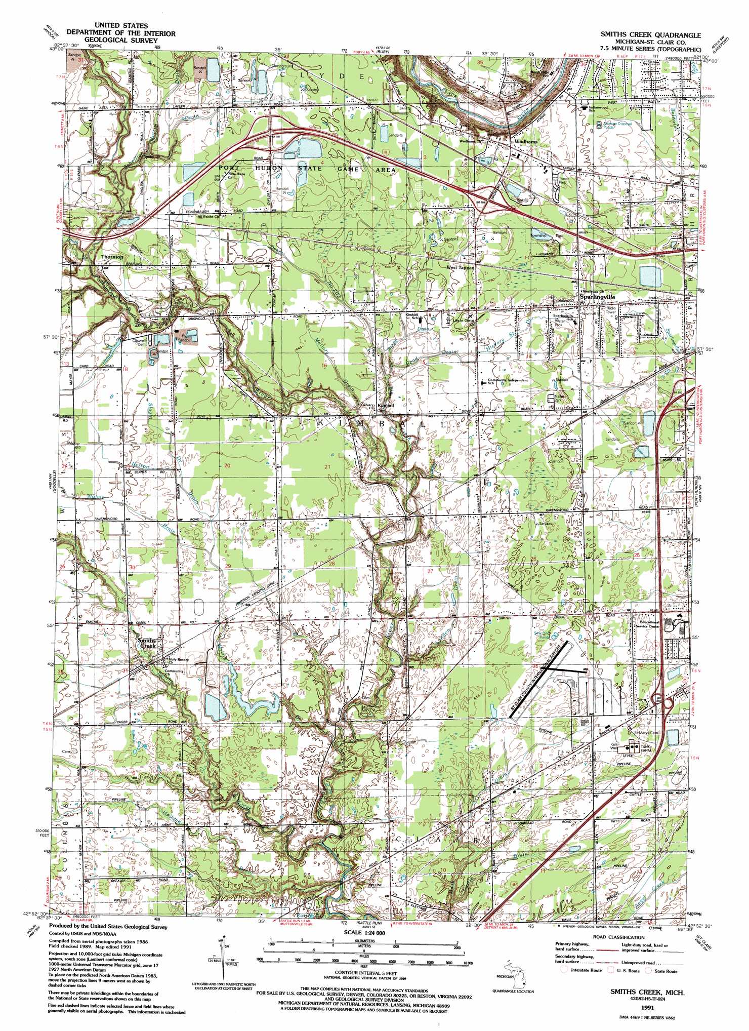
USGS Topo Quad 42082h5 - 1:24,000 scale
| Topo Map Name: | Smiths Creek |
| USGS Topo Quad ID: | 42082h5 |
| Print Size: | ca. 21 1/4" wide x 27" high |
| Southeast Coordinates: | 42.875° N latitude / 82.5° W longitude |
| Map Center Coordinates: | 42.9375° N latitude / 82.5625° W longitude |
| U.S. State: | MI |
| Filename: | o42082h5.jpg |
| Download Map JPG Image: | Smiths Creek topo map 1:24,000 scale |
| Map Type: | Topographic |
| Topo Series: | 7.5´ |
| Map Scale: | 1:24,000 |
| Source of Map Images: | United States Geological Survey (USGS) |
| Alternate Map Versions: |
Smiths Creek MI 1939 Download PDF Buy paper map Smiths Creek MI 1952, updated 1954 Download PDF Buy paper map Smiths Creek MI 1968, updated 1970 Download PDF Buy paper map Smiths Creek MI 1968, updated 1974 Download PDF Buy paper map Smiths Creek MI 1991, updated 1991 Download PDF Buy paper map Smiths Creek MI 2011 Download PDF Buy paper map Smiths Creek MI 2014 Download PDF Buy paper map Smiths Creek MI 2017 Download PDF Buy paper map |
1:24,000 Topo Quads surrounding Smiths Creek
Yale |
Roseburg |
Jeddo |
||
Brockway |
Avoca |
Ruby |
Lakeport |
|
Memphis |
Goodells |
Smiths Creek |
Port Huron |
|
Richmond |
Adair |
Rattle Run |
Saint Clair |
|
New Haven |
New Baltimore |
Marine City |
> Back to 42082e1 at 1:100,000 scale
> Back to 42082a1 at 1:250,000 scale
> Back to U.S. Topo Maps home
Smiths Creek topo map: Gazetteer
Smiths Creek: Airports
Johnson Field elevation 192m 629′Saint Clair County International Airport elevation 196m 643′
Smiths Creek: Canals
Burdie Drain elevation 196m 643′Cuttle Drain elevation 190m 623′
Drain Number Two Hundred Two elevation 196m 643′
Hickory Street Drain elevation 199m 652′
London Drain elevation 193m 633′
Mallory Drain elevation 193m 633′
Read Drain elevation 196m 643′
Slaght Drain elevation 196m 643′
Sparlingville Drain elevation 191m 626′
Smiths Creek: Crossings
Interchange 194 elevation 206m 675′Interchange 196 elevation 203m 666′
Interchange 266 elevation 199m 652′
Interchange 269 elevation 192m 629′
Smiths Creek: Lakes
Crystal Lake elevation 204m 669′Pine Lake elevation 204m 669′
Trent Lake elevation 205m 672′
Smiths Creek: Parks
Kimball Township Park elevation 202m 662′Kimball Township Park elevation 202m 662′
Smiths Creek: Populated Places
Kimball elevation 194m 636′Smiths Creek elevation 193m 633′
Somerset Meadows Mobile Home Park elevation 198m 649′
Sparlingville elevation 199m 652′
The Lakes Mobile Home Park elevation 205m 672′
Thornton elevation 200m 656′
Wadhams elevation 204m 669′
West Tappan elevation 202m 662′
Smiths Creek: Post Offices
Burns Post Office (historical) elevation 201m 659′Kimball Post Office (historical) elevation 194m 636′
Smiths Creek Post Office elevation 194m 636′
Thornton Post Office (historical) elevation 200m 656′
Wadhams Post Office (historical) elevation 204m 669′
Smiths Creek: Streams
Alpine Drain elevation 186m 610′Big Creek elevation 185m 606′
Holland Drain elevation 181m 593′
Liverance Drain elevation 191m 626′
Morris Drain elevation 196m 643′
Nelson Drain elevation 192m 629′
Rattle Run elevation 177m 580′
Scheffle Drain elevation 193m 633′
Smiths Creek elevation 179m 587′
South Branch Pine River elevation 193m 633′
Wolvin Drain elevation 182m 597′
Smiths Creek digital topo map on disk
Buy this Smiths Creek topo map showing relief, roads, GPS coordinates and other geographical features, as a high-resolution digital map file on DVD:
 map DVD")