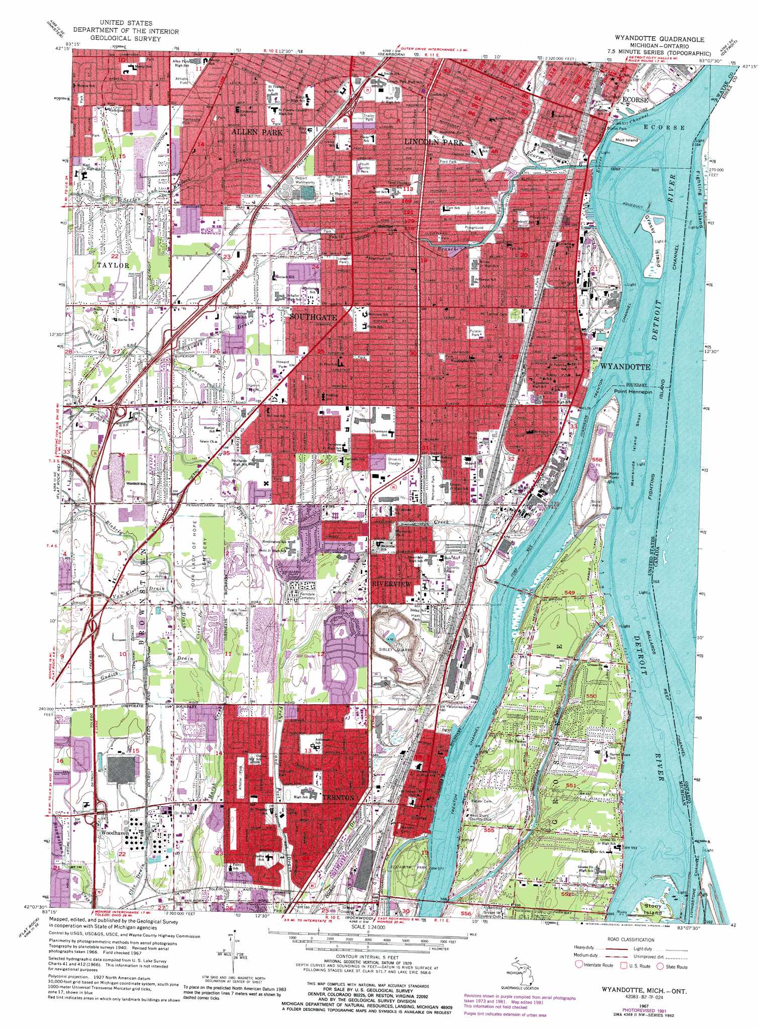
Wyandotte Topo Map Michigan
To zoom in, hover over the map of Wyandotte
USGS Topo Quad 42083b2 - 1:24,000 scale
| Topo Map Name: | Wyandotte |
| USGS Topo Quad ID: | 42083b2 |
| Print Size: | ca. 21 1/4" wide x 27" high |
| Southeast Coordinates: | 42.125° N latitude / 83.125° W longitude |
| Map Center Coordinates: | 42.1875° N latitude / 83.1875° W longitude |
| U.S. State: | MI |
| Filename: | o42083b2.jpg |
| Download Map JPG Image: | Wyandotte topo map 1:24,000 scale |
| Map Type: | Topographic |
| Topo Series: | 7.5´ |
| Map Scale: | 1:24,000 |
| Source of Map Images: | United States Geological Survey (USGS) |
| Alternate Map Versions: |
Wyandotte MI 1952, updated 1954 Download PDF Buy paper map Wyandotte MI 1967, updated 1969 Download PDF Buy paper map Wyandotte MI 1967, updated 1974 Download PDF Buy paper map Wyandotte MI 1967, updated 1981 Download PDF Buy paper map Wyandotte MI 1967, updated 1989 Download PDF Buy paper map Wyandotte MI 2011 Download PDF Buy paper map Wyandotte MI 2014 Download PDF Buy paper map Wyandotte MI 2017 Download PDF Buy paper map |
1:24,000 Topo Quads surrounding Wyandotte
Northville |
Redford |
Royal Oak |
Highland Park |
Grosse Pointe |
Wayne |
Inkster |
Dearborn |
Detroit |
Belle Isle |
Belleville |
Flat Rock Ne |
Wyandotte |
||
Carleton |
Flat Rock |
Rockwood |
||
Monroe |
Stony Point |
Estral Beach |
> Back to 42083a1 at 1:100,000 scale
> Back to 42082a1 at 1:250,000 scale
> Back to U.S. Topo Maps home
Wyandotte topo map: Gazetteer
Wyandotte: Airports
General Hospital Heliport elevation 174m 570′Wyandotte: Bars
Mamajuda Island Shoal elevation 174m 570′Wyandotte: Canals
Bondie Drain elevation 183m 600′Thorofare Canal elevation 174m 570′
Wyandotte: Capes
Point Hennepin elevation 175m 574′Wyandotte: Channels
Ballards Channel elevation 174m 570′Ecorse Channel elevation 174m 570′
Fighting Island Channel elevation 174m 570′
Trenton Channel elevation 174m 570′
Wyandotte: Islands
Grassy Island elevation 175m 574′Grosse Ile elevation 181m 593′
Mamajuda Island elevation 174m 570′
Mud Island elevation 180m 590′
Stony Island elevation 176m 577′
Wyandotte: Mines
Sibley Quarry elevation 149m 488′Wyandotte: Parks
Affolter Park elevation 181m 593′Bishop Park elevation 176m 577′
Cherry Park elevation 177m 580′
Ecorse Park elevation 176m 577′
Elizabeth Park elevation 179m 587′
Ford Park elevation 178m 583′
Haas Park elevation 185m 606′
Howard Park elevation 182m 597′
Kennedy Park elevation 177m 580′
LaBlanc Field elevation 177m 580′
McLouth Park elevation 177m 580′
Panhandle Park elevation 183m 600′
Pulaski Park elevation 177m 580′
Vreeland Park elevation 176m 577′
Wyandotte National Wildlife Refuge elevation 175m 574′
Youth Center Park elevation 179m 587′
Wyandotte: Populated Places
Ecorse elevation 177m 580′Grosse Ile elevation 182m 597′
Riverview elevation 183m 600′
Sibley elevation 183m 600′
Southgate elevation 180m 590′
Trenton elevation 182m 597′
Woodhaven elevation 184m 603′
Wyandotte elevation 177m 580′
Wyandotte: Post Offices
Grosse Isle Post Office elevation 181m 593′Southgate Post Office elevation 181m 593′
Wyandotte: Streams
Asmey Drain elevation 181m 593′Blakely Drain elevation 179m 587′
Brighton Drain elevation 181m 593′
Clark Drain elevation 179m 587′
Ecorse River elevation 174m 570′
Gudith Drain elevation 179m 587′
Huntington Creek elevation 174m 570′
Sexton and Kilfoil Drain elevation 177m 580′
South Branch Ecorse River elevation 174m 570′
Sutliff and Kenope Drain elevation 179m 587′
Van Kleef Drain elevation 179m 587′
Wyandotte digital topo map on disk
Buy this Wyandotte topo map showing relief, roads, GPS coordinates and other geographical features, as a high-resolution digital map file on DVD:
 map DVD")