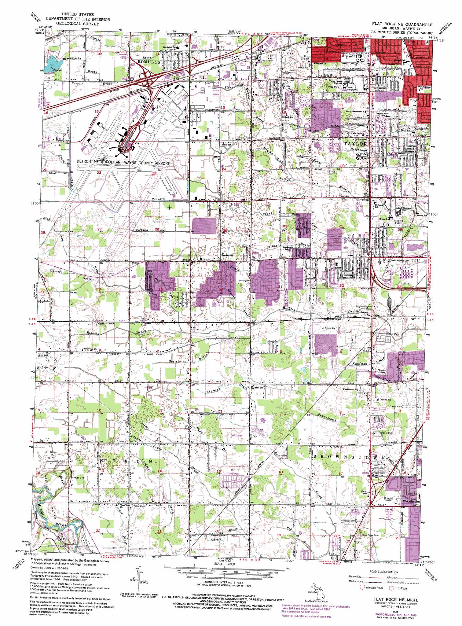
Flat Rock Ne Topo Map Michigan
To zoom in, hover over the map of Flat Rock Ne
USGS Topo Quad 42083b3 - 1:24,000 scale
| Topo Map Name: | Flat Rock Ne |
| USGS Topo Quad ID: | 42083b3 |
| Print Size: | ca. 21 1/4" wide x 27" high |
| Southeast Coordinates: | 42.125° N latitude / 83.25° W longitude |
| Map Center Coordinates: | 42.1875° N latitude / 83.3125° W longitude |
| U.S. State: | MI |
| Filename: | o42083b3.jpg |
| Download Map JPG Image: | Flat Rock Ne topo map 1:24,000 scale |
| Map Type: | Topographic |
| Topo Series: | 7.5´ |
| Map Scale: | 1:24,000 |
| Source of Map Images: | United States Geological Survey (USGS) |
| Alternate Map Versions: |
Wayne Co Airport MI 1942 Download PDF Buy paper map Detroit Wayne Airport MI 1952, updated 1954 Download PDF Buy paper map Flat Rock NE MI 1967, updated 1969 Download PDF Buy paper map Flat Rock NE MI 1967, updated 1974 Download PDF Buy paper map Flat Rock NE MI 1967, updated 1981 Download PDF Buy paper map Flat Rock NE MI 2011 Download PDF Buy paper map Flat Rock NE MI 2014 Download PDF Buy paper map Flat Rock NE MI 2017 Download PDF Buy paper map |
1:24,000 Topo Quads surrounding Flat Rock Ne
Salem |
Northville |
Redford |
Royal Oak |
Highland Park |
Denton |
Wayne |
Inkster |
Dearborn |
Detroit |
Ypsilanti East |
Belleville |
Flat Rock Ne |
Wyandotte |
|
Maybee |
Carleton |
Flat Rock |
Rockwood |
|
Ida |
Monroe |
Stony Point |
Estral Beach |
> Back to 42083a1 at 1:100,000 scale
> Back to 42082a1 at 1:250,000 scale
> Back to U.S. Topo Maps home
Flat Rock Ne topo map: Gazetteer
Flat Rock Ne: Airports
Detroit Metropolitan Wayne County Airport elevation 193m 633′Flat Rock Ne: Parks
Capital Park elevation 186m 610′Frazier Park elevation 187m 613′
Papp Park elevation 189m 620′
Flat Rock Ne: Populated Places
Taylor elevation 187m 613′Taylor Center elevation 187m 613′
Flat Rock Ne: Streams
Adams Drain elevation 187m 613′Batham Drain elevation 192m 629′
Carter Drain elevation 190m 623′
English Drain elevation 187m 613′
Freeman Drain elevation 192m 629′
Goetske Drain elevation 187m 613′
Hale Creek elevation 187m 613′
Hale Drain elevation 183m 600′
Hand Drain elevation 186m 610′
Hand Drain elevation 184m 603′
Harris Drain elevation 188m 616′
Hubert Drain elevation 192m 629′
Jacques Drain elevation 189m 620′
Kaufman Drain elevation 183m 600′
Mizner Drain elevation 185m 606′
New Otting Drain elevation 184m 603′
Odette Drain elevation 184m 603′
Packard Drain elevation 190m 623′
Packard Drain elevation 186m 610′
Poet Drain elevation 189m 620′
Rawson Drain elevation 193m 633′
Regan Drain elevation 186m 610′
Reh Drain elevation 183m 600′
Reiser Drain elevation 192m 629′
Rosenworth Drain elevation 193m 633′
Sherman Drain elevation 187m 613′
Shook Drain elevation 193m 633′
Sloss and Ganong Drain elevation 189m 620′
Snow Drain elevation 187m 613′
Texas Marsh Drain elevation 189m 620′
Vealy Drain elevation 193m 633′
Zink Drain elevation 192m 629′
Flat Rock Ne digital topo map on disk
Buy this Flat Rock Ne topo map showing relief, roads, GPS coordinates and other geographical features, as a high-resolution digital map file on DVD:
 map DVD")