Detroit Topo Map Michigan
To zoom in, hover over the map of Detroit
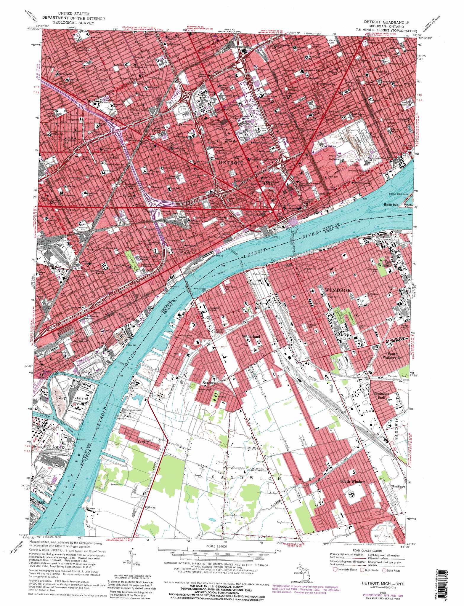
USGS Topo Quad 42083c1 - 1:24,000 scale
| Topo Map Name: | Detroit |
| USGS Topo Quad ID: | 42083c1 |
| Print Size: | ca. 21 1/4" wide x 27" high |
| Southeast Coordinates: | 42.25° N latitude / 83° W longitude |
| Map Center Coordinates: | 42.3125° N latitude / 83.0625° W longitude |
| U.S. State: | MI |
| Filename: | o42083c1.jpg |
| Download Map JPG Image: | Detroit topo map 1:24,000 scale |
| Map Type: | Topographic |
| Topo Series: | 7.5´ |
| Map Scale: | 1:24,000 |
| Source of Map Images: | United States Geological Survey (USGS) |
| Alternate Map Versions: |
Detroit MI 1940 Download PDF Buy paper map Detroit MI 1947 Download PDF Buy paper map Detroit MI 1952, updated 1954 Download PDF Buy paper map Detroit MI 1968, updated 1971 Download PDF Buy paper map Detroit MI 1968, updated 1974 Download PDF Buy paper map Detroit MI 1968, updated 1981 Download PDF Buy paper map Detroit MI 1968, updated 1981 Download PDF Buy paper map Detroit MI 2011 Download PDF Buy paper map Detroit MI 2014 Download PDF Buy paper map Detroit MI 2017 Download PDF Buy paper map |
1:24,000 Topo Quads surrounding Detroit
Pontiac South |
Birmingham |
Warren |
Mount Clemens West |
Mount Clemens East |
Redford |
Royal Oak |
Highland Park |
Grosse Pointe |
|
Inkster |
Dearborn |
Detroit |
Belle Isle |
|
Flat Rock Ne |
Wyandotte |
|||
Flat Rock |
Rockwood |
> Back to 42083a1 at 1:100,000 scale
> Back to 42082a1 at 1:250,000 scale
> Back to U.S. Topo Maps home
Detroit topo map: Gazetteer
Detroit: Airports
Cobo Hall Heliport elevation 178m 583′Detroit Medical Center Heliport elevation 192m 629′
Henry Ford Hospital Heliport elevation 192m 629′
WDIV-TV Channel 4 Heliport elevation 185m 606′
Detroit: Bridges
Ambassador Bridge elevation 174m 570′Detroit: Canals
Short Cut Canal 21 elevation 174m 570′Detroit: Islands
Zug Island elevation 177m 580′Detroit: Parks
Ames Playground elevation 187m 613′Atkinson Park elevation 183m 600′
Boyer Playground elevation 181m 593′
Bradley Playground elevation 189m 620′
Brewster Park elevation 189m 620′
Callahan Playground elevation 191m 626′
Campau Park elevation 188m 616′
Cass Park elevation 186m 610′
Central Park elevation 181m 593′
Chene Park elevation 177m 580′
Clark Park elevation 180m 590′
Comerica Park elevation 184m 603′
Dabrowski Playground elevation 192m 629′
Elton Park elevation 183m 600′
Erskine Playground elevation 189m 620′
Ewald Playground elevation 187m 613′
Fiori Playground elevation 190m 623′
Ford Field elevation 184m 603′
Gabriel Richard Park elevation 181m 593′
Garfield Playground elevation 192m 629′
Grand Circus Park elevation 183m 600′
Joe Louis Arena elevation 177m 580′
John F Kennedy Square elevation 183m 600′
La Salle Park elevation 193m 633′
Lafayette Plaisance elevation 184m 603′
Litsitz Memorial Playground elevation 193m 633′
Macomb Park elevation 183m 600′
Malish Playground elevation 181m 593′
Olympia Stadium elevation 189m 620′
Peck Park elevation 192m 629′
Perrien Park elevation 192m 629′
Riverside Park elevation 177m 580′
Roosevelt Park elevation 183m 600′
Scripps Park elevation 186m 610′
Stanton Park elevation 181m 593′
Tiger Stadium elevation 183m 600′
Tolan Park elevation 190m 623′
Vernor Playground elevation 192m 629′
Watson Playground elevation 184m 603′
Wigle Memorial Playground elevation 187m 613′
Detroit: Populated Places
Delray elevation 178m 583′Detroit elevation 183m 600′
Fort Wayne elevation 181m 593′
Detroit: Streams
River Rouge elevation 174m 570′Detroit: Tunnels
Detroit Windsor Tunnel elevation 174m 570′Detroit digital topo map on disk
Buy this Detroit topo map showing relief, roads, GPS coordinates and other geographical features, as a high-resolution digital map file on DVD:
 map DVD")