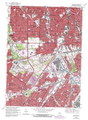
Dearborn Topo Map Michigan
To zoom in, hover over the map of Dearborn
USGS Topo Quad 42083c2 - 1:24,000 scale
| Topo Map Name: | Dearborn |
| USGS Topo Quad ID: | 42083c2 |
| Print Size: | ca. 21 1/4" wide x 27" high |
| Southeast Coordinates: | 42.25° N latitude / 83.125° W longitude |
| Map Center Coordinates: | 42.3125° N latitude / 83.1875° W longitude |
| U.S. State: | MI |
| Filename: | o42083c2.jpg |
| Download Map JPG Image: | Dearborn topo map 1:24,000 scale |
| Map Type: | Topographic |
| Topo Series: | 7.5´ |
| Map Scale: | 1:24,000 |
| Source of Map Images: | United States Geological Survey (USGS) |
| Alternate Map Versions: |
Dearborn MI 1942 Download PDF Buy paper map Dearborn MI 1942, updated 1942 Download PDF Buy paper map Dearborn MI 1952, updated 1954 Download PDF Buy paper map Dearborn MI 1968, updated 1970 Download PDF Buy paper map Dearborn MI 1968, updated 1974 Download PDF Buy paper map Dearborn MI 1968, updated 1984 Download PDF Buy paper map Dearborn MI 1968, updated 1984 Download PDF Buy paper map Dearborn MI 2011 Download PDF Buy paper map Dearborn MI 2014 Download PDF Buy paper map Dearborn MI 2017 Download PDF Buy paper map |
1:24,000 Topo Quads surrounding Dearborn
> Back to 42083a1 at 1:100,000 scale
> Back to 42082a1 at 1:250,000 scale
> Back to U.S. Topo Maps home
Dearborn topo map: Gazetteer
Dearborn: Airports
Dearborn Helistop elevation 184m 603′Fairlane Plaza Heliport elevation 183m 600′
Hyatt Regency Hotel Heliport elevation 183m 600′
Dearborn: Crossings
Interchange 204A elevation 182m 597′Interchange 204B elevation 184m 603′
Dearborn: Guts
Baby Creek elevation 175m 574′Dearborn: Islands
Fordson Island elevation 175m 574′Dearborn: Parks
Ahrens Field elevation 186m 610′Anthony Park elevation 184m 603′
Brand Park elevation 180m 590′
Coogan Park elevation 181m 593′
Cunningham Park elevation 183m 600′
De Luca Field elevation 179m 587′
Doan Playground elevation 188m 616′
Dover Park elevation 185m 606′
Ford Field elevation 177m 580′
Ford Woods Park elevation 181m 593′
Geer Park elevation 181m 593′
Green Playground elevation 187m 613′
Hemlock Park elevation 182m 597′
John F Kennedy Park elevation 182m 597′
Lapeer Park elevation 177m 580′
Loverix Park elevation 179m 587′
Nardin Park elevation 192m 629′
Patton Memorial Park elevation 177m 580′
Quandt Park elevation 179m 587′
River Rouge Park elevation 179m 587′
Rosedale Park elevation 180m 590′
Stein Playground elevation 188m 616′
Stoepel Park Number 2 elevation 188m 616′
Weiss Playground elevation 181m 593′
Wilson Playground elevation 181m 593′
Dearborn: Populated Places
Allen Park elevation 181m 593′Dearborn elevation 180m 590′
Greenfield Village elevation 182m 597′
Lincoln Park elevation 179m 587′
Melvindale elevation 179m 587′
River Rouge elevation 178m 583′
Dearborn: Post Offices
Allen Park Post Office elevation 182m 597′Dearborn Post Office elevation 180m 590′
Melvindale Post Office elevation 179m 587′
River Rouge Post Office elevation 177m 580′
Dearborn: Streams
Allen Drain elevation 180m 590′German Drain elevation 186m 610′
Lower River Rouge elevation 174m 570′
Middle River Rouge elevation 178m 583′
Reeck Drain elevation 181m 593′
Tyre Drain elevation 180m 590′
Dearborn digital topo map on disk
Buy this Dearborn topo map showing relief, roads, GPS coordinates and other geographical features, as a high-resolution digital map file on DVD:


