Highland Park Topo Map Michigan
To zoom in, hover over the map of Highland Park
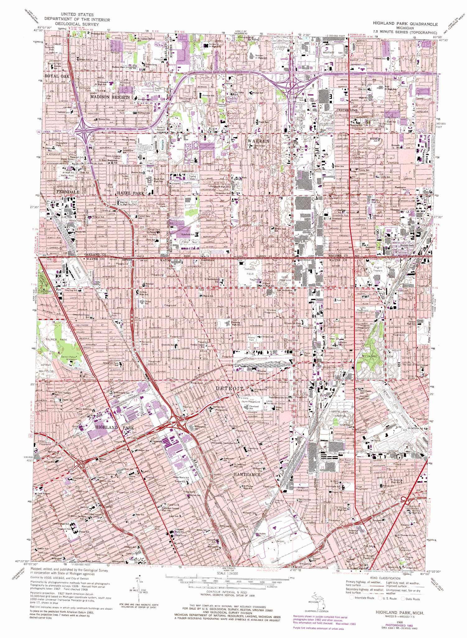
USGS Topo Quad 42083d1 - 1:24,000 scale
| Topo Map Name: | Highland Park |
| USGS Topo Quad ID: | 42083d1 |
| Print Size: | ca. 21 1/4" wide x 27" high |
| Southeast Coordinates: | 42.375° N latitude / 83° W longitude |
| Map Center Coordinates: | 42.4375° N latitude / 83.0625° W longitude |
| U.S. State: | MI |
| Filename: | o42083d1.jpg |
| Download Map JPG Image: | Highland Park topo map 1:24,000 scale |
| Map Type: | Topographic |
| Topo Series: | 7.5´ |
| Map Scale: | 1:24,000 |
| Source of Map Images: | United States Geological Survey (USGS) |
| Alternate Map Versions: |
Highland Park MI 1940 Download PDF Buy paper map Highland Park MI 1940 Download PDF Buy paper map Highland Park MI 1952, updated 1954 Download PDF Buy paper map Highland Park MI 1968, updated 1971 Download PDF Buy paper map Highland Park MI 1968, updated 1974 Download PDF Buy paper map Highland Park MI 1968, updated 1984 Download PDF Buy paper map Highland Park MI 2011 Download PDF Buy paper map Highland Park MI 2014 Download PDF Buy paper map Highland Park MI 2017 Download PDF Buy paper map |
1:24,000 Topo Quads surrounding Highland Park
Pontiac North |
Rochester |
Utica |
Waldenburg |
New Haven |
Pontiac South |
Birmingham |
Warren |
Mount Clemens West |
Mount Clemens East |
Redford |
Royal Oak |
Highland Park |
Grosse Pointe |
|
Inkster |
Dearborn |
Detroit |
Belle Isle |
|
Flat Rock Ne |
Wyandotte |
> Back to 42083a1 at 1:100,000 scale
> Back to 42082a1 at 1:250,000 scale
> Back to U.S. Topo Maps home
Highland Park topo map: Gazetteer
Highland Park: Airports
Acme Heliport elevation 190m 623′Detroit City Airport elevation 190m 623′
Highland Park: Parks
Altermatt Park elevation 190m 623′Bassett Park elevation 194m 636′
Bessy Playground elevation 189m 620′
Biraga Playground elevation 191m 626′
Butler Playfield elevation 192m 629′
Coventry Park elevation 196m 643′
Curie Park elevation 190m 623′
Dorals Playground elevation 192m 629′
Farwell Field elevation 191m 626′
Felker Field elevation 192m 629′
Fletcher Playground elevation 189m 620′
Ford Park elevation 193m 633′
Glendale Park elevation 196m 643′
Grba Field elevation 192m 629′
Green Acres Park elevation 193m 633′
Groesbeck Park elevation 190m 623′
Hazel Park Harness Raceway elevation 196m 643′
Howarth Playground elevation 189m 620′
Hunt Playground elevation 193m 633′
Ives Field elevation 195m 639′
Jayne Playground elevation 192m 629′
Karam Park elevation 192m 629′
Kennedy Park elevation 192m 629′
Kenwood Park elevation 193m 633′
Kern Playground elevation 190m 623′
Krainz Park elevation 195m 639′
Latham Playground elevation 187m 613′
Lipke Playground elevation 189m 620′
Lodge Playground elevation 192m 629′
Madge Park elevation 192m 629′
Mapledale Park elevation 193m 633′
Martin Road Park elevation 194m 636′
Molena-Castle Playground elevation 191m 626′
O'Brien Playground elevation 190m 623′
Old Varsity Field elevation 193m 633′
Palmer Park elevation 196m 643′
Peck Recreation Center elevation 195m 639′
Pingree Park elevation 187m 613′
Saint Anthony Playground elevation 190m 623′
Saint Clements Field elevation 190m 623′
Schuster Playground elevation 192m 629′
Scout Park elevation 192m 629′
Steinhauser Park elevation 191m 626′
Sunset Park elevation 193m 633′
Syracuse Playground elevation 190m 623′
Tucker Park elevation 193m 633′
Voight Park elevation 193m 633′
Wanda Park elevation 193m 633′
Wiegand Park elevation 190m 623′
Wildwood Park elevation 193m 633′
Wilson Park elevation 194m 636′
Highland Park: Populated Places
Center Line elevation 190m 623′Hamtramck elevation 192m 629′
Hazel Park elevation 191m 626′
Highland Park elevation 194m 636′
Madison Heights elevation 193m 633′
Warren elevation 190m 623′
Highland Park: Post Offices
Hamtramck Post Office elevation 192m 629′Hazel Park Post Office elevation 192m 629′
Highland Park digital topo map on disk
Buy this Highland Park topo map showing relief, roads, GPS coordinates and other geographical features, as a high-resolution digital map file on DVD:
 map DVD")