South Lyon Topo Map Michigan
To zoom in, hover over the map of South Lyon
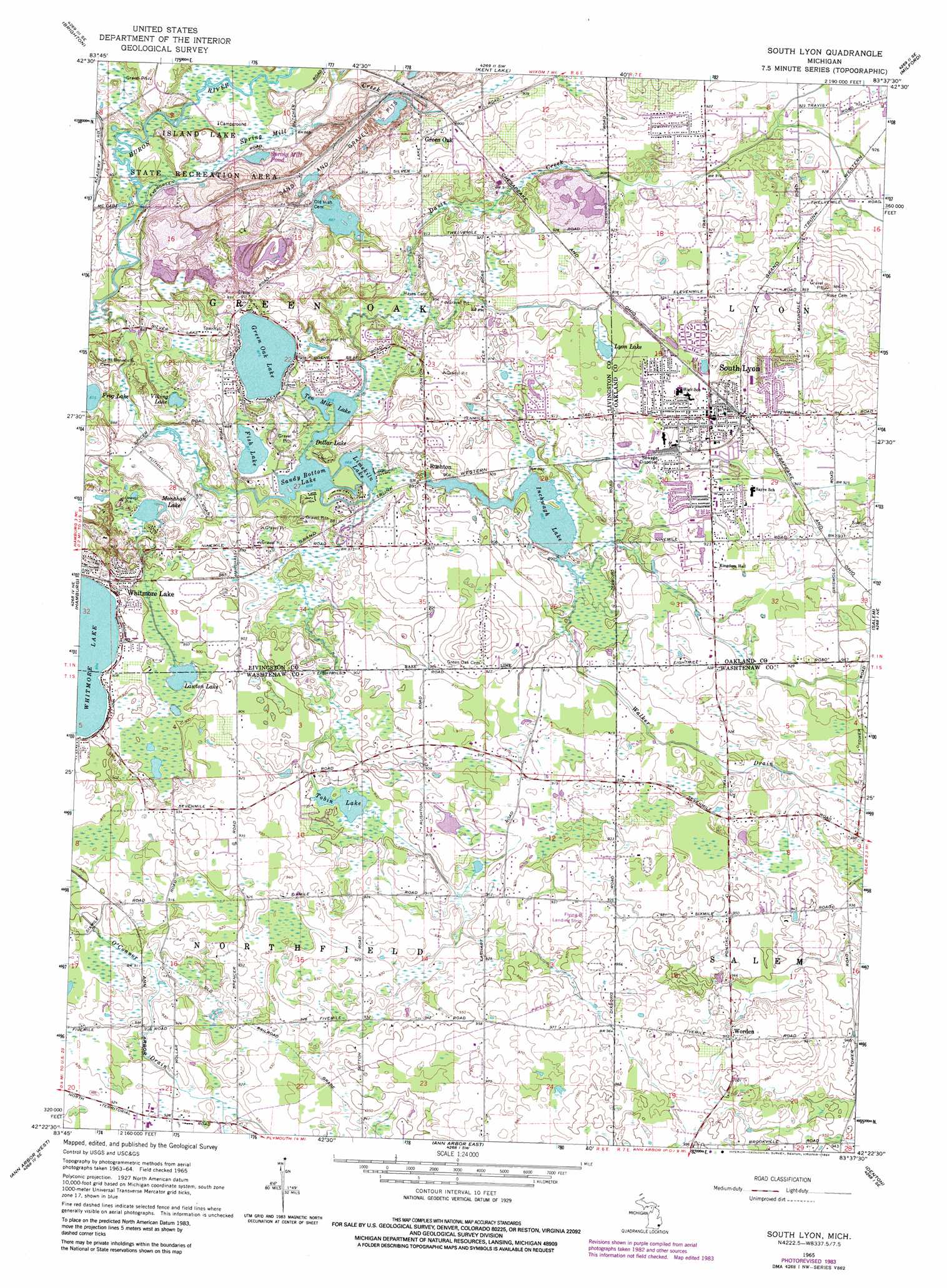
USGS Topo Quad 42083d6 - 1:24,000 scale
| Topo Map Name: | South Lyon |
| USGS Topo Quad ID: | 42083d6 |
| Print Size: | ca. 21 1/4" wide x 27" high |
| Southeast Coordinates: | 42.375° N latitude / 83.625° W longitude |
| Map Center Coordinates: | 42.4375° N latitude / 83.6875° W longitude |
| U.S. State: | MI |
| Filename: | o42083d6.jpg |
| Download Map JPG Image: | South Lyon topo map 1:24,000 scale |
| Map Type: | Topographic |
| Topo Series: | 7.5´ |
| Map Scale: | 1:24,000 |
| Source of Map Images: | United States Geological Survey (USGS) |
| Alternate Map Versions: |
South Lyon MI 1965, updated 1967 Download PDF Buy paper map South Lyon MI 1965, updated 1974 Download PDF Buy paper map South Lyon MI 1965, updated 1984 Download PDF Buy paper map South Lyon MI 1965, updated 1984 Download PDF Buy paper map South Lyon MI 2011 Download PDF Buy paper map South Lyon MI 2014 Download PDF Buy paper map South Lyon MI 2017 Download PDF Buy paper map |
1:24,000 Topo Quads surrounding South Lyon
Oak Grove |
Hartland |
West Highland |
Highland |
Clarkston |
Howell |
Brighton |
Kent Lake |
Milford |
Walled Lake |
Pinckney |
Hamburg |
South Lyon |
Salem |
Northville |
Dexter |
Ann Arbor West |
Ann Arbor East |
Denton |
Wayne |
Bridgewater |
Saline |
Ypsilanti West |
Ypsilanti East |
Belleville |
> Back to 42083a1 at 1:100,000 scale
> Back to 42082a1 at 1:250,000 scale
> Back to U.S. Topo Maps home
South Lyon topo map: Gazetteer
South Lyon: Airports
Heliflite Heliport elevation 283m 928′South Lyon: Lakes
Dollar Lake elevation 263m 862′Fish Lake elevation 265m 869′
Frog Lake elevation 267m 875′
Green Oak Lake elevation 267m 875′
Inchwagh Lake elevation 269m 882′
Lawton Lake elevation 269m 882′
Limekiln Lake elevation 263m 862′
Lyon Lake elevation 272m 892′
Mallard Lake elevation 269m 882′
Monahan Lake elevation 266m 872′
Sandy Bottom Lake elevation 263m 862′
Spring Mill Pond elevation 264m 866′
Ten Mile Lake elevation 263m 862′
Tobin Lake elevation 272m 892′
Viking Lake elevation 264m 866′
South Lyon: Parks
Island Lake State Recreation Area elevation 270m 885′South Lyon: Populated Places
Green Oak elevation 282m 925′Rushton elevation 272m 892′
South Lyon elevation 282m 925′
Whitmore Lake elevation 281m 921′
Worden elevation 297m 974′
South Lyon: Streams
Davis Creek elevation 264m 866′Spring Mill Creek elevation 261m 856′
Walker Drain elevation 275m 902′
South Lyon: Trails
Pontiac Trail elevation 281m 921′South Lyon digital topo map on disk
Buy this South Lyon topo map showing relief, roads, GPS coordinates and other geographical features, as a high-resolution digital map file on DVD:
 map DVD")