Walled Lake Topo Map Michigan
To zoom in, hover over the map of Walled Lake
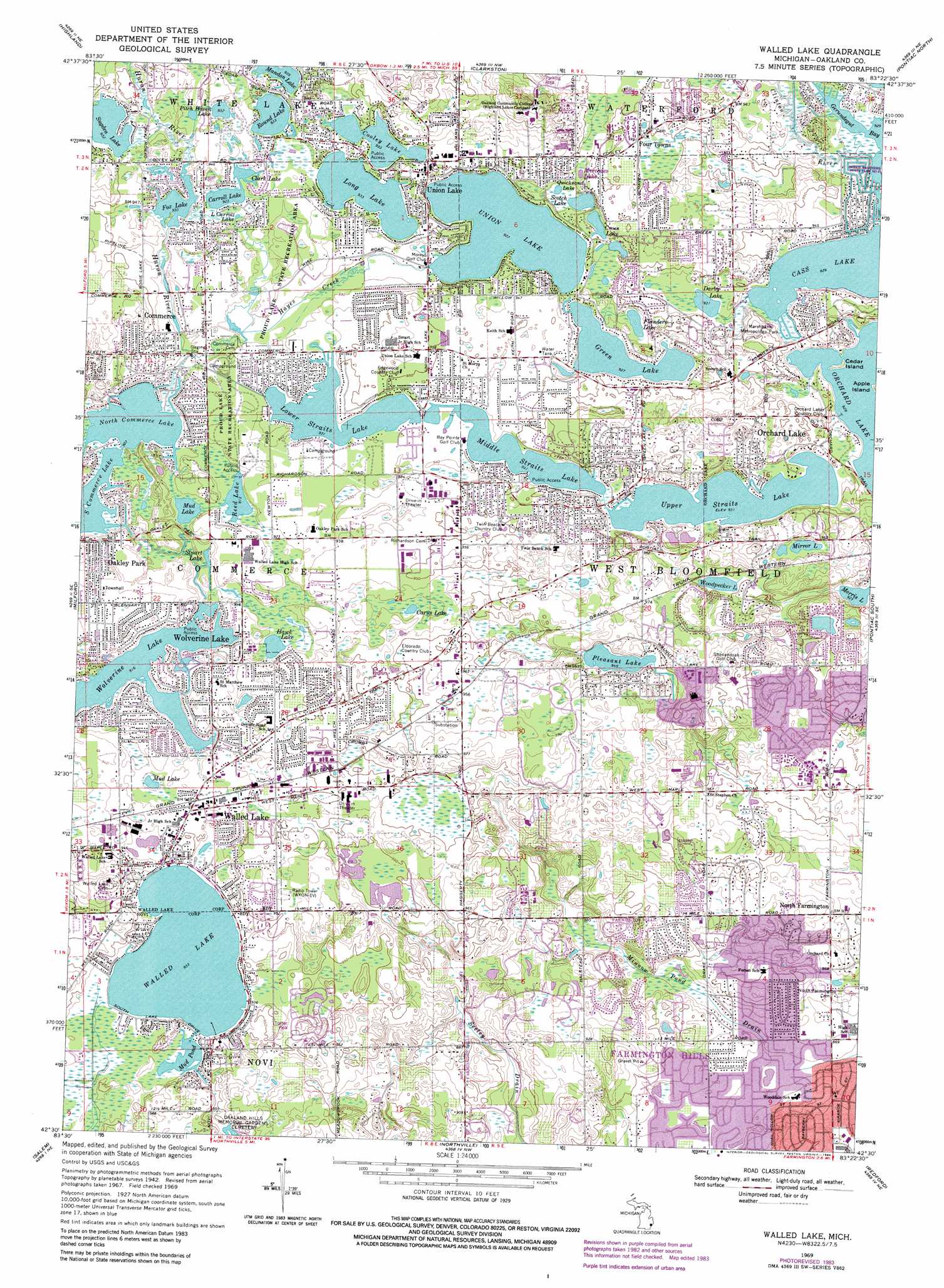
USGS Topo Quad 42083e4 - 1:24,000 scale
| Topo Map Name: | Walled Lake |
| USGS Topo Quad ID: | 42083e4 |
| Print Size: | ca. 21 1/4" wide x 27" high |
| Southeast Coordinates: | 42.5° N latitude / 83.375° W longitude |
| Map Center Coordinates: | 42.5625° N latitude / 83.4375° W longitude |
| U.S. State: | MI |
| Filename: | o42083e4.jpg |
| Download Map JPG Image: | Walled Lake topo map 1:24,000 scale |
| Map Type: | Topographic |
| Topo Series: | 7.5´ |
| Map Scale: | 1:24,000 |
| Source of Map Images: | United States Geological Survey (USGS) |
| Alternate Map Versions: |
Walled Lake MI 1945 Download PDF Buy paper map Walled Lake MI 1952, updated 1954 Download PDF Buy paper map Walled Lake MI 1952, updated 1965 Download PDF Buy paper map Walled Lake MI 1969, updated 1971 Download PDF Buy paper map Walled Lake MI 1969, updated 1974 Download PDF Buy paper map Walled Lake MI 1969, updated 1981 Download PDF Buy paper map Walled Lake MI 1969, updated 1984 Download PDF Buy paper map Walled Lake MI 1969, updated 1984 Download PDF Buy paper map Walled Lake MI 2011 Download PDF Buy paper map Walled Lake MI 2014 Download PDF Buy paper map Walled Lake MI 2017 Download PDF Buy paper map |
1:24,000 Topo Quads surrounding Walled Lake
Fenton |
Davisburg |
Ortonville |
Oxford |
Lake Orion |
West Highland |
Highland |
Clarkston |
Pontiac North |
Rochester |
Kent Lake |
Milford |
Walled Lake |
Pontiac South |
Birmingham |
South Lyon |
Salem |
Northville |
Redford |
Royal Oak |
Ann Arbor East |
Denton |
Wayne |
Inkster |
Dearborn |
> Back to 42083e1 at 1:100,000 scale
> Back to 42082a1 at 1:250,000 scale
> Back to U.S. Topo Maps home
Walled Lake topo map: Gazetteer
Walled Lake: Airports
Adams Heliport elevation 297m 974′Kamikaze Run Heliport elevation 284m 931′
McPhail Heliport elevation 295m 967′
Walled Lake: Bays
Gerundegut Bay elevation 283m 928′Walled Lake: Islands
Cedar Island elevation 283m 928′Walled Lake: Lakes
Carroll Lake elevation 281m 921′Carus Lake elevation 282m 925′
Clark Lake elevation 281m 921′
Colley Lake elevation 284m 931′
Cross Lake elevation 282m 925′
Darby Lake elevation 284m 931′
Flanders Lake elevation 281m 921′
Fox Lake elevation 283m 928′
Green Lake elevation 282m 925′
Hawk Lake elevation 280m 918′
Little Carroll Lake elevation 283m 928′
Long Lake elevation 284m 931′
Lower Straits Lake elevation 284m 931′
Mandon Lake elevation 286m 938′
Mercedes Lake elevation 285m 935′
Middle Straits Lake elevation 282m 925′
Mirror Lake elevation 289m 948′
Morris Lake elevation 281m 921′
Mud Lake elevation 283m 928′
Mud Pond elevation 284m 931′
North Commerce Lake elevation 276m 905′
Pitch Haven Lake elevation 286m 938′
Pleasant Lake elevation 287m 941′
Quicksand Lake elevation 283m 928′
Reed Lake elevation 278m 912′
Round Lake elevation 284m 931′
Scotch Lake elevation 282m 925′
South Commerce Lake elevation 276m 905′
Stuart Lake elevation 276m 905′
Sugden Lake elevation 284m 931′
Upper Straits Lake elevation 284m 931′
Walled Lake elevation 284m 931′
Wolverine Lake elevation 279m 915′
Woodbridge Lake elevation 277m 908′
Woodpecker Lake elevation 288m 944′
Walled Lake: Parks
Marshbank Metropolitan Park elevation 292m 958′Walled Lake: Populated Places
Commerce elevation 289m 948′Four Towns elevation 289m 948′
North Farmington elevation 281m 921′
Oakley Park elevation 283m 928′
Union Lake elevation 286m 938′
Walled Lake elevation 287m 941′
Westacres elevation 282m 925′
Wolverine Lake elevation 284m 931′
Walled Lake: Reservoirs
Union Lake elevation 283m 928′Walled Lake: Streams
Hayes Creek elevation 277m 908′Walled Lake digital topo map on disk
Buy this Walled Lake topo map showing relief, roads, GPS coordinates and other geographical features, as a high-resolution digital map file on DVD:
 map DVD")