Highland Topo Map Michigan
To zoom in, hover over the map of Highland
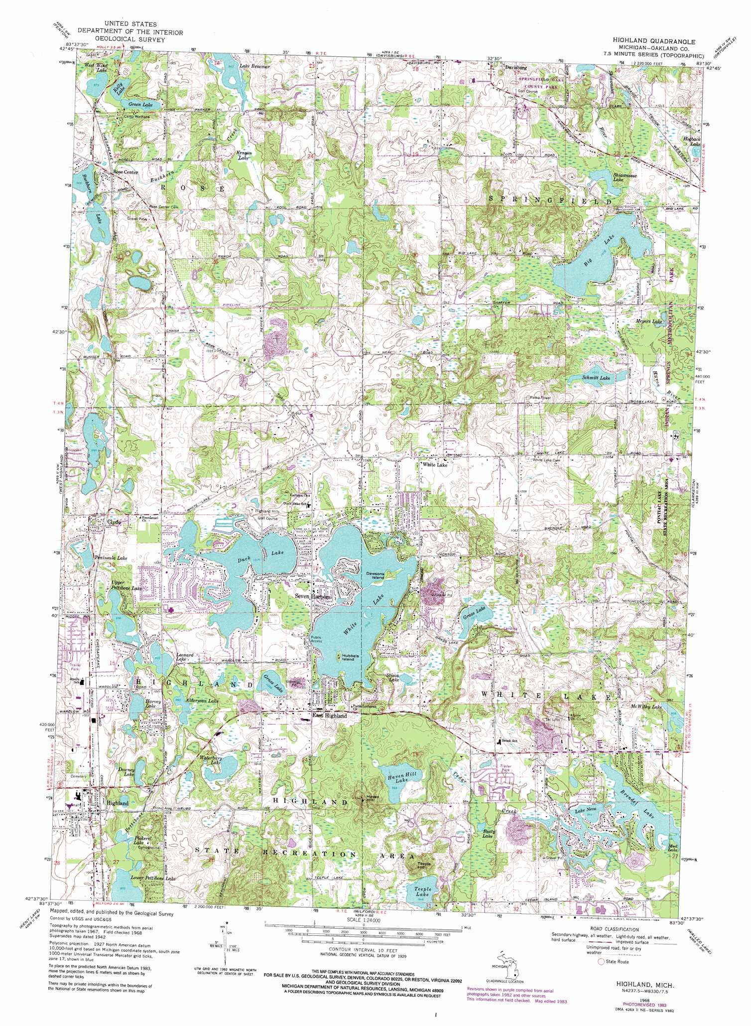
USGS Topo Quad 42083f5 - 1:24,000 scale
| Topo Map Name: | Highland |
| USGS Topo Quad ID: | 42083f5 |
| Print Size: | ca. 21 1/4" wide x 27" high |
| Southeast Coordinates: | 42.625° N latitude / 83.5° W longitude |
| Map Center Coordinates: | 42.6875° N latitude / 83.5625° W longitude |
| U.S. State: | MI |
| Filename: | o42083f5.jpg |
| Download Map JPG Image: | Highland topo map 1:24,000 scale |
| Map Type: | Topographic |
| Topo Series: | 7.5´ |
| Map Scale: | 1:24,000 |
| Source of Map Images: | United States Geological Survey (USGS) |
| Alternate Map Versions: |
Highland MI 1942, updated 1965 Download PDF Buy paper map Highland MI 1945 Download PDF Buy paper map Highland MI 1968, updated 1971 Download PDF Buy paper map Highland MI 1968, updated 1974 Download PDF Buy paper map Highland MI 1968, updated 1984 Download PDF Buy paper map Highland MI 1968, updated 1997 Download PDF Buy paper map Highland MI 2011 Download PDF Buy paper map Highland MI 2014 Download PDF Buy paper map Highland MI 2017 Download PDF Buy paper map |
1:24,000 Topo Quads surrounding Highland
Swartz Creek |
Flint South |
Goodrich |
Hadley |
Metamora |
Linden |
Fenton |
Davisburg |
Ortonville |
Oxford |
Hartland |
West Highland |
Highland |
Clarkston |
Pontiac North |
Brighton |
Kent Lake |
Milford |
Walled Lake |
Pontiac South |
Hamburg |
South Lyon |
Salem |
Northville |
Redford |
> Back to 42083e1 at 1:100,000 scale
> Back to 42082a1 at 1:250,000 scale
> Back to U.S. Topo Maps home
Highland topo map: Gazetteer
Highland: Islands
Dawsons Island elevation 315m 1033′Hubbels Island elevation 313m 1026′
Highland: Lakes
Alderman Lake elevation 303m 994′Beaty Lake elevation 288m 944′
Big Lake elevation 309m 1013′
Brendel Lake elevation 284m 931′
Buckhorn Lake elevation 295m 967′
Downey Lake elevation 301m 987′
Duck Lake elevation 310m 1017′
Grass Lake elevation 306m 1003′
Grass Lake elevation 311m 1020′
Green Lake elevation 298m 977′
Harvey Lake elevation 300m 984′
Haven Hill Lake elevation 294m 964′
Kelly Lake elevation 297m 974′
Lake Neva elevation 288m 944′
Lake O'Brien elevation 301m 987′
Leonard Lake elevation 303m 994′
Lower Pettibone Lake elevation 291m 954′
McWithy Lake elevation 292m 958′
Meyers Lake elevation 305m 1000′
Peninsula Lake elevation 314m 1030′
Pickerel Lake elevation 291m 954′
Schmitt Lake elevation 310m 1017′
Shiawassee Lake elevation 311m 1020′
Stison Lake elevation 309m 1013′
Teeple Lake elevation 288m 944′
Upper Pettibone Lake elevation 303m 994′
Waterbury Lake elevation 303m 994′
West Wind Lake elevation 298m 977′
White Lake elevation 309m 1013′
Highland: Parks
Davisburg Park elevation 306m 1003′Highland State Recreation Area elevation 302m 990′
Highland: Populated Places
Clyde elevation 314m 1030′East Highland elevation 320m 1049′
Highland elevation 308m 1010′
Seven Harbors elevation 311m 1020′
White Lake elevation 316m 1036′
Highland: Streams
Cedar Creek elevation 286m 938′Highland: Summits
Haven Hill elevation 337m 1105′Teeple Hill elevation 336m 1102′
Highland: Swamps
Kenyon Lake elevation 287m 941′Highland digital topo map on disk
Buy this Highland topo map showing relief, roads, GPS coordinates and other geographical features, as a high-resolution digital map file on DVD:
 map DVD")