West Highland Topo Map Michigan
To zoom in, hover over the map of West Highland
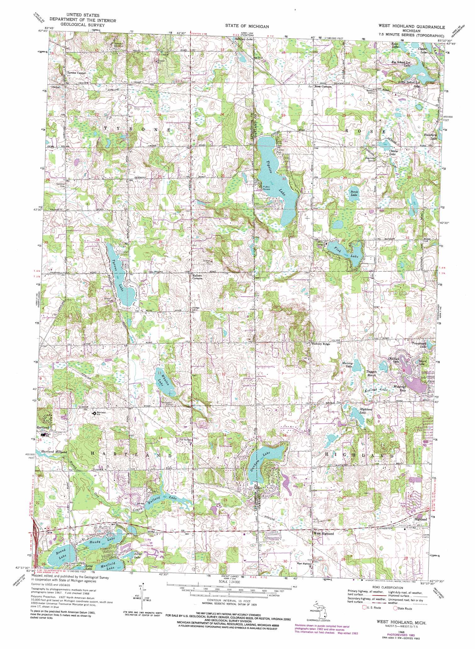
USGS Topo Quad 42083f6 - 1:24,000 scale
| Topo Map Name: | West Highland |
| USGS Topo Quad ID: | 42083f6 |
| Print Size: | ca. 21 1/4" wide x 27" high |
| Southeast Coordinates: | 42.625° N latitude / 83.625° W longitude |
| Map Center Coordinates: | 42.6875° N latitude / 83.6875° W longitude |
| U.S. State: | MI |
| Filename: | o42083f6.jpg |
| Download Map JPG Image: | West Highland topo map 1:24,000 scale |
| Map Type: | Topographic |
| Topo Series: | 7.5´ |
| Map Scale: | 1:24,000 |
| Source of Map Images: | United States Geological Survey (USGS) |
| Alternate Map Versions: |
West Highland MI 1968, updated 1971 Download PDF Buy paper map West Highland MI 1968, updated 1974 Download PDF Buy paper map West Highland MI 1968, updated 1984 Download PDF Buy paper map West Highland MI 2011 Download PDF Buy paper map West Highland MI 2014 Download PDF Buy paper map West Highland MI 2017 Download PDF Buy paper map |
1:24,000 Topo Quads surrounding West Highland
Durand |
Swartz Creek |
Flint South |
Goodrich |
Hadley |
Byron |
Linden |
Fenton |
Davisburg |
Ortonville |
Oak Grove |
Hartland |
West Highland |
Highland |
Clarkston |
Howell |
Brighton |
Kent Lake |
Milford |
Walled Lake |
Pinckney |
Hamburg |
South Lyon |
Salem |
Northville |
> Back to 42083e1 at 1:100,000 scale
> Back to 42082a1 at 1:250,000 scale
> Back to U.S. Topo Maps home
West Highland topo map: Gazetteer
West Highland: Airports
Highland Heliport elevation 317m 1040′Ponderosa Heliport elevation 310m 1017′
West Highland: Lakes
Big School Lot Lake elevation 294m 964′Charlick Lake elevation 307m 1007′
Chase Lake elevation 300m 984′
Cogger Lake elevation 294m 964′
Dunham Lake elevation 306m 1003′
Esler Lake elevation 295m 967′
Fish Lake elevation 313m 1026′
Gourd Lake elevation 307m 1007′
Handy Lake elevation 291m 954′
Hartland Millpond elevation 286m 938′
Highland Lake elevation 309m 1013′
Little School Lot Lake elevation 294m 964′
Maxfield Lake elevation 291m 954′
Murray Lake elevation 309m 1013′
Perch Lake elevation 312m 1023′
Round Lake elevation 291m 954′
Silver Lake elevation 291m 954′
Tipsico Lake elevation 309m 1013′
Tomahawk Lake elevation 306m 1003′
Tyrone Lake elevation 301m 987′
Whalen Lake elevation 297m 974′
Woodruff Lake elevation 305m 1000′
West Highland: Populated Places
Hallers Corners elevation 320m 1049′Hickory Ridge elevation 340m 1115′
Rose Corners elevation 312m 1023′
West Highland elevation 308m 1010′
West Highland: Reservoirs
Bullard Lake elevation 293m 961′West Highland: Swamps
Kellogg Lake elevation 306m 1003′Taggett Marsh elevation 306m 1003′
West Highland digital topo map on disk
Buy this West Highland topo map showing relief, roads, GPS coordinates and other geographical features, as a high-resolution digital map file on DVD:
 map DVD")