Metamora Topo Map Michigan
To zoom in, hover over the map of Metamora
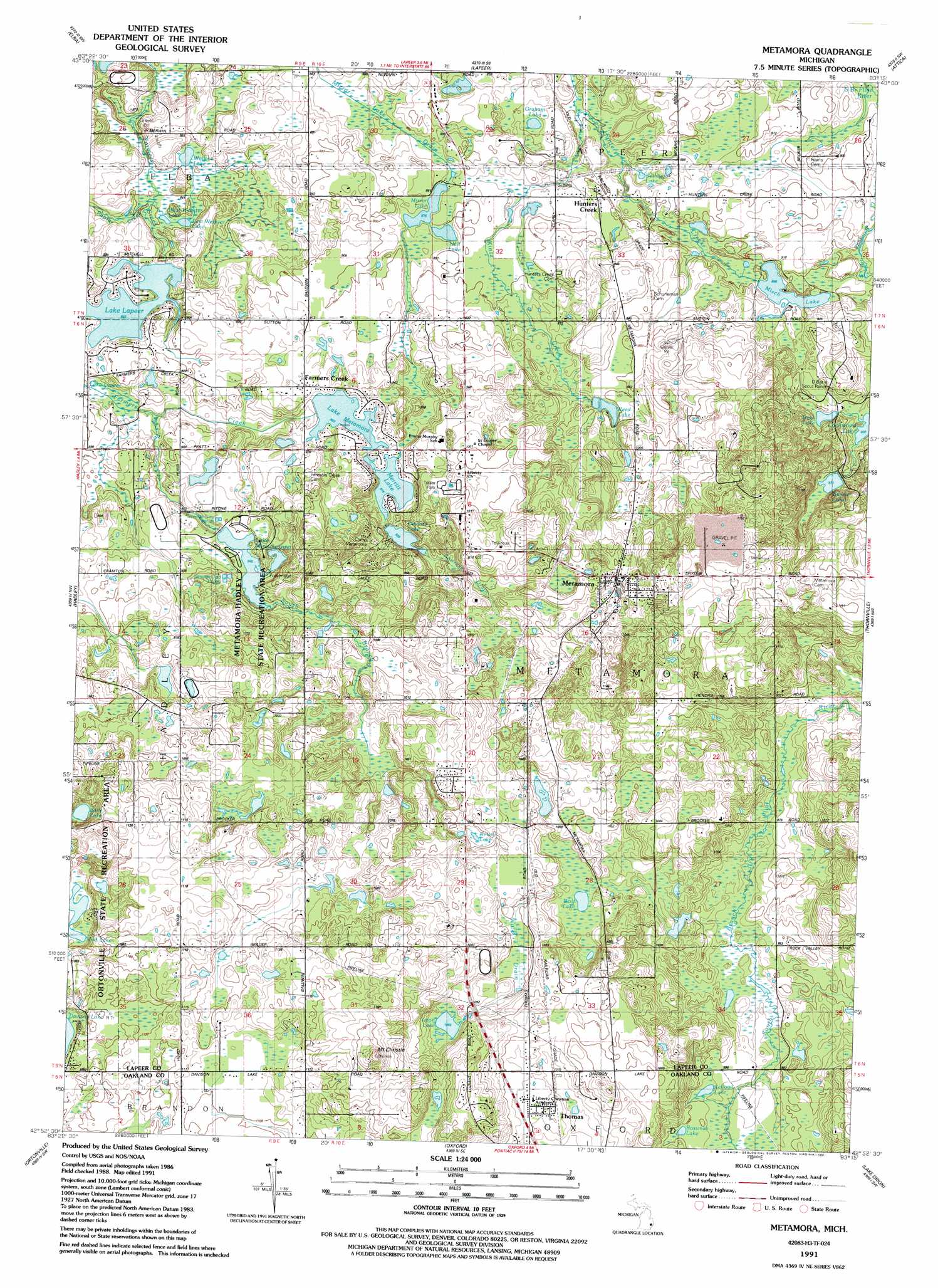
USGS Topo Quad 42083h3 - 1:24,000 scale
| Topo Map Name: | Metamora |
| USGS Topo Quad ID: | 42083h3 |
| Print Size: | ca. 21 1/4" wide x 27" high |
| Southeast Coordinates: | 42.875° N latitude / 83.25° W longitude |
| Map Center Coordinates: | 42.9375° N latitude / 83.3125° W longitude |
| U.S. State: | MI |
| Filename: | o42083h3.jpg |
| Download Map JPG Image: | Metamora topo map 1:24,000 scale |
| Map Type: | Topographic |
| Topo Series: | 7.5´ |
| Map Scale: | 1:24,000 |
| Source of Map Images: | United States Geological Survey (USGS) |
| Alternate Map Versions: |
Metamora MI 1943, updated 1964 Download PDF Buy paper map Metamora MI 1946 Download PDF Buy paper map Metamora MI 1968, updated 1970 Download PDF Buy paper map Metamora MI 1968, updated 1981 Download PDF Buy paper map Metamora MI 1991, updated 1991 Download PDF Buy paper map Metamora MI 2011 Download PDF Buy paper map Metamora MI 2014 Download PDF Buy paper map Metamora MI 2017 Download PDF Buy paper map |
1:24,000 Topo Quads surrounding Metamora
Otisville |
Columbiaville |
Barnes Lake |
North Branch |
Burnside |
Davison |
Elba |
Lapeer |
Attica |
Imlay City |
Goodrich |
Hadley |
Metamora |
Thornville |
Almont |
Davisburg |
Ortonville |
Oxford |
Lake Orion |
Romeo |
Highland |
Clarkston |
Pontiac North |
Rochester |
Utica |
> Back to 42083e1 at 1:100,000 scale
> Back to 42082a1 at 1:250,000 scale
> Back to U.S. Topo Maps home
Metamora topo map: Gazetteer
Metamora: Canals
Andress Drain elevation 309m 1013′Mirror Lake Drain elevation 266m 872′
Wolf Drain elevation 319m 1046′
Metamora: Lakes
Baily Lake elevation 314m 1030′East Webster Lake elevation 259m 849′
Graham Lake elevation 268m 879′
Hall Lake elevation 267m 875′
Kellogg Lake elevation 301m 987′
Kellogg Lake elevation 265m 869′
Kelsey Lake elevation 316m 1036′
Loon Lake elevation 324m 1062′
Merritt Lake elevation 278m 912′
Mirror Lake elevation 267m 875′
Mud Lake elevation 312m 1023′
Otsikita Lake elevation 283m 928′
Rossman Lake elevation 304m 997′
Trout Lake elevation 286m 938′
Wallace Lake elevation 259m 849′
West Webster Lake elevation 259m 849′
Wolf Lake elevation 314m 1030′
Metamora: Parks
Metamora-Hadley State Recreation Area elevation 295m 967′Metamora: Populated Places
Farmers Creek elevation 280m 918′Hunters Creek elevation 272m 892′
Ideal Villa Mobile Home Park elevation 314m 1030′
Metamora elevation 319m 1046′
Thomas elevation 330m 1082′
Metamora: Post Offices
Farmers Creek Post Office (historical) elevation 280m 918′Hunters Creek Post Office (historical) elevation 272m 892′
Metamora Post Office elevation 309m 1013′
Rural Vale Post Office (historical) elevation 335m 1099′
Metamora: Reservoirs
Beaver Lake elevation 296m 971′Lake Lapeer elevation 264m 866′
Lake Metamora elevation 275m 902′
Lake Minnawanna elevation 288m 944′
Misch Lake elevation 273m 895′
Reed Lake elevation 286m 938′
Metamora: Streams
Kintz Creek elevation 259m 849′Poplar Creek elevation 259m 849′
South Branch Farmers Creek elevation 265m 869′
Metamora: Summits
Mount Christie elevation 389m 1276′Metamora digital topo map on disk
Buy this Metamora topo map showing relief, roads, GPS coordinates and other geographical features, as a high-resolution digital map file on DVD:
 map DVD")