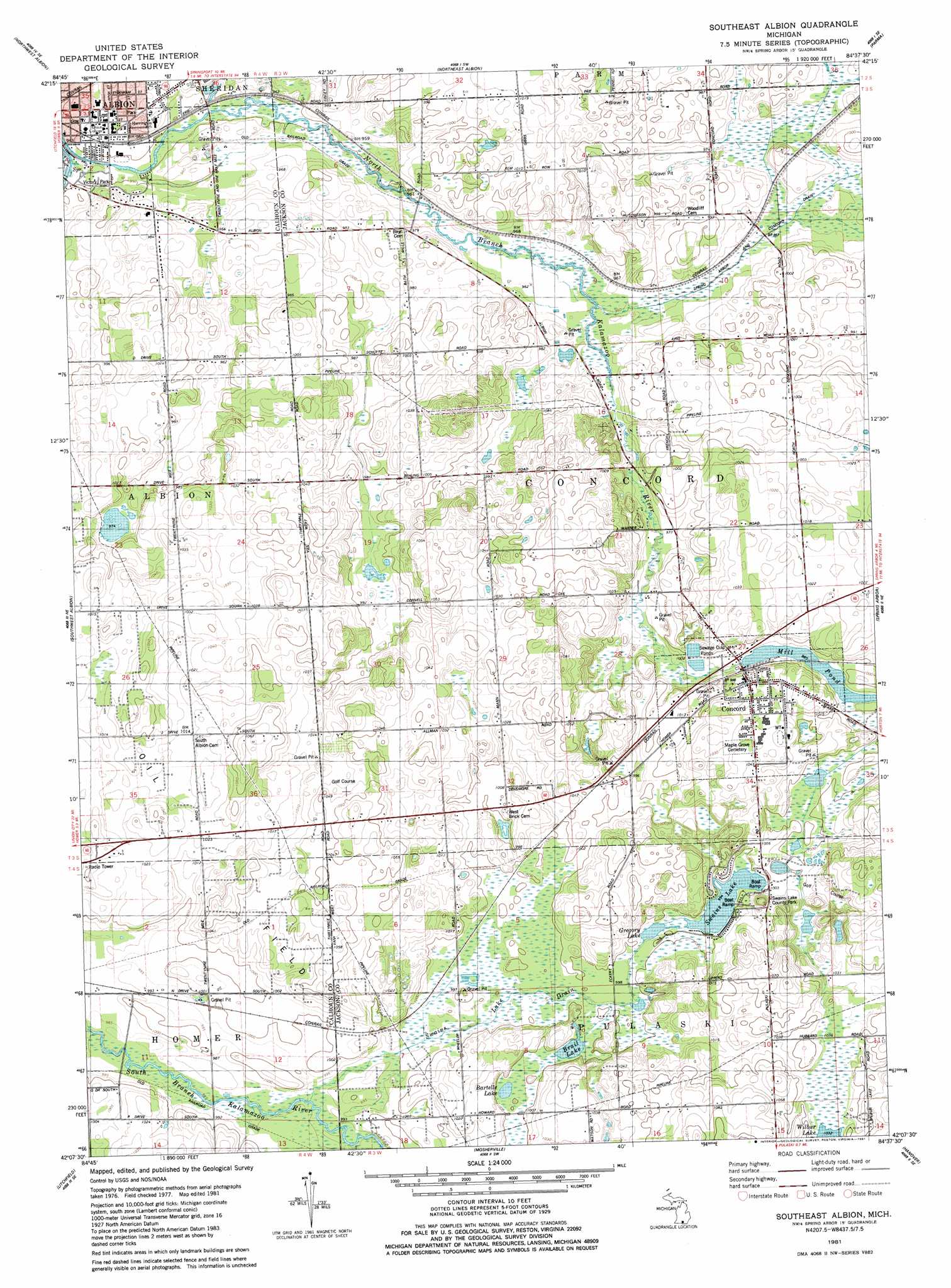
Southeast Albion Topo Map Michigan
To zoom in, hover over the map of Southeast Albion
USGS Topo Quad 42084b6 - 1:24,000 scale
| Topo Map Name: | Southeast Albion |
| USGS Topo Quad ID: | 42084b6 |
| Print Size: | ca. 21 1/4" wide x 27" high |
| Southeast Coordinates: | 42.125° N latitude / 84.625° W longitude |
| Map Center Coordinates: | 42.1875° N latitude / 84.6875° W longitude |
| U.S. State: | MI |
| Filename: | o42084b6.jpg |
| Download Map JPG Image: | Southeast Albion topo map 1:24,000 scale |
| Map Type: | Topographic |
| Topo Series: | 7.5´ |
| Map Scale: | 1:24,000 |
| Source of Map Images: | United States Geological Survey (USGS) |
| Alternate Map Versions: |
Southeast Albion MI 1981, updated 1981 Download PDF Buy paper map Southeast Albion MI 2011 Download PDF Buy paper map Southeast Albion MI 2014 Download PDF Buy paper map Southeast Albion MI 2017 Download PDF Buy paper map |
1:24,000 Topo Quads surrounding Southeast Albion
Olivet |
Duck Lake |
Springport |
Onondaga |
Leslie |
Marshall |
Northwest Albion |
Northeast Albion |
Parma |
Jackson North |
Lyon Lake |
Southwest Albion |
Southeast Albion |
Spring Arbor |
Jackson South |
Tekonsha |
Litchfield |
Mosherville |
Hanover |
Somerset Center |
Coldwater East |
Allen |
Hillsdale |
North Adams |
Wheatland |
> Back to 42084a1 at 1:100,000 scale
> Back to 42084a1 at 1:250,000 scale
> Back to U.S. Topo Maps home
Southeast Albion topo map: Gazetteer
Southeast Albion: Canals
Spring Arbor and Concord Drain elevation 296m 971′Swains Lake Drain elevation 302m 990′
Southeast Albion: Lakes
Bartelle Lake elevation 305m 1000′Brail Lake elevation 303m 994′
Gregory Lake elevation 304m 997′
Swains Lake elevation 304m 997′
Southeast Albion: Parks
Swains Lake County Park elevation 323m 1059′Victory Park elevation 288m 944′
Southeast Albion: Populated Places
Concord elevation 312m 1023′Southeast Albion: Streams
North Branch Kalamazoo River elevation 287m 941′South Branch Kalamazoo River elevation 287m 941′
Southeast Albion digital topo map on disk
Buy this Southeast Albion topo map showing relief, roads, GPS coordinates and other geographical features, as a high-resolution digital map file on DVD:
Northern Illinois, Northern Indiana & Southwestern Michigan
Buy digital topo maps: Northern Illinois, Northern Indiana & Southwestern Michigan