Jackson North Topo Map Michigan
To zoom in, hover over the map of Jackson North
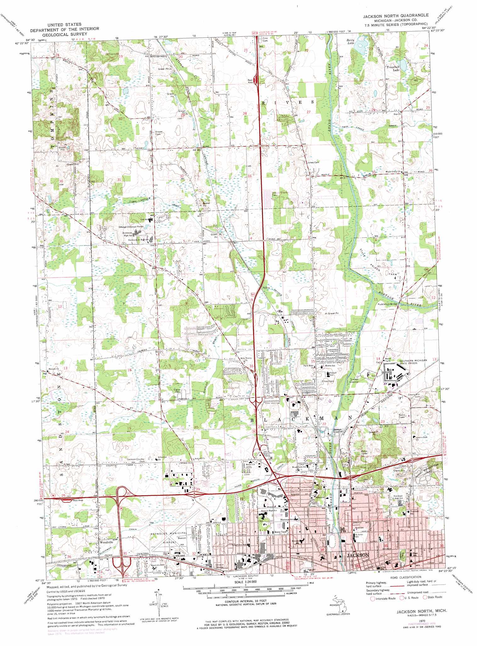
USGS Topo Quad 42084c4 - 1:24,000 scale
| Topo Map Name: | Jackson North |
| USGS Topo Quad ID: | 42084c4 |
| Print Size: | ca. 21 1/4" wide x 27" high |
| Southeast Coordinates: | 42.25° N latitude / 84.375° W longitude |
| Map Center Coordinates: | 42.3125° N latitude / 84.4375° W longitude |
| U.S. State: | MI |
| Filename: | o42084c4.jpg |
| Download Map JPG Image: | Jackson North topo map 1:24,000 scale |
| Map Type: | Topographic |
| Topo Series: | 7.5´ |
| Map Scale: | 1:24,000 |
| Source of Map Images: | United States Geological Survey (USGS) |
| Alternate Map Versions: |
Jackson North MI 1970, updated 1973 Download PDF Buy paper map Jackson North MI 1970, updated 1978 Download PDF Buy paper map Jackson North MI 2011 Download PDF Buy paper map Jackson North MI 2014 Download PDF Buy paper map Jackson North MI 2017 Download PDF Buy paper map |
1:24,000 Topo Quads surrounding Jackson North
Eaton Rapids |
Aurelius |
Mason |
Dansville |
Millville |
Springport |
Onondaga |
Leslie |
Pleasant Lake |
Stockbridge |
Northeast Albion |
Parma |
Jackson North |
Gilletts Lake |
Grass Lake |
Southeast Albion |
Spring Arbor |
Jackson South |
Michigan Center |
Norvell |
Mosherville |
Hanover |
Somerset Center |
Cement City |
Onsted |
> Back to 42084a1 at 1:100,000 scale
> Back to 42084a1 at 1:250,000 scale
> Back to U.S. Topo Maps home
Jackson North topo map: Gazetteer
Jackson North: Airports
Jackson County Airport-Reynolds Field elevation 303m 994′W A Foote Memorial Hospital Heliport elevation 296m 971′
Jackson North: Bridges
Puddleford Bridge elevation 277m 908′Jackson North: Canals
Hurd Marvin Drain elevation 291m 954′Sandstone Blackman Drain elevation 291m 954′
Tobin Snyder Drain elevation 291m 954′
Wheeler Drain elevation 294m 964′
Jackson North: Lakes
Berry Lake elevation 275m 902′Trumbull Lake elevation 284m 931′
Jackson North: Parks
Loomis Park elevation 301m 987′Jackson North: Populated Places
Woodville elevation 299m 980′Jackson North: Streams
Portage River elevation 277m 908′Jackson North digital topo map on disk
Buy this Jackson North topo map showing relief, roads, GPS coordinates and other geographical features, as a high-resolution digital map file on DVD:
Northern Illinois, Northern Indiana & Southwestern Michigan
Buy digital topo maps: Northern Illinois, Northern Indiana & Southwestern Michigan