Dansville Topo Map Michigan
To zoom in, hover over the map of Dansville
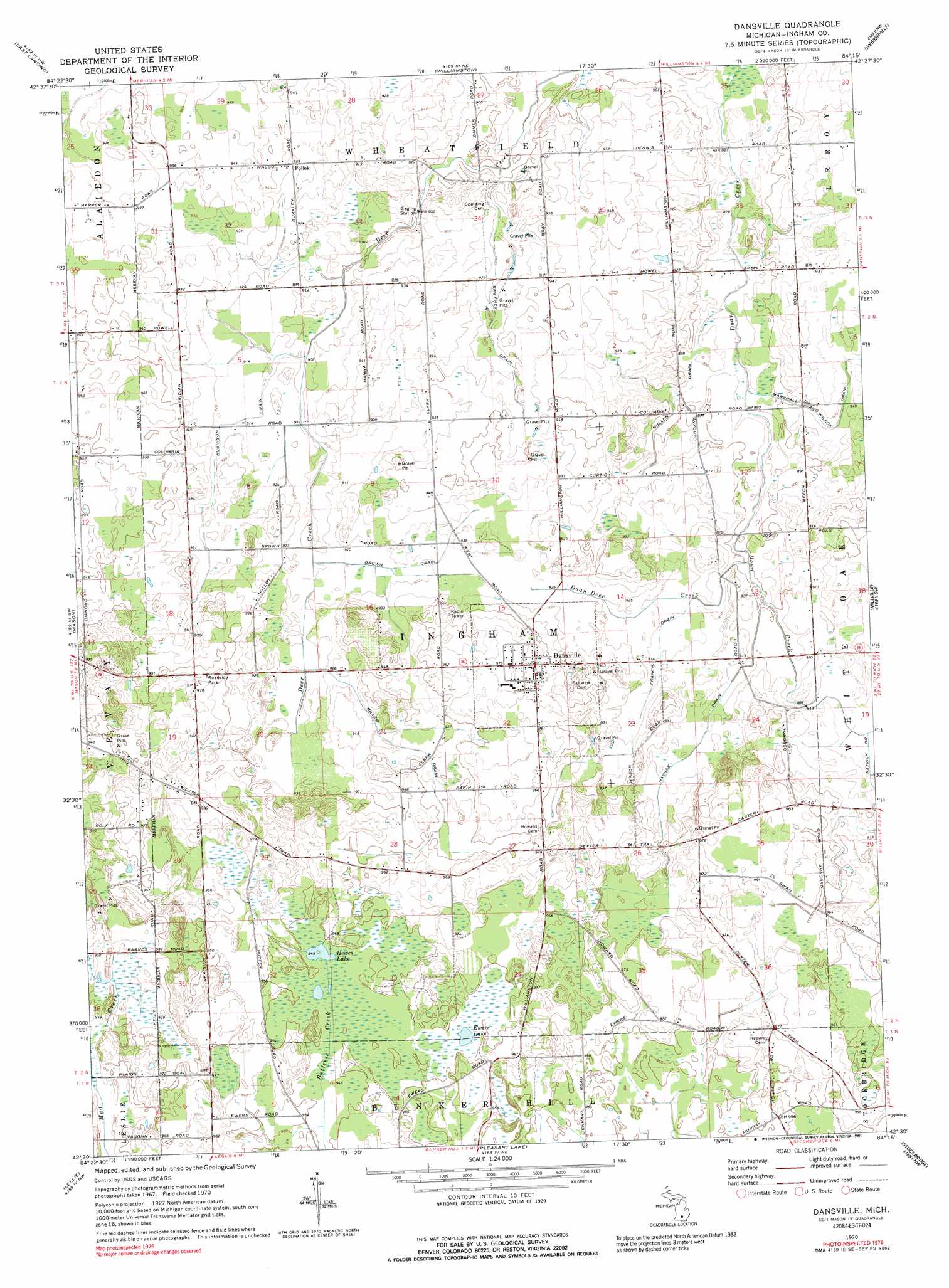
USGS Topo Quad 42084e3 - 1:24,000 scale
| Topo Map Name: | Dansville |
| USGS Topo Quad ID: | 42084e3 |
| Print Size: | ca. 21 1/4" wide x 27" high |
| Southeast Coordinates: | 42.5° N latitude / 84.25° W longitude |
| Map Center Coordinates: | 42.5625° N latitude / 84.3125° W longitude |
| U.S. State: | MI |
| Filename: | o42084e3.jpg |
| Download Map JPG Image: | Dansville topo map 1:24,000 scale |
| Map Type: | Topographic |
| Topo Series: | 7.5´ |
| Map Scale: | 1:24,000 |
| Source of Map Images: | United States Geological Survey (USGS) |
| Alternate Map Versions: |
Dansville MI 1970, updated 1989 Download PDF Buy paper map Dansville MI 1970, updated 1989 Download PDF Buy paper map Dansville MI 1970, updated 1991 Download PDF Buy paper map Dansville MI 2011 Download PDF Buy paper map Dansville MI 2014 Download PDF Buy paper map Dansville MI 2017 Download PDF Buy paper map |
1:24,000 Topo Quads surrounding Dansville
Lansing North |
Bath |
Shaftsburg |
Perry |
Corunna Se |
Lansing South |
East Lansing |
Williamston |
Webberville |
Fowlerville |
Aurelius |
Mason |
Dansville |
Millville |
Parkers Corners |
Onondaga |
Leslie |
Pleasant Lake |
Stockbridge |
Gregory |
Parma |
Jackson North |
Gilletts Lake |
Grass Lake |
Chelsea |
> Back to 42084e1 at 1:100,000 scale
> Back to 42084a1 at 1:250,000 scale
> Back to U.S. Topo Maps home
Dansville topo map: Gazetteer
Dansville: Canals
Brown Drain elevation 280m 918′Francis Drain elevation 277m 908′
Hayhoe Drain elevation 277m 908′
Marshall and Wilcox Drain elevation 277m 908′
Miller Drain elevation 284m 931′
Mullen Drain elevation 271m 889′
Robinson Drain elevation 277m 908′
Sweeney Drain elevation 282m 925′
Dansville: Lakes
Ewers Lake elevation 289m 948′Hewes Lake elevation 288m 944′
Dansville: Populated Places
Dansville elevation 294m 964′Pollok elevation 283m 928′
Dansville: Streams
Doan Deer Creek elevation 272m 892′Dansville digital topo map on disk
Buy this Dansville topo map showing relief, roads, GPS coordinates and other geographical features, as a high-resolution digital map file on DVD:
Northern Illinois, Northern Indiana & Southwestern Michigan
Buy digital topo maps: Northern Illinois, Northern Indiana & Southwestern Michigan