Portland South Topo Map Michigan
To zoom in, hover over the map of Portland South
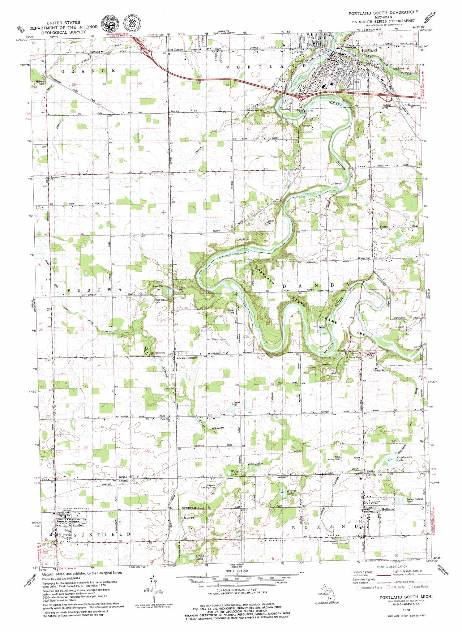
USGS Topo Quad 42084g8 - 1:24,000 scale
| Topo Map Name: | Portland South |
| USGS Topo Quad ID: | 42084g8 |
| Print Size: | ca. 21 1/4" wide x 27" high |
| Southeast Coordinates: | 42.75° N latitude / 84.875° W longitude |
| Map Center Coordinates: | 42.8125° N latitude / 84.9375° W longitude |
| U.S. State: | MI |
| Filename: | o42084g8.jpg |
| Download Map JPG Image: | Portland South topo map 1:24,000 scale |
| Map Type: | Topographic |
| Topo Series: | 7.5´ |
| Map Scale: | 1:24,000 |
| Source of Map Images: | United States Geological Survey (USGS) |
| Alternate Map Versions: |
Portland South MI 1978, updated 1979 Download PDF Buy paper map Portland South MI 2011 Download PDF Buy paper map Portland South MI 2014 Download PDF Buy paper map Portland South MI 2017 Download PDF Buy paper map |
1:24,000 Topo Quads surrounding Portland South
Belding |
Shiloh |
Palo |
Hubbardston |
Maple Rapids |
Saranac |
Ionia |
Portland North |
Wasphalia |
Riley |
Lake Odessa |
Woodbury |
Portland South |
Eagle |
Wacousta |
Woodland |
Saubee Lake |
Hoytville |
Needmore |
Dimondale |
Maple Grove |
Nashville |
Chester |
Charlotte |
Eaton Rapids |
> Back to 42084e1 at 1:100,000 scale
> Back to 42084a1 at 1:250,000 scale
> Back to U.S. Topo Maps home
Portland South topo map: Gazetteer
Portland South: Airports
Airbatco Field elevation 254m 833′Portland South: Canals
Cryderman Lake Drain elevation 249m 816′Gardner Hiar Drain elevation 247m 810′
Gunn and Ramsey Drain elevation 250m 820′
Parker Extension elevation 260m 853′
Stiffler Drain elevation 242m 793′
Portland South: Crossings
Interchange 71 elevation 237m 777′Interchange 73 elevation 244m 800′
Interchange 76 elevation 231m 757′
Portland South: Lakes
Cryderman Lake elevation 249m 816′Gregg Lake elevation 250m 820′
Hoover Lake elevation 257m 843′
Twin Lakes elevation 248m 813′
Wyman Lake elevation 248m 813′
Portland South: Parks
Alton Park elevation 235m 770′Brush Street Park elevation 237m 777′
Grand Army of the Republic Hall Historical Marker elevation 263m 862′
Portland State Game Area elevation 228m 748′
Powers Park elevation 217m 711′
Thompson Field elevation 216m 708′
William Toan Park elevation 218m 715′
Portland South: Populated Places
Mulliken elevation 263m 862′Parkview Estates Mobile Home Park elevation 247m 810′
Portland elevation 221m 725′
Sebewa Corners elevation 251m 823′
Sunfield elevation 263m 862′
Sunset Ridge Mobile Home Park elevation 247m 810′
Sunset View Mobile Home Park elevation 238m 780′
Portland South: Post Offices
Danby Post Office (historical) elevation 250m 820′Jeffrey Post Office (historical) elevation 245m 803′
Mulliken Post Office elevation 264m 866′
Portland Post Office elevation 219m 718′
Sebewa Post Office (historical) elevation 251m 823′
Sunfield Post Office elevation 264m 866′
Portland South: Streams
Looking Glass River elevation 216m 708′Sebewa Creek elevation 223m 731′
Portland South digital topo map on disk
Buy this Portland South topo map showing relief, roads, GPS coordinates and other geographical features, as a high-resolution digital map file on DVD:
Northern Illinois, Northern Indiana & Southwestern Michigan
Buy digital topo maps: Northern Illinois, Northern Indiana & Southwestern Michigan