Corunna Topo Map Michigan
To zoom in, hover over the map of Corunna
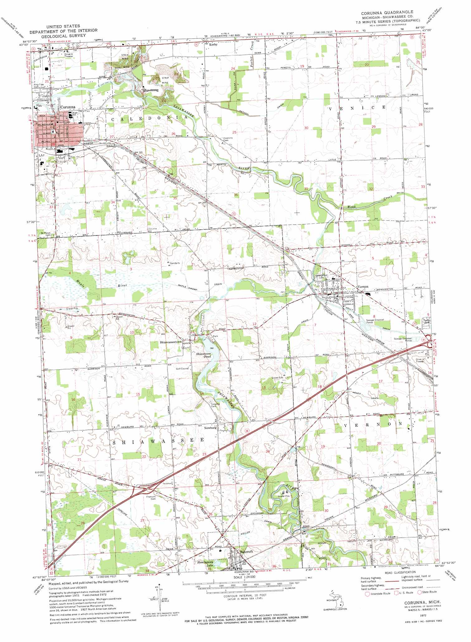
USGS Topo Quad 42084h1 - 1:24,000 scale
| Topo Map Name: | Corunna |
| USGS Topo Quad ID: | 42084h1 |
| Print Size: | ca. 21 1/4" wide x 27" high |
| Southeast Coordinates: | 42.875° N latitude / 84° W longitude |
| Map Center Coordinates: | 42.9375° N latitude / 84.0625° W longitude |
| U.S. State: | MI |
| Filename: | o42084h1.jpg |
| Download Map JPG Image: | Corunna topo map 1:24,000 scale |
| Map Type: | Topographic |
| Topo Series: | 7.5´ |
| Map Scale: | 1:24,000 |
| Source of Map Images: | United States Geological Survey (USGS) |
| Alternate Map Versions: |
Corunna MI 1972, updated 1975 Download PDF Buy paper map Corunna MI 2011 Download PDF Buy paper map Corunna MI 2014 Download PDF Buy paper map Corunna MI 2017 Download PDF Buy paper map |
1:24,000 Topo Quads surrounding Corunna
Chapin |
Chesaning West |
Chesaning East |
Montrose |
Birch Run South |
Ovid East |
Owosso North |
Easton |
New Lothrop |
Flushing |
Laingsburg |
Owosso South |
Corunna |
Durand |
Swartz Creek |
Shaftsburg |
Perry |
Corunna Se |
Byron |
Linden |
Williamston |
Webberville |
Fowlerville |
Oak Grove |
Hartland |
> Back to 42084e1 at 1:100,000 scale
> Back to 42084a1 at 1:250,000 scale
> Back to U.S. Topo Maps home
Corunna topo map: Gazetteer
Corunna: Canals
Caledonia Drain elevation 226m 741′Gilna Drain elevation 229m 751′
Hathon Drain elevation 229m 751′
Holly Drain elevation 232m 761′
Hovey Drain elevation 243m 797′
Keller Drain elevation 249m 816′
Maple Swamp Drain elevation 235m 770′
Pratt Drain elevation 231m 757′
Corunna: Crossings
Interchange 113 elevation 259m 849′Interchange 118 elevation 238m 780′
Corunna: Lakes
Hemingway Lake elevation 255m 836′Corunna: Parks
Corunna Public Schools Historical Marker elevation 229m 751′Davis Park elevation 245m 803′
First National Bank Historical Marker elevation 228m 748′
Geeck Road Park elevation 254m 833′
Governor Andrew Parsons Historical Marker elevation 232m 761′
Heritage Park elevation 223m 731′
John Goebel Memorial Park elevation 230m 754′
Michigan's First Coal Mine Historical Marker elevation 227m 744′
Shiatown Park elevation 247m 810′
Shiawassee County Courthouse Historical Marker elevation 228m 748′
Shiawassee Street School Historical Marker elevation 229m 751′
Corunna: Populated Places
Bancroft elevation 261m 856′Corunna elevation 227m 744′
Country Manor Mobile Home Park elevation 246m 807′
Kerby elevation 234m 767′
Lakeview Estates Mobile Home Park elevation 234m 767′
Newburg elevation 256m 839′
Shiawasseetown elevation 252m 826′
Vernon elevation 238m 780′
Corunna: Post Offices
Bancroft Post Office elevation 261m 856′Corunna Post Office elevation 226m 741′
Fremont Post Office (historical) elevation 259m 849′
Kerby Post Office (historical) elevation 234m 767′
North Newburg Post Office (historical) elevation 255m 836′
Vernon Post Office elevation 238m 780′
Corunna: Reservoirs
Shiawassee Pond elevation 238m 780′Corunna: Streams
Webb Creek elevation 228m 748′Corunna digital topo map on disk
Buy this Corunna topo map showing relief, roads, GPS coordinates and other geographical features, as a high-resolution digital map file on DVD:
Northern Illinois, Northern Indiana & Southwestern Michigan
Buy digital topo maps: Northern Illinois, Northern Indiana & Southwestern Michigan