Schoolcraft Topo Map Michigan
To zoom in, hover over the map of Schoolcraft
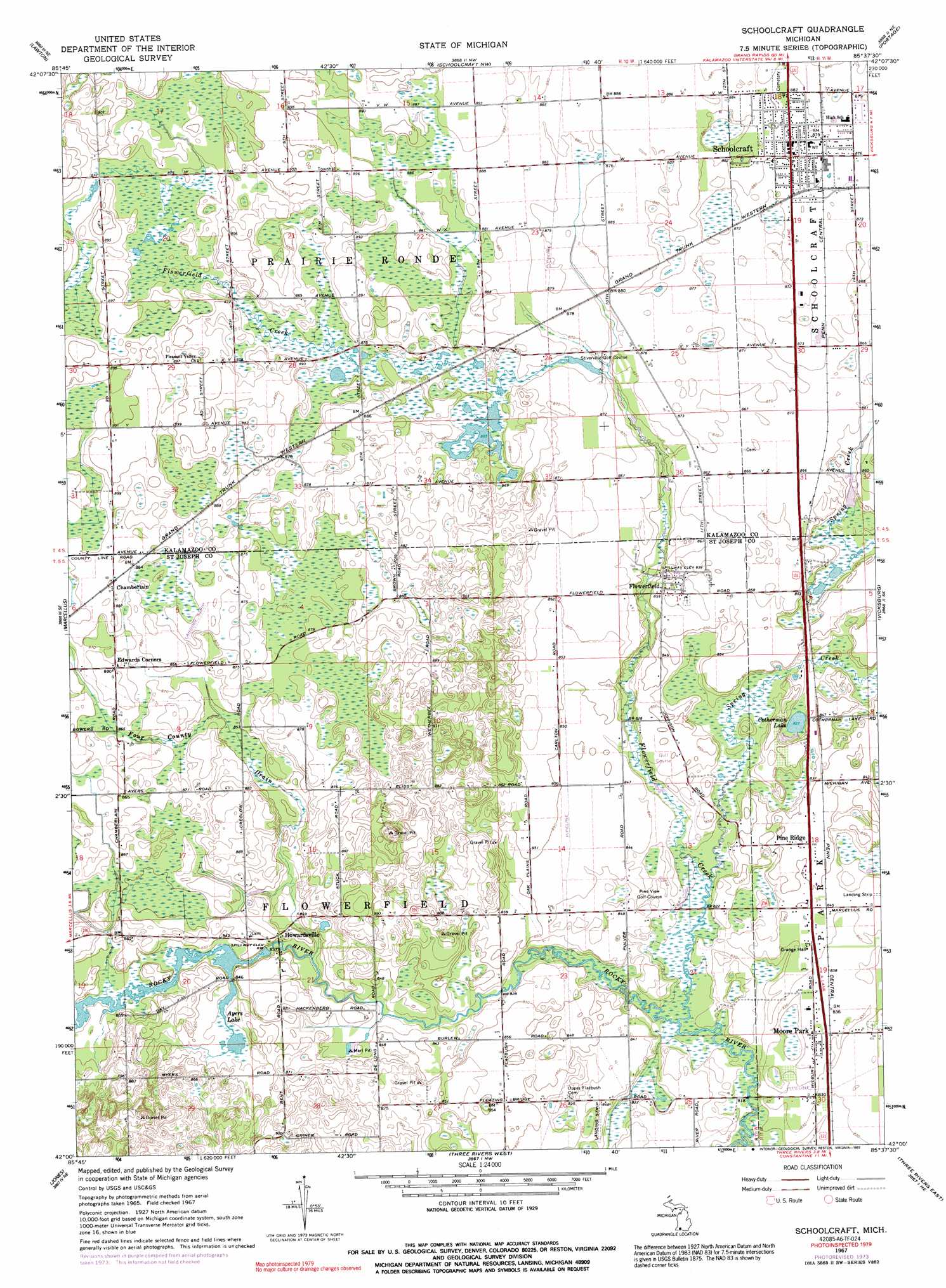
USGS Topo Quad 42085a6 - 1:24,000 scale
| Topo Map Name: | Schoolcraft |
| USGS Topo Quad ID: | 42085a6 |
| Print Size: | ca. 21 1/4" wide x 27" high |
| Southeast Coordinates: | 42° N latitude / 85.625° W longitude |
| Map Center Coordinates: | 42.0625° N latitude / 85.6875° W longitude |
| U.S. State: | MI |
| Filename: | o42085a6.jpg |
| Download Map JPG Image: | Schoolcraft topo map 1:24,000 scale |
| Map Type: | Topographic |
| Topo Series: | 7.5´ |
| Map Scale: | 1:24,000 |
| Source of Map Images: | United States Geological Survey (USGS) |
| Alternate Map Versions: |
Schoolcraft MI 1967, updated 1969 Download PDF Buy paper map Schoolcraft MI 1967, updated 1974 Download PDF Buy paper map Schoolcraft MI 1967, updated 1992 Download PDF Buy paper map Schoolcraft MI 2011 Download PDF Buy paper map Schoolcraft MI 2014 Download PDF Buy paper map Schoolcraft MI 2016 Download PDF Buy paper map |
1:24,000 Topo Quads surrounding Schoolcraft
Gobles West |
Gobles East |
Kalamazoo Sw |
Kalamazoo |
Galesburg |
Paw Paw |
Lawton |
Schoolcraft Nw |
Portage |
Adams Park |
Decatur |
Marcellus |
Schoolcraft |
Vicksburg |
Mendon |
Vandalia |
Jones |
Three Rivers West |
Three Rivers East |
Nottawa |
Adamsville |
Mottville |
Constantine |
Klinger Lake |
Sturgis |
> Back to 42085a1 at 1:100,000 scale
> Back to 42084a1 at 1:250,000 scale
> Back to U.S. Topo Maps home
Schoolcraft topo map: Gazetteer
Schoolcraft: Basins
Marl Pit elevation 256m 839′Schoolcraft: Lakes
Ayers Lake elevation 254m 833′Cotherman Lake elevation 252m 826′
Schoolcraft: Populated Places
Chamberlain elevation 271m 889′Flowerfield elevation 259m 849′
Howardsville elevation 261m 856′
Moore Park elevation 253m 830′
Pine Ridge elevation 259m 849′
Schoolcraft elevation 268m 879′
Schoolcraft: Post Offices
Flowerfield Post Office (historical) elevation 259m 849′Howardsville Post Office (historical) elevation 261m 856′
Leesburg Post Office (historical) elevation 270m 885′
Moorepark Post Office (historical) elevation 253m 830′
Schoolcraft: Streams
Flowerfield Creek elevation 250m 820′Four County Drain elevation 253m 830′
Spring Creek elevation 250m 820′
Schoolcraft digital topo map on disk
Buy this Schoolcraft topo map showing relief, roads, GPS coordinates and other geographical features, as a high-resolution digital map file on DVD:
Northern Illinois, Northern Indiana & Southwestern Michigan
Buy digital topo maps: Northern Illinois, Northern Indiana & Southwestern Michigan