Portage Topo Map Michigan
To zoom in, hover over the map of Portage
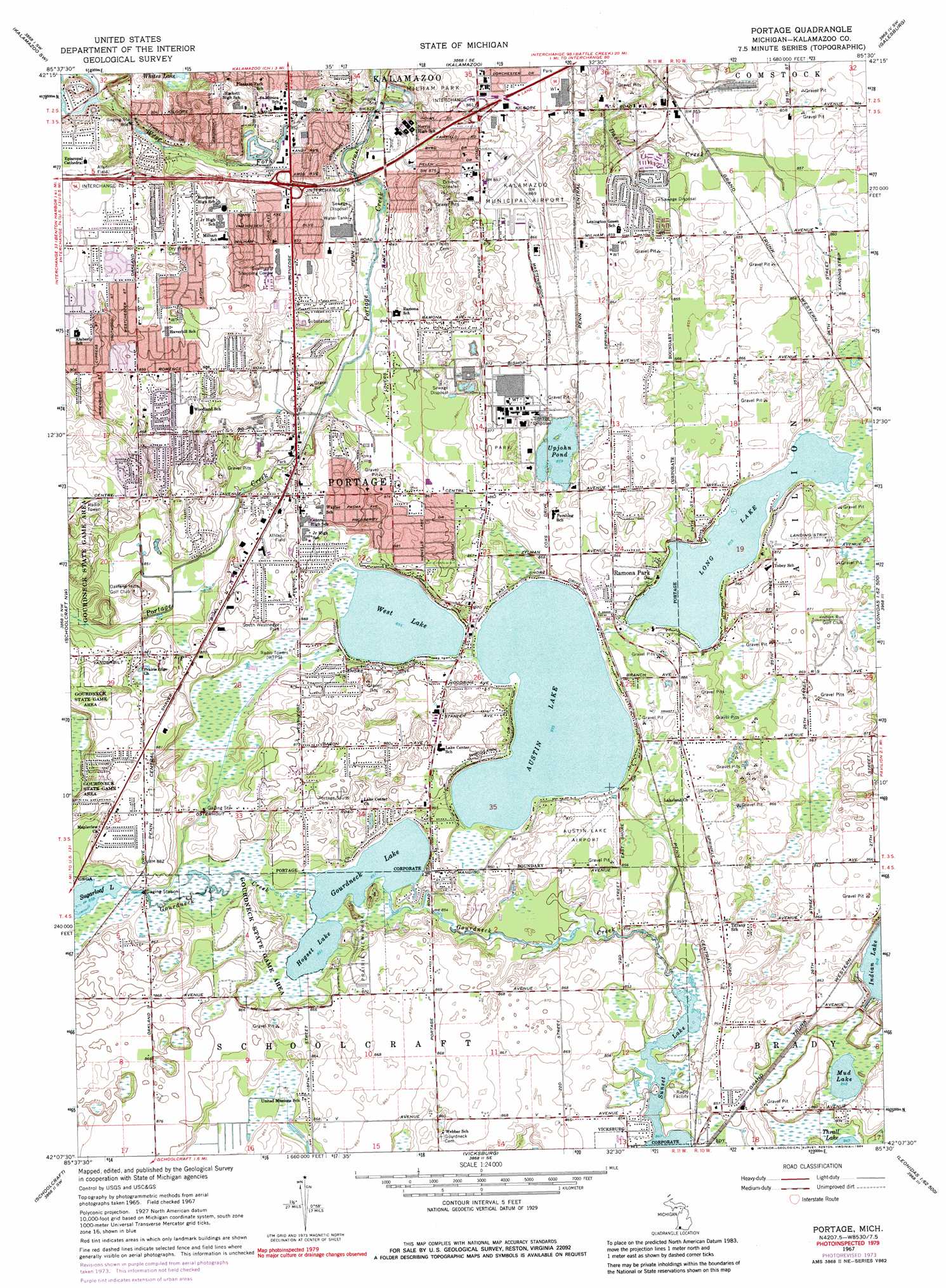
USGS Topo Quad 42085b5 - 1:24,000 scale
| Topo Map Name: | Portage |
| USGS Topo Quad ID: | 42085b5 |
| Print Size: | ca. 21 1/4" wide x 27" high |
| Southeast Coordinates: | 42.125° N latitude / 85.5° W longitude |
| Map Center Coordinates: | 42.1875° N latitude / 85.5625° W longitude |
| U.S. State: | MI |
| Filename: | o42085b5.jpg |
| Download Map JPG Image: | Portage topo map 1:24,000 scale |
| Map Type: | Topographic |
| Topo Series: | 7.5´ |
| Map Scale: | 1:24,000 |
| Source of Map Images: | United States Geological Survey (USGS) |
| Alternate Map Versions: |
Portage MI 1967, updated 1969 Download PDF Buy paper map Portage MI 1967, updated 1974 Download PDF Buy paper map Portage MI 1967, updated 1984 Download PDF Buy paper map Portage MI 2011 Download PDF Buy paper map Portage MI 2014 Download PDF Buy paper map Portage MI 2016 Download PDF Buy paper map |
1:24,000 Topo Quads surrounding Portage
Merson |
Otsego |
Kalamazoo Ne |
Delton |
Banfield |
Gobles East |
Kalamazoo Sw |
Kalamazoo |
Galesburg |
Augusta |
Lawton |
Schoolcraft Nw |
Portage |
Adams Park |
Climax |
Marcellus |
Schoolcraft |
Vicksburg |
Mendon |
Leonidas |
Jones |
Three Rivers West |
Three Rivers East |
Nottawa |
Colon |
> Back to 42085a1 at 1:100,000 scale
> Back to 42084a1 at 1:250,000 scale
> Back to U.S. Topo Maps home
Portage topo map: Gazetteer
Portage: Airports
Austin Lake Airport elevation 262m 859′Kalamazoo-Battle Creek International Airport elevation 264m 866′
Portage: Crossings
Interchange 75 elevation 276m 905′Interchange 76 elevation 263m 862′
Interchange 78 elevation 267m 875′
Portage: Lakes
Austin Lake elevation 260m 853′Gourdneck Lake elevation 259m 849′
Hogset Lake elevation 259m 849′
Long Lake elevation 260m 853′
Mud Lake elevation 258m 846′
Sunset Lake elevation 258m 846′
Upjohn Pond elevation 262m 859′
West Lake elevation 260m 853′
Portage: Parks
Allen Field elevation 277m 908′Indian Fields Historical Marker elevation 265m 869′
Milham Park elevation 260m 853′
Prairieview Park elevation 262m 859′
South Westnedge Park elevation 262m 859′
Portage: Populated Places
Portage elevation 268m 879′Ramona Park elevation 264m 866′
Portage: Post Offices
Austin's Lake Post Office (historical) elevation 264m 866′Portage: Streams
Gourdneck Creek elevation 258m 846′West Fork Portage Creek elevation 249m 816′
Portage digital topo map on disk
Buy this Portage topo map showing relief, roads, GPS coordinates and other geographical features, as a high-resolution digital map file on DVD:
Northern Illinois, Northern Indiana & Southwestern Michigan
Buy digital topo maps: Northern Illinois, Northern Indiana & Southwestern Michigan