Banfield Topo Map Michigan
To zoom in, hover over the map of Banfield
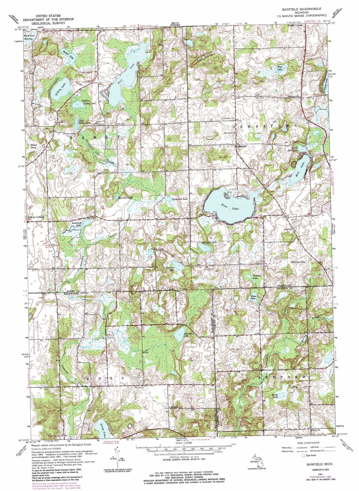
USGS Topo Quad 42085d3 - 1:24,000 scale
| Topo Map Name: | Banfield |
| USGS Topo Quad ID: | 42085d3 |
| Print Size: | ca. 21 1/4" wide x 27" high |
| Southeast Coordinates: | 42.375° N latitude / 85.25° W longitude |
| Map Center Coordinates: | 42.4375° N latitude / 85.3125° W longitude |
| U.S. State: | MI |
| Filename: | o42085d3.jpg |
| Download Map JPG Image: | Banfield topo map 1:24,000 scale |
| Map Type: | Topographic |
| Topo Series: | 7.5´ |
| Map Scale: | 1:24,000 |
| Source of Map Images: | United States Geological Survey (USGS) |
| Alternate Map Versions: |
Banfield MI 1947, updated 1955 Download PDF Buy paper map Banfield MI 1961, updated 1962 Download PDF Buy paper map Banfield MI 1961, updated 1973 Download PDF Buy paper map Banfield MI 1961, updated 1985 Download PDF Buy paper map Banfield MI 2011 Download PDF Buy paper map Banfield MI 2014 Download PDF Buy paper map Banfield MI 2016 Download PDF Buy paper map |
1:24,000 Topo Quads surrounding Banfield
Bowens Mill |
Middleville |
Hastings |
Woodland |
Saubee Lake |
Orangeville |
Cloverdale |
Dowling |
Maple Grove |
Nashville |
Kalamazoo Ne |
Delton |
Banfield |
Bedford |
Bellevue |
Kalamazoo |
Galesburg |
Augusta |
Battle Creek |
Ceresco |
Portage |
Adams Park |
Climax |
East Leroy |
Ellis Corners |
> Back to 42085a1 at 1:100,000 scale
> Back to 42084a1 at 1:250,000 scale
> Back to U.S. Topo Maps home
Banfield topo map: Gazetteer
Banfield: Lakes
Bulkey Lake elevation 278m 912′Coleman Lake elevation 281m 921′
Fair Lake elevation 278m 912′
Fine Lake elevation 279m 915′
Gilkey Lake elevation 278m 912′
Hamilton Lake elevation 263m 862′
Howe Lake elevation 272m 892′
Kirby Lake elevation 263m 862′
Lawrence Lake elevation 273m 895′
Little Gilkey Lake elevation 278m 912′
Little Mill Lake elevation 278m 912′
Manning Lake elevation 281m 921′
Marshall Lake elevation 275m 902′
Mill Lake elevation 278m 912′
Mud Lake elevation 281m 921′
Pickliss Lake elevation 279m 915′
Purdy Lake elevation 276m 905′
School Pond elevation 284m 931′
Shallow Gilkey Lake elevation 278m 912′
Stony Lake elevation 260m 853′
Strewins Lake elevation 275m 902′
Tamarack Lake elevation 276m 905′
Banfield: Populated Places
Banfield elevation 296m 971′Banfield: Post Offices
Banfield Post Office (historical) elevation 295m 967′Gaskill Post Office (historical) elevation 281m 921′
Johnstown Post Office (historical) elevation 299m 980′
Banfield: Streams
Spring Brook elevation 259m 849′Banfield: Swamps
Long Swamp elevation 282m 925′Pitchfork Lake Swamp elevation 278m 912′
Banfield digital topo map on disk
Buy this Banfield topo map showing relief, roads, GPS coordinates and other geographical features, as a high-resolution digital map file on DVD:
Northern Illinois, Northern Indiana & Southwestern Michigan
Buy digital topo maps: Northern Illinois, Northern Indiana & Southwestern Michigan