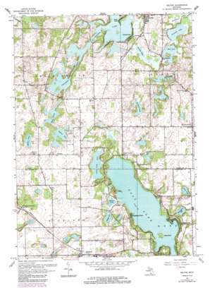
Delton Topo Map Michigan
To zoom in, hover over the map of Delton
USGS Topo Quad 42085d4 - 1:24,000 scale
| Topo Map Name: | Delton |
| USGS Topo Quad ID: | 42085d4 |
| Print Size: | ca. 21 1/4" wide x 27" high |
| Southeast Coordinates: | 42.375° N latitude / 85.375° W longitude |
| Map Center Coordinates: | 42.4375° N latitude / 85.4375° W longitude |
| U.S. State: | MI |
| Filename: | o42085d4.jpg |
| Download Map JPG Image: | Delton topo map 1:24,000 scale |
| Map Type: | Topographic |
| Topo Series: | 7.5´ |
| Map Scale: | 1:24,000 |
| Source of Map Images: | United States Geological Survey (USGS) |
| Alternate Map Versions: |
Delton MI 1947, updated 1955 Download PDF Buy paper map Delton MI 1961, updated 1962 Download PDF Buy paper map Delton MI 1961, updated 1973 Download PDF Buy paper map Delton MI 1961, updated 1985 Download PDF Buy paper map Delton MI 2011 Download PDF Buy paper map Delton MI 2014 Download PDF Buy paper map Delton MI 2016 Download PDF Buy paper map |
1:24,000 Topo Quads surrounding Delton
> Back to 42085a1 at 1:100,000 scale
> Back to 42084a1 at 1:250,000 scale
> Back to U.S. Topo Maps home
Delton topo map: Gazetteer
Delton: Airports
Charles Airport elevation 292m 958′Delton: Lakes
Bullhead Lake elevation 281m 921′Crooked Lake elevation 284m 931′
Dake Lake elevation 281m 921′
Duck Lake elevation 273m 895′
Glasby Lake elevation 282m 925′
Grassy Lake elevation 270m 885′
Gull Lake elevation 268m 879′
Indian Lake elevation 278m 912′
Little Long Lake elevation 271m 889′
Miller Lake elevation 268m 879′
Miller Lake elevation 276m 905′
Mud Lake elevation 282m 925′
Pleasant Lake elevation 282m 925′
West Gilkey Lake elevation 278m 912′
Wintergreen Lake elevation 272m 892′
Delton: Parks
Community Library Historical Marker elevation 283m 928′First Presbyterian Church Historical Marker elevation 283m 928′
Island Park elevation 269m 882′
Thomas' Mills Historical Marker elevation 268m 879′
W K Kellogg House Historical Marker elevation 279m 915′
Delton: Populated Places
Cressey elevation 287m 941′Delton elevation 288m 944′
Hickory Corners elevation 293m 961′
Highland Park elevation 274m 898′
Midland Park elevation 272m 892′
Richland elevation 283m 928′
Richland Junction elevation 281m 921′
South Gull Lake elevation 268m 879′
Stoney Point Trailer Park elevation 284m 931′
Stony Point elevation 282m 925′
Turners Corner elevation 276m 905′
Woodlawn Beach elevation 271m 889′
Yorkville elevation 277m 908′
Delton: Post Offices
Cressey Post Office (historical) elevation 287m 941′Delton Post Office elevation 288m 944′
Gull Lake Post Office (historical) elevation 274m 898′
Hickory Corners Post Office elevation 293m 961′
Milo Post Office (historical) elevation 293m 961′
Richland Post Office elevation 283m 928′
Springbrook Post Office (historical) elevation 279m 915′
Yorkville Post Office (historical) elevation 276m 905′
Delton: Summits
The Hogback elevation 287m 941′Delton: Swamps
Blachman Swamp elevation 285m 935′Delton digital topo map on disk
Buy this Delton topo map showing relief, roads, GPS coordinates and other geographical features, as a high-resolution digital map file on DVD:
Northern Illinois, Northern Indiana & Southwestern Michigan
Buy digital topo maps: Northern Illinois, Northern Indiana & Southwestern Michigan


