Nashville Topo Map Michigan
To zoom in, hover over the map of Nashville
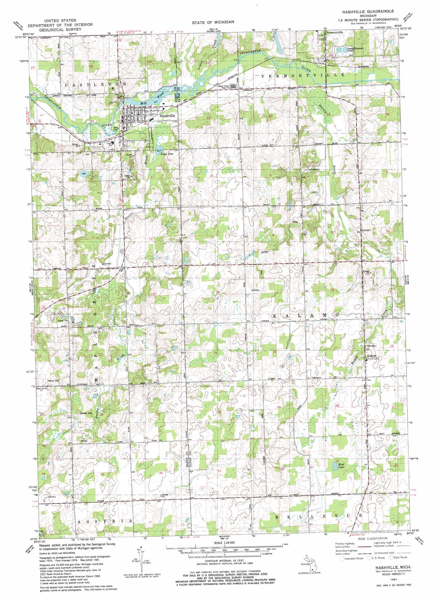
USGS Topo Quad 42085e1 - 1:24,000 scale
| Topo Map Name: | Nashville |
| USGS Topo Quad ID: | 42085e1 |
| Print Size: | ca. 21 1/4" wide x 27" high |
| Southeast Coordinates: | 42.5° N latitude / 85° W longitude |
| Map Center Coordinates: | 42.5625° N latitude / 85.0625° W longitude |
| U.S. State: | MI |
| Filename: | o42085e1.jpg |
| Download Map JPG Image: | Nashville topo map 1:24,000 scale |
| Map Type: | Topographic |
| Topo Series: | 7.5´ |
| Map Scale: | 1:24,000 |
| Source of Map Images: | United States Geological Survey (USGS) |
| Alternate Map Versions: |
Nashville MI 1981, updated 1981 Download PDF Buy paper map Nashville MI 2011 Download PDF Buy paper map Nashville MI 2014 Download PDF Buy paper map Nashville MI 2016 Download PDF Buy paper map |
1:24,000 Topo Quads surrounding Nashville
Freeport |
Lake Odessa |
Woodbury |
Portland South |
Eagle |
Hastings |
Woodland |
Saubee Lake |
Hoytville |
Needmore |
Dowling |
Maple Grove |
Nashville |
Chester |
Charlotte |
Banfield |
Bedford |
Bellevue |
Olivet |
Duck Lake |
Augusta |
Battle Creek |
Ceresco |
Marshall |
Northwest Albion |
> Back to 42085e1 at 1:100,000 scale
> Back to 42084a1 at 1:250,000 scale
> Back to U.S. Topo Maps home
Nashville topo map: Gazetteer
Nashville: Lakes
Lake One elevation 248m 813′Mill Pond elevation 248m 813′
Mud Lake elevation 281m 921′
Nashville: Parks
First Congregational Church Historical Marker elevation 286m 938′Putnam Public Library Historical Marker elevation 251m 823′
Nashville: Populated Places
Kalamo elevation 288m 944′Nashville elevation 250m 820′
Nashville: Post Offices
Kalamo Post Office (historical) elevation 288m 944′Nashville Post Office elevation 251m 823′
Nashville: Streams
Hayon Creek elevation 252m 826′Quaker Brook elevation 246m 807′
Scipio Creek elevation 248m 813′
Shanty Brook elevation 249m 816′
Nashville digital topo map on disk
Buy this Nashville topo map showing relief, roads, GPS coordinates and other geographical features, as a high-resolution digital map file on DVD:
Northern Illinois, Northern Indiana & Southwestern Michigan
Buy digital topo maps: Northern Illinois, Northern Indiana & Southwestern Michigan