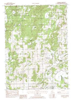
Cloverdale Topo Map Michigan
To zoom in, hover over the map of Cloverdale
USGS Topo Quad 42085e4 - 1:24,000 scale
| Topo Map Name: | Cloverdale |
| USGS Topo Quad ID: | 42085e4 |
| Print Size: | ca. 21 1/4" wide x 27" high |
| Southeast Coordinates: | 42.5° N latitude / 85.375° W longitude |
| Map Center Coordinates: | 42.5625° N latitude / 85.4375° W longitude |
| U.S. State: | MI |
| Filename: | o42085e4.jpg |
| Download Map JPG Image: | Cloverdale topo map 1:24,000 scale |
| Map Type: | Topographic |
| Topo Series: | 7.5´ |
| Map Scale: | 1:24,000 |
| Source of Map Images: | United States Geological Survey (USGS) |
| Alternate Map Versions: |
Cloverdale MI 1982, updated 1982 Download PDF Buy paper map Cloverdale MI 1982, updated 1982 Download PDF Buy paper map Cloverdale MI 2011 Download PDF Buy paper map Cloverdale MI 2014 Download PDF Buy paper map Cloverdale MI 2016 Download PDF Buy paper map |
1:24,000 Topo Quads surrounding Cloverdale
> Back to 42085e1 at 1:100,000 scale
> Back to 42084a1 at 1:250,000 scale
> Back to U.S. Topo Maps home
Cloverdale topo map: Gazetteer
Cloverdale: Lakes
Adams Lake elevation 271m 889′Blue Lake elevation 277m 908′
Bullhead Lake elevation 246m 807′
Cloverdale Lake elevation 281m 921′
Crystal Lake elevation 252m 826′
Dagget Lake elevation 285m 935′
Deep Lake elevation 246m 807′
Fawn Lake elevation 232m 761′
Fish Lake elevation 238m 780′
Guernsey Lake elevation 277m 908′
Hall Lake elevation 236m 774′
Head Lake elevation 275m 902′
Holcomb Lake elevation 281m 921′
Horseshoe Lake elevation 239m 784′
Lime Lake elevation 238m 780′
Loomis Lake elevation 279m 915′
Mud Lake elevation 282m 925′
Number Twenty-one Lake elevation 280m 918′
Orr Lake elevation 277m 908′
Otis Lake elevation 261m 856′
Pine Lake elevation 272m 892′
Snow Lake elevation 255m 836′
Stewart Lake elevation 261m 856′
Tamarack Lake elevation 241m 790′
Wall Lake elevation 282m 925′
Wiley Lake elevation 280m 918′
Wilkinson Lake elevation 281m 921′
Cloverdale: Parks
Barry State Game Area elevation 285m 935′Otis Sanctuary elevation 282m 925′
Yankee Springs Inn Historical Marker elevation 262m 859′
Yankee Springs Recreation Area elevation 242m 793′
Cloverdale: Populated Places
Circle Pine Center elevation 298m 977′Cloverdale elevation 281m 921′
Guernsey Lake Mobile Home Court elevation 279m 915′
Prairieville elevation 299m 980′
Cloverdale: Post Offices
Cloverdale Post Office elevation 277m 908′Prairieville Post Office (historical) elevation 299m 980′
Yankee Spring Post Office (historical) elevation 265m 869′
Cloverdale digital topo map on disk
Buy this Cloverdale topo map showing relief, roads, GPS coordinates and other geographical features, as a high-resolution digital map file on DVD:
Northern Illinois, Northern Indiana & Southwestern Michigan
Buy digital topo maps: Northern Illinois, Northern Indiana & Southwestern Michigan


