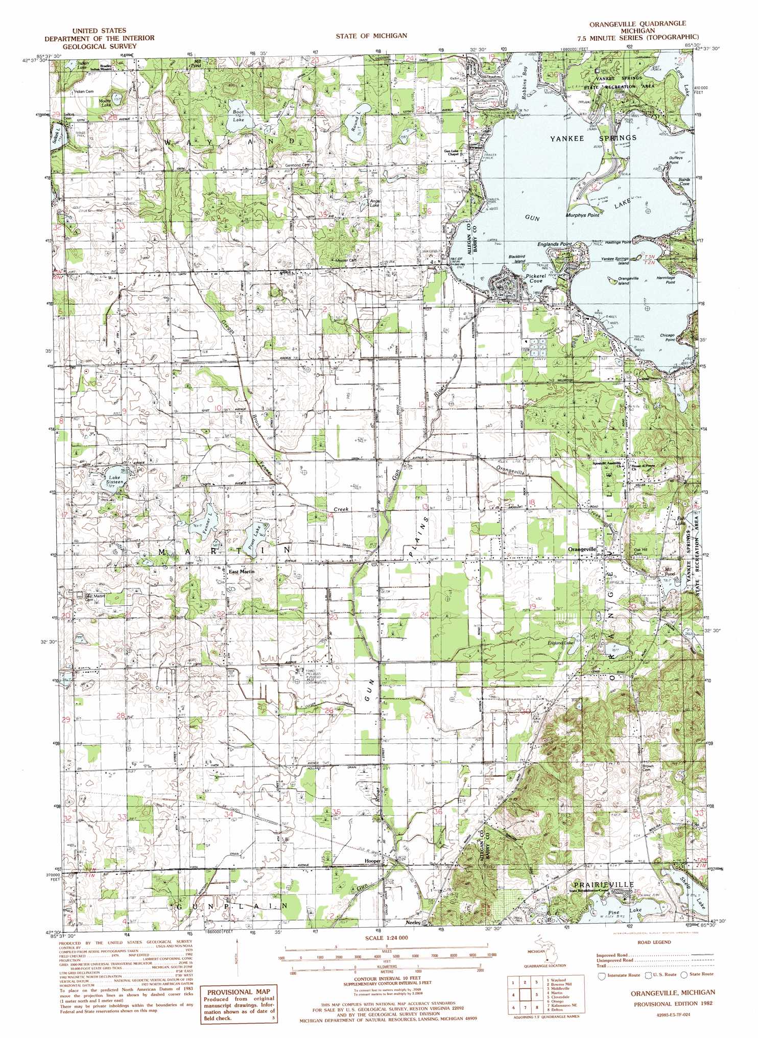
Orangeville Topo Map Michigan
To zoom in, hover over the map of Orangeville
USGS Topo Quad 42085e5 - 1:24,000 scale
| Topo Map Name: | Orangeville |
| USGS Topo Quad ID: | 42085e5 |
| Print Size: | ca. 21 1/4" wide x 27" high |
| Southeast Coordinates: | 42.5° N latitude / 85.5° W longitude |
| Map Center Coordinates: | 42.5625° N latitude / 85.5625° W longitude |
| U.S. State: | MI |
| Filename: | o42085e5.jpg |
| Download Map JPG Image: | Orangeville topo map 1:24,000 scale |
| Map Type: | Topographic |
| Topo Series: | 7.5´ |
| Map Scale: | 1:24,000 |
| Source of Map Images: | United States Geological Survey (USGS) |
| Alternate Map Versions: |
Orangeville MI 1982, updated 1982 Download PDF Buy paper map Orangeville MI 2011 Download PDF Buy paper map Orangeville MI 2014 Download PDF Buy paper map Orangeville MI 2016 Download PDF Buy paper map |
1:24,000 Topo Quads surrounding Orangeville
Hudsonville East |
Cutlerville |
Caledonia |
Alto |
Freeport |
Burnips |
Wayland |
Bowens Mill |
Middleville |
Hastings |
Allegan |
Martin |
Orangeville |
Cloverdale |
Dowling |
Merson |
Otsego |
Kalamazoo Ne |
Delton |
Banfield |
Gobles East |
Kalamazoo Sw |
Kalamazoo |
Galesburg |
Augusta |
> Back to 42085e1 at 1:100,000 scale
> Back to 42084a1 at 1:250,000 scale
> Back to U.S. Topo Maps home
Orangeville topo map: Gazetteer
Orangeville: Bays
Bairds Cove elevation 227m 744′Pickerel Cove elevation 227m 744′
Orangeville: Capes
Chicago Point elevation 235m 770′Duffeys Point elevation 227m 744′
Englands Point elevation 231m 757′
Hastings Point elevation 232m 761′
Hermitage Point elevation 229m 751′
Murphys Point elevation 228m 748′
Orangeville: Flats
Gun Plains elevation 226m 741′Orangeville: Islands
Blackbird Island elevation 227m 744′Orangeville Island elevation 227m 744′
Yankee Springs Island elevation 227m 744′
Orangeville: Lakes
Angel Lake elevation 237m 777′Angel Lake elevation 237m 777′
Boot Lake elevation 235m 770′
England Lake elevation 231m 757′
Fenner Lake elevation 233m 764′
Gun Lake elevation 227m 744′
Indian Lake elevation 232m 761′
Lake Sixteen elevation 237m 777′
Long Lake elevation 226m 741′
Mill Pond elevation 238m 780′
Moore Lake elevation 237m 777′
Pratt Lake elevation 232m 761′
Round Lake elevation 232m 761′
Shelp Lake elevation 273m 895′
Orangeville: Populated Places
East Martin elevation 242m 793′Hooper elevation 224m 734′
Neeley elevation 242m 793′
Orangeville elevation 235m 770′
Orangeville: Post Offices
Gunlake Post Office (historical) elevation 231m 757′Hooper Post Office (historical) elevation 224m 734′
Orangeville Post Office (historical) elevation 235m 770′
Orangeville: Streams
Fenner Creek elevation 225m 738′Greggs Brook elevation 225m 738′
Orangeville Creek elevation 225m 738′
Orangeville digital topo map on disk
Buy this Orangeville topo map showing relief, roads, GPS coordinates and other geographical features, as a high-resolution digital map file on DVD:
Northern Illinois, Northern Indiana & Southwestern Michigan
Buy digital topo maps: Northern Illinois, Northern Indiana & Southwestern Michigan