Millgrove Topo Map Michigan
To zoom in, hover over the map of Millgrove
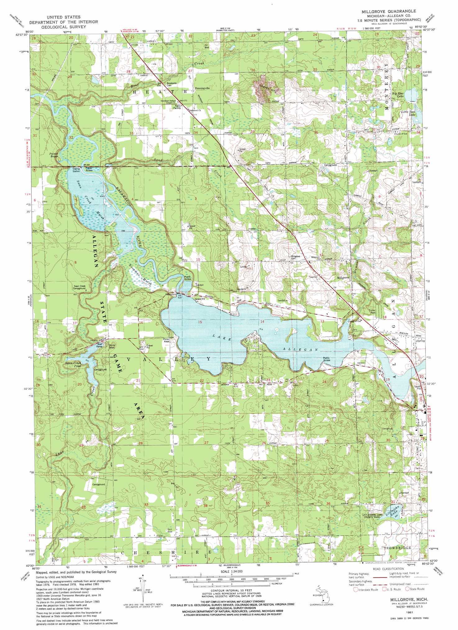
USGS Topo Quad 42085e8 - 1:24,000 scale
| Topo Map Name: | Millgrove |
| USGS Topo Quad ID: | 42085e8 |
| Print Size: | ca. 21 1/4" wide x 27" high |
| Southeast Coordinates: | 42.5° N latitude / 85.875° W longitude |
| Map Center Coordinates: | 42.5625° N latitude / 85.9375° W longitude |
| U.S. State: | MI |
| Filename: | o42085e8.jpg |
| Download Map JPG Image: | Millgrove topo map 1:24,000 scale |
| Map Type: | Topographic |
| Topo Series: | 7.5´ |
| Map Scale: | 1:24,000 |
| Source of Map Images: | United States Geological Survey (USGS) |
| Alternate Map Versions: |
Millgrove MI 1981, updated 1981 Download PDF Buy paper map Millgrove MI 2011 Download PDF Buy paper map Millgrove MI 2014 Download PDF Buy paper map Millgrove MI 2016 Download PDF Buy paper map |
1:24,000 Topo Quads surrounding Millgrove
Holland West |
Holland East |
Hudsonville West |
Hudsonville East |
Cutlerville |
Saugatuck |
Hamilton West |
Hamilton East |
Burnips |
Wayland |
Glenn |
Fennville |
Millgrove |
Allegan |
Martin |
Lacota |
Pullman |
Bloomingdale |
Merson |
Otsego |
Mcdonald |
Bangor |
Gobles West |
Gobles East |
Kalamazoo Sw |
> Back to 42085e1 at 1:100,000 scale
> Back to 42084a1 at 1:250,000 scale
> Back to U.S. Topo Maps home
Millgrove topo map: Gazetteer
Millgrove: Forests
Allegan State Forest elevation 207m 679′Millgrove: Lakes
Big Spec Lake elevation 223m 731′Little Spec Lake elevation 220m 721′
Littlejohn Lake elevation 211m 692′
Swan Creek Pond elevation 189m 620′
Millgrove: Parks
Littlejohn Lake County Park elevation 215m 705′Millgrove: Populated Places
Dunningville elevation 205m 672′Homecrest Villa Mobile Home Park elevation 214m 702′
Millgrove elevation 212m 695′
Millgrove: Post Offices
Dunningville Post Office (historical) elevation 205m 672′Millgrove Post Office (historical) elevation 212m 695′
Millgrove: Reservoirs
Lake Allegan elevation 183m 600′Millgrove: Streams
Bear Creek elevation 182m 597′Dumont Creek elevation 187m 613′
Palmer Bayou elevation 182m 597′
Sand Creek elevation 182m 597′
Swan Creek elevation 182m 597′
Millgrove: Swamps
Swan Creek Marsh elevation 182m 597′Millgrove digital topo map on disk
Buy this Millgrove topo map showing relief, roads, GPS coordinates and other geographical features, as a high-resolution digital map file on DVD:
Northern Illinois, Northern Indiana & Southwestern Michigan
Buy digital topo maps: Northern Illinois, Northern Indiana & Southwestern Michigan