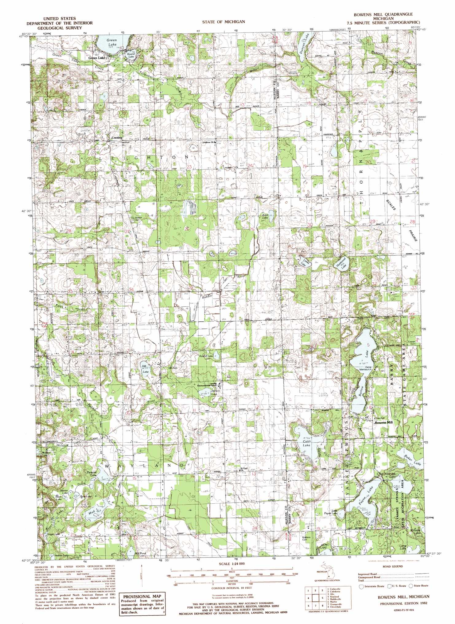
Bowens Mill Topo Map Michigan
To zoom in, hover over the map of Bowens Mill
USGS Topo Quad 42085f5 - 1:24,000 scale
| Topo Map Name: | Bowens Mill |
| USGS Topo Quad ID: | 42085f5 |
| Print Size: | ca. 21 1/4" wide x 27" high |
| Southeast Coordinates: | 42.625° N latitude / 85.5° W longitude |
| Map Center Coordinates: | 42.6875° N latitude / 85.5625° W longitude |
| U.S. State: | MI |
| Filename: | o42085f5.jpg |
| Download Map JPG Image: | Bowens Mill topo map 1:24,000 scale |
| Map Type: | Topographic |
| Topo Series: | 7.5´ |
| Map Scale: | 1:24,000 |
| Source of Map Images: | United States Geological Survey (USGS) |
| Alternate Map Versions: |
Bowens Mill MI 1982, updated 1982 Download PDF Buy paper map Bowens Mill MI 2011 Download PDF Buy paper map Bowens Mill MI 2014 Download PDF Buy paper map Bowens Mill MI 2016 Download PDF Buy paper map |
1:24,000 Topo Quads surrounding Bowens Mill
Grandville |
Grand Rapids West |
Grand Rapids East |
Cascade |
Lowell |
Hudsonville East |
Cutlerville |
Caledonia |
Alto |
Freeport |
Burnips |
Wayland |
Bowens Mill |
Middleville |
Hastings |
Allegan |
Martin |
Orangeville |
Cloverdale |
Dowling |
Merson |
Otsego |
Kalamazoo Ne |
Delton |
Banfield |
> Back to 42085e1 at 1:100,000 scale
> Back to 42084a1 at 1:250,000 scale
> Back to U.S. Topo Maps home
Bowens Mill topo map: Gazetteer
Bowens Mill: Areas
Scales Prairie elevation 254m 833′Bowens Mill: Canals
Cuddy Drain elevation 234m 767′McIntire Lake Drain elevation 233m 764′
Sager Lake Drain elevation 238m 780′
Tollenbar Drain elevation 243m 797′
Wilson Drain elevation 244m 800′
Bowens Mill: Lakes
Aubil Lake elevation 245m 803′Baker Lake elevation 228m 748′
Barlow Lake elevation 234m 767′
Bass Lake elevation 232m 761′
Black Lake elevation 233m 764′
Chief Noonday Lake elevation 228m 748′
Cobb Lake elevation 233m 764′
Hardwood Lake elevation 246m 807′
Hill Lake elevation 237m 777′
Jackson Lake elevation 239m 784′
Leeks Lake elevation 241m 790′
Little Payne Lake elevation 228m 748′
Mill Pond elevation 235m 770′
Mud Lake elevation 233m 764′
Payne Lake elevation 228m 748′
Pickerel Lake elevation 233m 764′
Round Lake elevation 241m 790′
Round Lake elevation 244m 800′
Sager Lake elevation 234m 767′
Squaw Lake elevation 232m 761′
Bowens Mill: Parks
Bowen's Mills Historical Marker elevation 234m 767′Bowens Mill: Populated Places
Bowens Mill elevation 234m 767′Corning elevation 257m 843′
Green Lake elevation 247m 810′
Green Lake elevation 246m 807′
Northbrook Mobile Home Estates elevation 230m 754′
Bowens Mill: Post Offices
Bowens Mills Post Office (historical) elevation 234m 767′Corning Post Office (historical) elevation 256m 839′
Greenlake Post Office (historical) elevation 246m 807′
Bowens Mill digital topo map on disk
Buy this Bowens Mill topo map showing relief, roads, GPS coordinates and other geographical features, as a high-resolution digital map file on DVD:
Northern Illinois, Northern Indiana & Southwestern Michigan
Buy digital topo maps: Northern Illinois, Northern Indiana & Southwestern Michigan