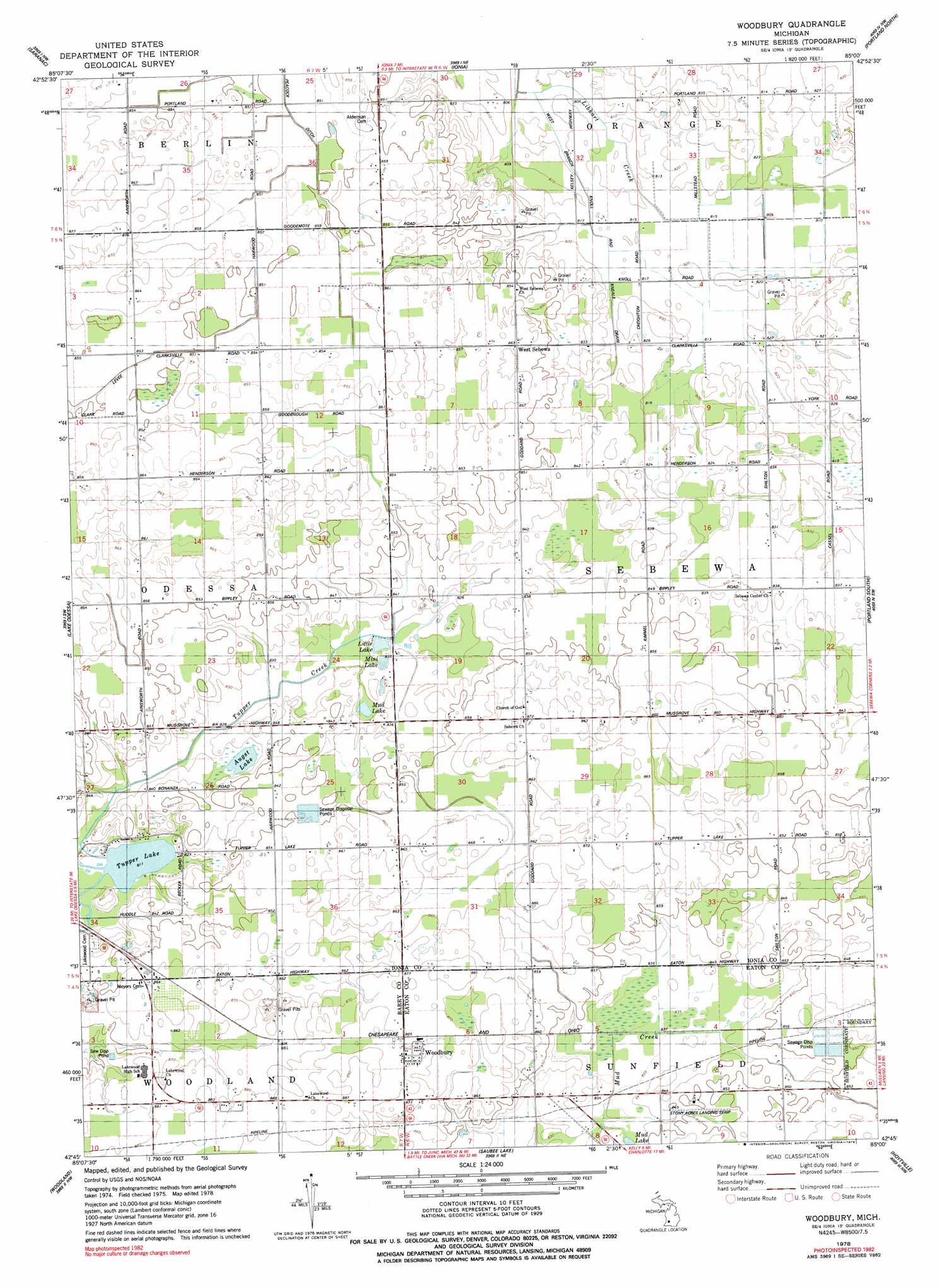
Woodbury Topo Map Michigan
To zoom in, hover over the map of Woodbury
USGS Topo Quad 42085g1 - 1:24,000 scale
| Topo Map Name: | Woodbury |
| USGS Topo Quad ID: | 42085g1 |
| Print Size: | ca. 21 1/4" wide x 27" high |
| Southeast Coordinates: | 42.75° N latitude / 85° W longitude |
| Map Center Coordinates: | 42.8125° N latitude / 85.0625° W longitude |
| U.S. State: | MI |
| Filename: | o42085g1.jpg |
| Download Map JPG Image: | Woodbury topo map 1:24,000 scale |
| Map Type: | Topographic |
| Topo Series: | 7.5´ |
| Map Scale: | 1:24,000 |
| Source of Map Images: | United States Geological Survey (USGS) |
| Alternate Map Versions: |
Woodbury MI 1978, updated 1979 Download PDF Buy paper map Woodbury MI 1978, updated 1979 Download PDF Buy paper map Woodbury MI 2011 Download PDF Buy paper map Woodbury MI 2014 Download PDF Buy paper map Woodbury MI 2016 Download PDF Buy paper map |
1:24,000 Topo Quads surrounding Woodbury
Smyrna |
Belding |
Shiloh |
Palo |
Hubbardston |
Lowell |
Saranac |
Ionia |
Portland North |
Wasphalia |
Freeport |
Lake Odessa |
Woodbury |
Portland South |
Eagle |
Hastings |
Woodland |
Saubee Lake |
Hoytville |
Needmore |
Dowling |
Maple Grove |
Nashville |
Chester |
Charlotte |
> Back to 42085e1 at 1:100,000 scale
> Back to 42084a1 at 1:250,000 scale
> Back to U.S. Topo Maps home
Woodbury topo map: Gazetteer
Woodbury: Airports
Stony Acres Airport elevation 259m 849′Woodbury: Canals
Peacock Ditch elevation 259m 849′West Branch Knoll and Kneale Drain elevation 248m 813′
Woodbury: Lakes
Augst Lake elevation 252m 826′Little Lake elevation 253m 830′
Mini Lake elevation 253m 830′
Mud Lake elevation 255m 836′
Mud Lake elevation 252m 826′
Tupper Lake elevation 248m 813′
Woodbury: Populated Places
West Sebewa elevation 263m 862′Woodbury elevation 269m 882′
Woodbury: Post Offices
Rosina Post Office (historical) elevation 262m 859′West Sebewa Post Office (historical) elevation 263m 862′
Woodbury Post Office (historical) elevation 269m 882′
Woodbury: Streams
Tupper Creek elevation 248m 813′Woodbury digital topo map on disk
Buy this Woodbury topo map showing relief, roads, GPS coordinates and other geographical features, as a high-resolution digital map file on DVD:
Northern Illinois, Northern Indiana & Southwestern Michigan
Buy digital topo maps: Northern Illinois, Northern Indiana & Southwestern Michigan