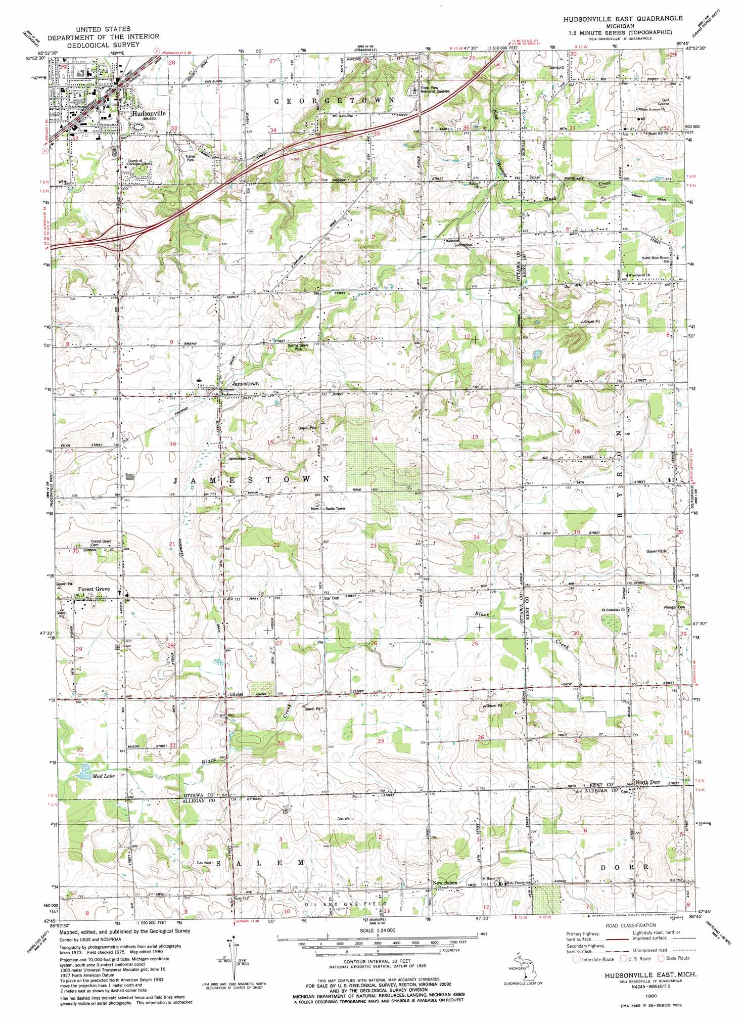
Hudsonville East Topo Map Michigan
To zoom in, hover over the map of Hudsonville East
USGS Topo Quad 42085g7 - 1:24,000 scale
| Topo Map Name: | Hudsonville East |
| USGS Topo Quad ID: | 42085g7 |
| Print Size: | ca. 21 1/4" wide x 27" high |
| Southeast Coordinates: | 42.75° N latitude / 85.75° W longitude |
| Map Center Coordinates: | 42.8125° N latitude / 85.8125° W longitude |
| U.S. State: | MI |
| Filename: | o42085g7.jpg |
| Download Map JPG Image: | Hudsonville East topo map 1:24,000 scale |
| Map Type: | Topographic |
| Topo Series: | 7.5´ |
| Map Scale: | 1:24,000 |
| Source of Map Images: | United States Geological Survey (USGS) |
| Alternate Map Versions: |
Hudsonville East MI 1980, updated 1980 Download PDF Buy paper map Hudsonville East MI 2011 Download PDF Buy paper map Hudsonville East MI 2014 Download PDF Buy paper map Hudsonville East MI 2017 Download PDF Buy paper map |
1:24,000 Topo Quads surrounding Hudsonville East
Nunica |
Coopersville |
Marne |
Cedar Springs Sw |
Rockford |
Borculo |
Allendale |
Grandville |
Grand Rapids West |
Grand Rapids East |
Holland East |
Hudsonville West |
Hudsonville East |
Cutlerville |
Caledonia |
Hamilton West |
Hamilton East |
Burnips |
Wayland |
Bowens Mill |
Fennville |
Millgrove |
Allegan |
Martin |
Orangeville |
> Back to 42085e1 at 1:100,000 scale
> Back to 42084a1 at 1:250,000 scale
> Back to U.S. Topo Maps home
Hudsonville East topo map: Gazetteer
Hudsonville East: Crossings
Interchange 3 elevation 210m 688′Interchange 62 elevation 209m 685′
Hudsonville East: Lakes
Mud Lake elevation 200m 656′Hudsonville East: Parks
Hudsonville Nature Center elevation 207m 679′Jamestown Reformed Church Historical Marker elevation 217m 711′
Spring Grove Park elevation 214m 702′
Veterans Park elevation 194m 636′
Hudsonville East: Populated Places
Country Hills Village Mobile Home Park elevation 214m 702′Forest Grove elevation 239m 784′
Gitchel elevation 213m 698′
Hudsonville elevation 193m 633′
Jamestown elevation 217m 711′
New Salem elevation 209m 685′
North Dorr elevation 229m 751′
Presidential Estates Mobile Home Park elevation 199m 652′
Hudsonville East: Post Offices
Debri Post Office (historical) elevation 230m 754′Forestgrove Post Office (historical) elevation 239m 784′
Gitchel Post Office (historical) elevation 213m 698′
Hanley Post Office (historical) elevation 205m 672′
Hudsonville Post Office elevation 195m 639′
New Salem Post Office (historical) elevation 209m 685′
North Dorr Post Office (historical) elevation 233m 764′
Hudsonville East digital topo map on disk
Buy this Hudsonville East topo map showing relief, roads, GPS coordinates and other geographical features, as a high-resolution digital map file on DVD:
Northern Illinois, Northern Indiana & Southwestern Michigan
Buy digital topo maps: Northern Illinois, Northern Indiana & Southwestern Michigan