Ionia Topo Map Michigan
To zoom in, hover over the map of Ionia
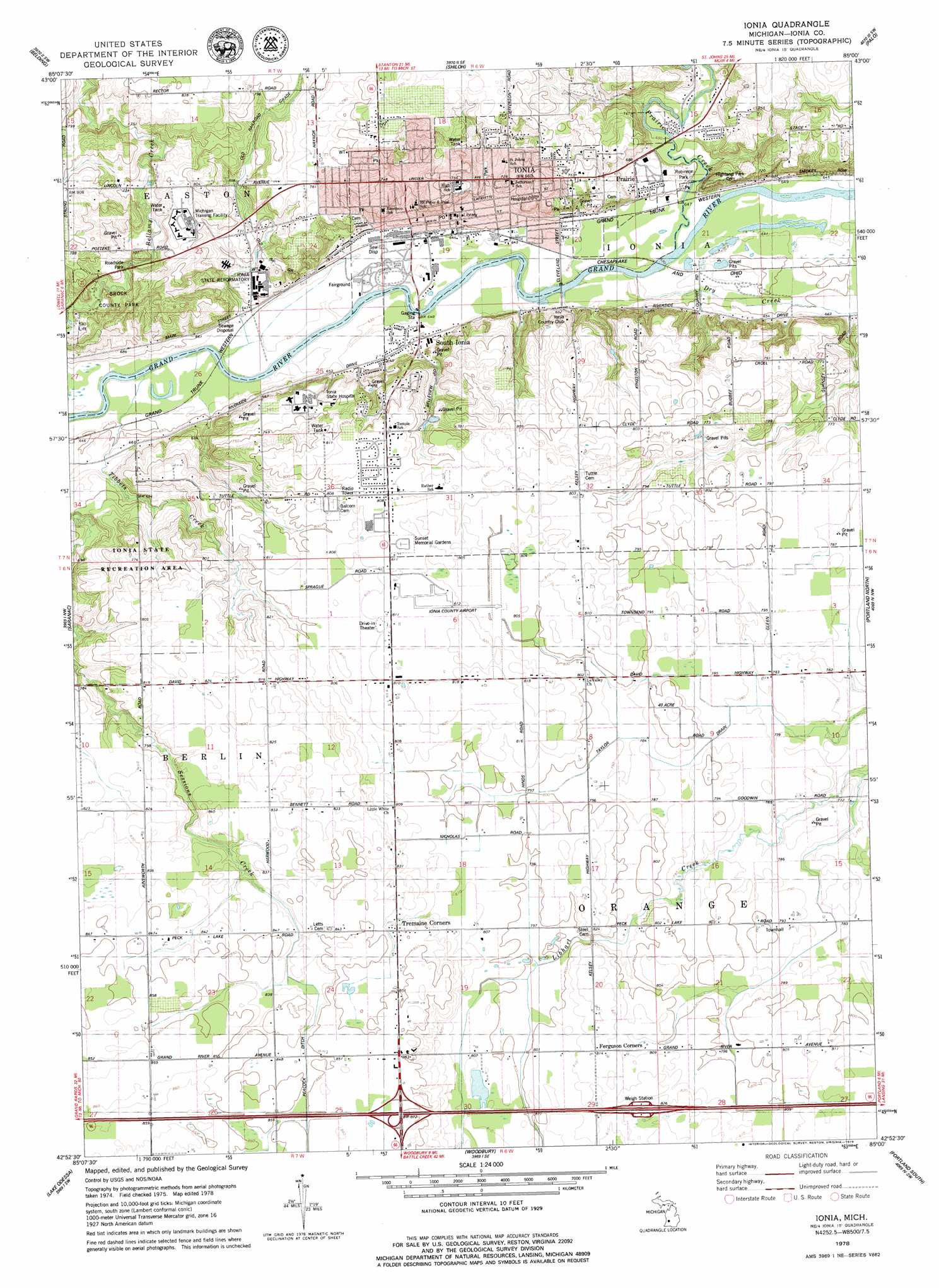
USGS Topo Quad 42085h1 - 1:24,000 scale
| Topo Map Name: | Ionia |
| USGS Topo Quad ID: | 42085h1 |
| Print Size: | ca. 21 1/4" wide x 27" high |
| Southeast Coordinates: | 42.875° N latitude / 85° W longitude |
| Map Center Coordinates: | 42.9375° N latitude / 85.0625° W longitude |
| U.S. State: | MI |
| Filename: | o42085h1.jpg |
| Download Map JPG Image: | Ionia topo map 1:24,000 scale |
| Map Type: | Topographic |
| Topo Series: | 7.5´ |
| Map Scale: | 1:24,000 |
| Source of Map Images: | United States Geological Survey (USGS) |
| Alternate Map Versions: |
Ionia MI 1978, updated 1979 Download PDF Buy paper map Ionia MI 2011 Download PDF Buy paper map Ionia MI 2014 Download PDF Buy paper map Ionia MI 2016 Download PDF Buy paper map |
1:24,000 Topo Quads surrounding Ionia
Greenville West |
Greenville East |
Sheridan |
Butternut |
Carson City |
Smyrna |
Belding |
Shiloh |
Palo |
Hubbardston |
Lowell |
Saranac |
Ionia |
Portland North |
Wasphalia |
Freeport |
Lake Odessa |
Woodbury |
Portland South |
Eagle |
Hastings |
Woodland |
Saubee Lake |
Hoytville |
Needmore |
> Back to 42085e1 at 1:100,000 scale
> Back to 42084a1 at 1:250,000 scale
> Back to U.S. Topo Maps home
Ionia topo map: Gazetteer
Ionia: Airports
Ionia County Airport elevation 245m 803′Ionia: Canals
Taylor Drain elevation 239m 784′Ionia: Crossings
Interchange 67 elevation 261m 856′Ionia: Parks
Balice Park elevation 199m 652′Brock County Park elevation 201m 659′
Fred W Green Historical Marker elevation 221m 725′
Frederick Hall House Historical Marker elevation 200m 656′
Hale Park elevation 216m 708′
Harper Park elevation 226m 741′
Ionia Church of Christ Historical Marker elevation 203m 666′
Ionia County Courthouse Historical Marker elevation 201m 659′
Jackson Street Tennis Courts elevation 213m 698′
John and Harriet Blanchard House Historical Marker elevation 201m 659′
John C Blanchard Historical Marker elevation 201m 659′
McCann Park elevation 214m 702′
Robinson Park elevation 201m 659′
Saint John's Episcopal Church and Parish House Historical Marker elevation 201m 659′
Shattuck Park elevation 196m 643′
Skate Park elevation -1m -4′
Ionia: Populated Places
Canterbury Estates Mobile Home Park elevation 247m 810′Ionia elevation 219m 718′
Prairie elevation 200m 656′
Sherwood Forest Mobile Home Park elevation 230m 754′
South Ionia elevation 198m 649′
Tremaine Corners elevation 256m 839′
Ionia: Post Offices
Ionia Post Office elevation 201m 659′Orange Post Office (historical) elevation 250m 820′
Ionia: Streams
Dry Creek elevation 200m 656′Prairie Creek elevation 192m 629′
Tibbetts Creek elevation 192m 629′
Ionia digital topo map on disk
Buy this Ionia topo map showing relief, roads, GPS coordinates and other geographical features, as a high-resolution digital map file on DVD:
Northern Illinois, Northern Indiana & Southwestern Michigan
Buy digital topo maps: Northern Illinois, Northern Indiana & Southwestern Michigan