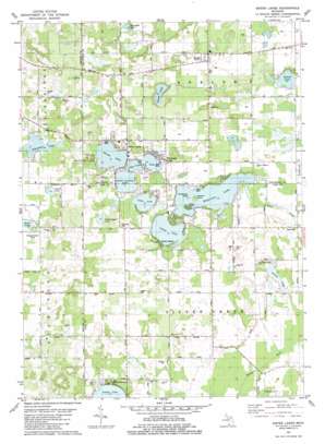
Sister Lakes Topo Map Michigan
To zoom in, hover over the map of Sister Lakes
USGS Topo Quad 42086a2 - 1:24,000 scale
| Topo Map Name: | Sister Lakes |
| USGS Topo Quad ID: | 42086a2 |
| Print Size: | ca. 21 1/4" wide x 27" high |
| Southeast Coordinates: | 42° N latitude / 86.125° W longitude |
| Map Center Coordinates: | 42.0625° N latitude / 86.1875° W longitude |
| U.S. State: | MI |
| Filename: | o42086a2.jpg |
| Download Map JPG Image: | Sister Lakes topo map 1:24,000 scale |
| Map Type: | Topographic |
| Topo Series: | 7.5´ |
| Map Scale: | 1:24,000 |
| Source of Map Images: | United States Geological Survey (USGS) |
| Alternate Map Versions: |
Sister Lakes MI 1981, updated 1982 Download PDF Buy paper map Sister Lakes MI 2011 Download PDF Buy paper map Sister Lakes MI 2014 Download PDF Buy paper map Sister Lakes MI 2017 Download PDF Buy paper map |
1:24,000 Topo Quads surrounding Sister Lakes
> Back to 42086a1 at 1:100,000 scale
> Back to 42086a1 at 1:250,000 scale
> Back to U.S. Topo Maps home
Sister Lakes topo map: Gazetteer
Sister Lakes: Islands
Hemlock Island elevation 234m 767′Rattlesnake Island elevation 233m 764′
Sister Lakes: Lakes
Brown Lake elevation 234m 767′Cable Lake elevation 233m 764′
Crooked Lake elevation 232m 761′
Danneffel Lake elevation 218m 715′
Dewey Lake elevation 233m 764′
Grabemeyer Lake elevation 232m 761′
Jarvis Lake elevation 215m 705′
Keeler Lake elevation 238m 780′
Magician Lake elevation 232m 761′
Pipestone Lake elevation 215m 705′
Priest Lake elevation 223m 731′
Round Lake elevation 232m 761′
Rowe Lake elevation 214m 702′
Sister Lakes: Parks
First Methodist Episcopal Church Historical Marker elevation 246m 807′Sacred Heart of Mary Catholic Church Historical Marker elevation 239m 784′
Sister Lakes: Populated Places
Beechwood elevation 232m 761′Indian Lake elevation 232m 761′
Keeler elevation 245m 803′
Maple Island elevation 234m 767′
Sandy Beach elevation 242m 793′
Sister Lakes elevation 234m 767′
White Pines Mobile Home Park elevation 244m 800′
Woodland Beach elevation 247m 810′
Sister Lakes: Post Offices
Keeler Post Office (historical) elevation 245m 803′Pleasant Valley Post Office (historical) elevation 236m 774′
Sister Lakes Post Office (historical) elevation 234m 767′
Sister Lakes: Streams
Silver Creek elevation 221m 725′Sister Lakes: Swamps
Dowagiac Swamp elevation 222m 728′Sister Lakes digital topo map on disk
Buy this Sister Lakes topo map showing relief, roads, GPS coordinates and other geographical features, as a high-resolution digital map file on DVD:
Northern Illinois, Northern Indiana & Southwestern Michigan
Buy digital topo maps: Northern Illinois, Northern Indiana & Southwestern Michigan


