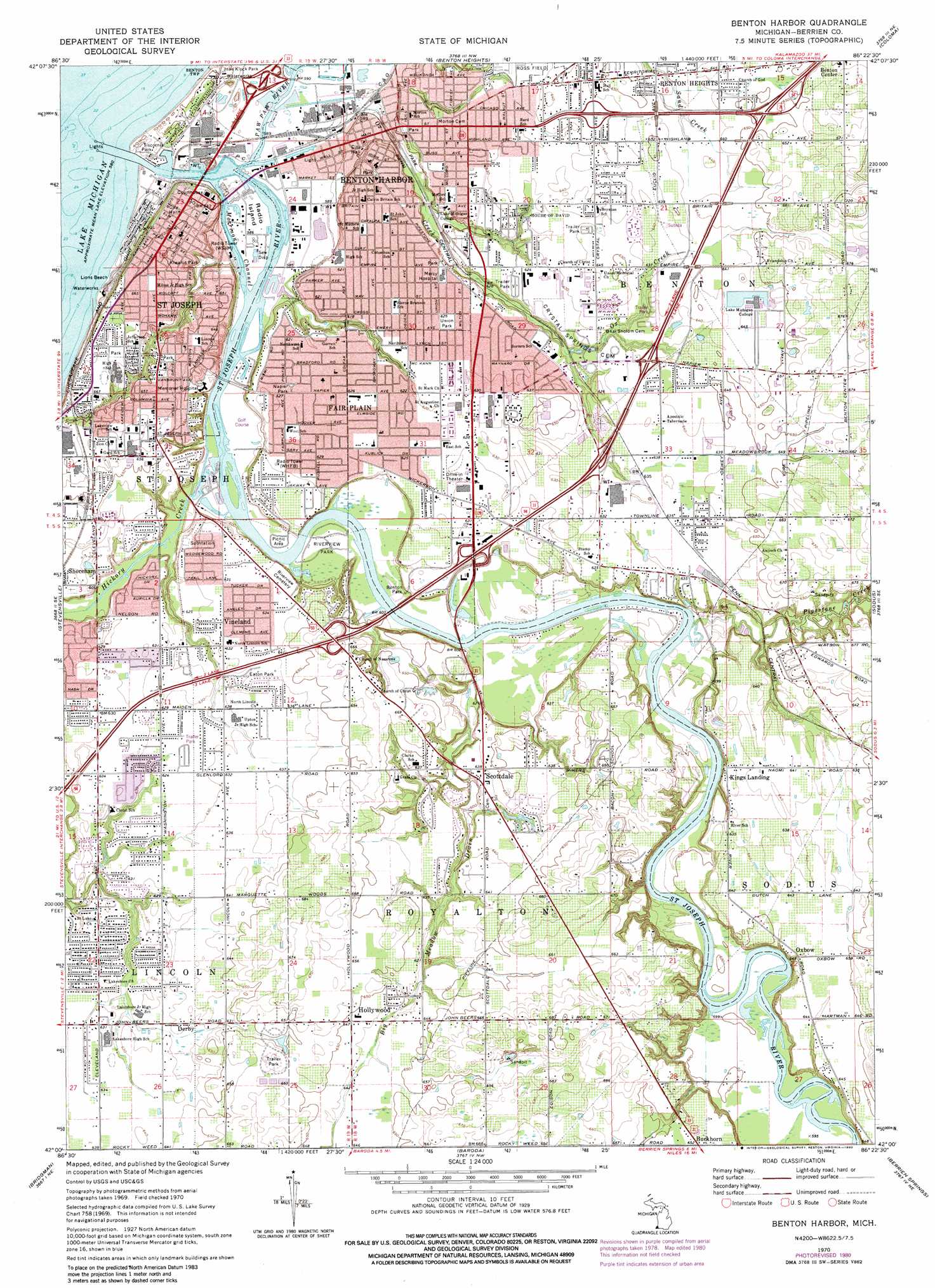
Benton Harbor Topo Map Michigan
To zoom in, hover over the map of Benton Harbor
USGS Topo Quad 42086a4 - 1:24,000 scale
| Topo Map Name: | Benton Harbor |
| USGS Topo Quad ID: | 42086a4 |
| Print Size: | ca. 21 1/4" wide x 27" high |
| Southeast Coordinates: | 42° N latitude / 86.375° W longitude |
| Map Center Coordinates: | 42.0625° N latitude / 86.4375° W longitude |
| U.S. State: | MI |
| Filename: | o42086a4.jpg |
| Download Map JPG Image: | Benton Harbor topo map 1:24,000 scale |
| Map Type: | Topographic |
| Topo Series: | 7.5´ |
| Map Scale: | 1:24,000 |
| Source of Map Images: | United States Geological Survey (USGS) |
| Alternate Map Versions: |
Benton Harbor MI 1970, updated 1973 Download PDF Buy paper map Benton Harbor MI 1970, updated 1980 Download PDF Buy paper map Benton Harbor MI 2011 Download PDF Buy paper map Benton Harbor MI 2014 Download PDF Buy paper map Benton Harbor MI 2017 Download PDF Buy paper map |
1:24,000 Topo Quads surrounding Benton Harbor
Covert |
Mcdonald |
|||
Benton Heights |
Coloma |
Hartford |
||
Stevensville |
Benton Harbor |
Sodus |
Sister Lakes |
|
Bridgman |
Baroda |
Berrien Springs |
Sumnerville |
|
New Buffalo East |
Three Oaks |
Galien |
Niles West |
Niles East |
> Back to 42086a1 at 1:100,000 scale
> Back to 42086a1 at 1:250,000 scale
> Back to U.S. Topo Maps home
Benton Harbor topo map: Gazetteer
Benton Harbor: Beaches
Lions Beach elevation 180m 590′Benton Harbor: Canals
Big Meadow Drain elevation 191m 626′Benton Harbor: Channels
Morrison Channel elevation 177m 580′Benton Harbor: Crossings
Interchange 27 elevation 210m 688′Interchange 28 elevation 193m 633′
Interchange 29 elevation 196m 643′
Interchange 30 elevation 195m 639′
Interchange 33 elevation 199m 652′
Benton Harbor: Islands
Marina Island elevation 179m 587′Benton Harbor: Parks
Benton Park elevation 189m 620′Bicentennial Park elevation 201m 659′
Botham Park elevation 203m 666′
Broadway Park elevation 192m 629′
Burnett's Post Historical Marker elevation 199m 652′
Carronde Park elevation 182m 597′
Cass Park elevation 184m 603′
Dickenson Park elevation 204m 669′
Eaton Park elevation 201m 659′
Fort Miami Historical Marker elevation 185m 606′
Hull Park elevation 177m 580′
Kiwanis Park elevation 179m 587′
Maiden Lane Community Park elevation 200m 656′
Milton Park elevation 204m 669′
Napier Park elevation 192m 629′
Old Saint Joseph Neighborhood Historical Marker elevation 206m 675′
Pipestone Park elevation 190m 623′
Point Park elevation 205m 672′
Riverside Park elevation 183m 600′
Riverview Park elevation 183m 600′
Riverview Park elevation 177m 580′
Saint Joseph City Park elevation 181m 593′
Seitz Park elevation 190m 623′
Silver Beach County Park elevation 178m 583′
The Fruit Belt Historical Marker elevation 196m 643′
The Hogue House Historical Marker elevation 206m 675′
The Morton House Historical Marker elevation 186m 610′
Tiscornia Park elevation 180m 590′
Union Park elevation 192m 629′
Whittlesey Park elevation 194m 636′
Benton Harbor: Populated Places
Benton Center elevation 197m 646′Benton Harbor elevation 181m 593′
Buckhorn elevation 198m 649′
Crystal Mobile Home Park elevation 196m 643′
Derby elevation 192m 629′
Fair Plain elevation 192m 629′
Glen-Aire Mobile Home Park elevation 196m 643′
Hollywood elevation 196m 643′
Kings Landing elevation 198m 649′
Meadow Streams Estate Mobile Home Park elevation 187m 613′
Orchard View Estates elevation 190m 623′
Oxbow elevation 195m 639′
Ravines Mobile Home Park elevation 192m 629′
Saint Joseph elevation 193m 633′
Scottdale elevation 199m 652′
Shady Acres Mobile Home Village elevation 187m 613′
Spring Lake Mobile Home Park elevation 201m 659′
Vineland elevation 203m 666′
Benton Harbor: Post Offices
Benton Harbor Post Office elevation 179m 587′Carl Post Office (historical) elevation 200m 656′
Derby Post Office (historical) elevation 192m 629′
Hollywood Post Office (historical) elevation 196m 643′
Royalton Post Office (historical) elevation 200m 656′
Saint Joseph Post Office elevation 193m 633′
Stevensville Post Office elevation 189m 620′
Vineland Post Office (historical) elevation 203m 666′
Benton Harbor: Streams
Hickory Creek elevation 177m 580′Ox Creek elevation 177m 580′
Paw Paw River elevation 177m 580′
Pipestone Creek elevation 182m 597′
Saint Joseph River elevation 177m 580′
Benton Harbor digital topo map on disk
Buy this Benton Harbor topo map showing relief, roads, GPS coordinates and other geographical features, as a high-resolution digital map file on DVD:
Northern Illinois, Northern Indiana & Southwestern Michigan
Buy digital topo maps: Northern Illinois, Northern Indiana & Southwestern Michigan